Download
1 / 10
100 likes | 124 Views
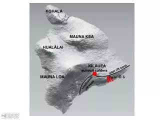
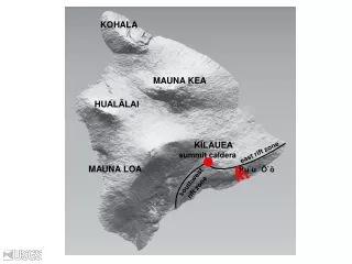
Discover the diverse landscape of Kilauea volcano with information on its various zones, volcanic features like calderas and rift zones, and summit activities. Learn about the lava fountains, flow fields, and ground movements monitored by GPS.

E N D
KOHALA MAUNA KEA HUALĀLAI KĪLAUEA east rift zone summit caldera MAUNA LOA Pu`u `Ō`ō southwest rift zone
summit Pu‘u ‘Ō‘ō Map by J. Johnson 2000, from http://hvo.wr.usgs.gov/kilauea/Kilauea_map.html
June 1983–June 1986: • Pu‘u ‘Ō‘ō dominant vent • Episodic lava fountains (44 total) • Maximum height = ~470 m (~1540 ft) Empire State Building September 1984
Tube-fed flow field and ocean entries summit Pu‘u ‘Ō‘ō December 1987
Image from: USGS Hawaiian Volcano Observatory (http://hvo.wr.usgs.gov/kilauea/update/deformation.html) Modified from https://vepp.wr.usgs.gov/vepp/techniques/gps/
Summit Pu‘u ‘Ō‘ō Ground Tilt
Summit Pu‘u ‘Ō‘ō Ground Movement (Using GPS)