Download
1 / 18
180 likes | 364 Views
A Coastal Observing and Forecasting System for the Baltic Sea. Lennart Funkquist Swedish Meteorological and Hydrological Institute. Workshop on The status of European Coastal Observing and Fprecasting Systems, Majorca, October 2007. Swedish Coastal Waters some areal facts.

E N D
A Coastal Observing and Forecasting System for the Baltic Sea Lennart FunkquistSwedish Meteorological and Hydrological Institute Workshop on The status of European Coastal Observing and Fprecasting Systems, Majorca, October 2007
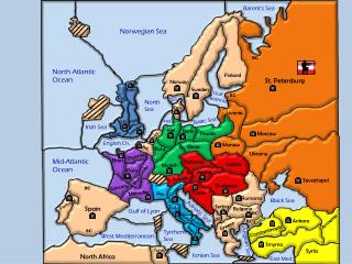
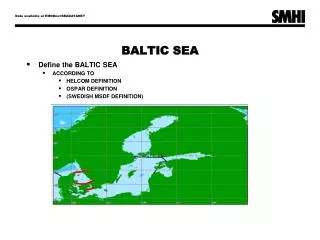
Swedish Coastal Waters some areal facts • Economical zone is about 155 000 km² • Territorial water amounts to about 82 000 km² • European Water Framework Directive (WFD) only contains about 36 000 km² • But the whole Skagerrak, Kattegat and Baltic Sea may be regarded as coastal waters • The length of the Swedish coastline is 11 500 or 32 000 km depending on definition • About 100 000 islands Workshop on The status of European Coastal Observing and Fprecasting Systems, Majorca, October 2007
Swedish Coastal Watersphysical and biological conditions • From an almost oceanic condition in the Skagerrak the salinity decreases to about 1-2 psu in the northern Baltic. • Great spatial and seasonal variation of physical, chemical and biological parameters • Normal condition means that almost half of the Baltic is ice-covered during late winter • The Baltic Sea with its brackish water contains many species that live on their outer edge of survival. • Conditions may get worse as future climate may result in fresher water conditions. Typical salinity in the Baltic Harmful agea blooms during summer Workshop on The status of European Coastal Observing and Fprecasting Systems, Majorca, October 2007
East Gotland basin Skagerrak Bornholm basin Kattegat Increased acidic conditions in the Baltic Sea. Does it depend on increased absorption of atmospheric CO2 ?There is a decrease of pH with about 0.02/10 years in the global seas (IPCC-07) Workshop on The status of European Coastal Observing and Fprecasting Systems, Majorca, October 2007
Regular observations Ships of opportunity Monitoring cruises Ferry-Box Satellite Coastal stations Buoys One-year coverage for a typical year Buoys Water level Added: Real-time and NRT data from all Baltic Sea countries Workshop on The status of European Coastal Observing and Fprecasting Systems, Majorca, October 2007
HOME Water as a complement to traditional monitoringresponds to the Water Framework Directive Workshop on The status of European Coastal Observing and Fprecasting Systems, Majorca, October 2007
The SMHI forecasting system MATCH Ocean data ECMWF HIRLAM • Built on a complete • atmosphere/land/ocean system: • Atmospheric model • Ocean/sea ice model • Open boundary forcing • Data assimilation • Ecological model • Wave model • River runoff model • Atmospheric deposition model • Fine resolution coastal models • Oil spill model Atm. Deposition model Data assimilation River runoff model HIROMB Ecological model Ocean/sea ice model Open boundaries Wave model Workshop on The status of European Coastal Observing and Fprecasting Systems, Majorca, October 2007
Fresh water and nutrients input to the Baltic basinwith an operational river runoff model ~ 1 720 000 km2 Workshop on The status of European Coastal Observing and Fprecasting Systems, Majorca, October 2007
Kernel: HIROMB co-operation Existed for more than ten years Sustainable Contract National funding 9 partners from 8 countries Daily forecast and forcing data 1 nm +48h forecast 3 nm +10 days forecast Freely available on ftp-site Real-time data exchange HIROMB agreement BOOS NOOS Downstream services Oil spill Algea Harbours Sea rescue Sea ice service SMHI consulting Fish and crab larvae Real-time validation and forecasts Freely available on WEB-site www.smhi.se/OceanWeb user:littorina pwd: hermes Workshop on The status of European Coastal Observing and Fprecasting Systems, Majorca, October 2007
HIROMB System Agreement 10 Partners, 9 countries National HELCOM representative Steering Committee On-going projects ECOOP MyOcean Polarview Damocles BANSAI EMAPS Annual Workshop Board Agreed Annual Plan Operational Co-ordinator Scientific Co-ordinator 7d/24h Operational Centre R&D programme Operational models/Data collection/Data dissemination Workshop on The status of European Coastal Observing and Fprecasting Systems, Majorca, October 2007
Forecast and validation on WEB-site OceanWeb sea level currents surface salinity SST and sea ice vertical profiles wind Waves observations R/V Argos observations Workshop on The status of European Coastal Observing and Fprecasting Systems, Majorca, October 2007
Data assimilation • Sea surface temperature Assimilation of a temperature profile. Climatology(top), assimilation using 10 observations (middle) and observed temperature (bottom) Workshop on The status of European Coastal Observing and Fprecasting Systems, Majorca, October 2007
Downstream service: oil spill Fu Shan Hai, June 3, 1200 UTCSeaTrackWeb an internet application Forecast SLAR image At 1018 UTC on Saturday May 31 2003 Fu Shan Hai, fully laden with a cargo of 66,000 metric tonnes of fertiliser loaded in Ventspils, Latvia was struck by a container ship, Gdynia north of Bornholm. . Workshop on The status of European Coastal Observing and Fprecasting Systems, Majorca, October 2007
HIROMB-SCOBI Modelled Chattonella-bloom in Feb 2002 • Left: Surface chlorophyll (mg/m) from satellite Feb 24. • Middle and right: Model results of total chlorophyll and Chattonella concentrations (0-4m depth) from February 2002 24. Workshop on The status of European Coastal Observing and Fprecasting Systems, Majorca, October 2007
Fine-resolution operational local models A fjord in Skagerrak A fine resolution model (60m) together with STW (oil spill drift model) is run operationally. The service is paid by an oil refinery situated in the inner part of the fjord Workshop on The status of European Coastal Observing and Fprecasting Systems, Majorca, October 2007
Conclusions • Observational network needs improvement • satellite data OK for SST and sea ice • not enough data for biological variables • more buoys are needed • a chain of coastal buoys is developing • Upgrading of ocean and ecological model • increased resolution with increased computer capacity • data assimilation will be further developed • a more advanced ecological model is needed Workshop on The status of European Coastal Observing and Fprecasting Systems, Majorca, October 2007