Download
1 / 21
210 likes | 244 Views
Explore the regional planning history, tools, and objectives in Bavaria, including ecological and social structures, infrastructure provisions, population and job growth, nature and landscape protection, agriculture and forestry, industry and commerce, transportation, and environmental protection.

E N D
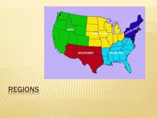
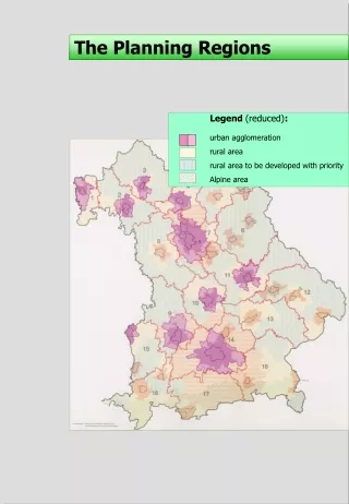
The Planning Regions Legend (reduced): urban agglomeration rural area rural area to be developed with priority Alpine area
The Regional Plan History of regional planning Regional planning in Bavaria • 1973 division into 18 planning regions with the result of the formation of 18 regional planning associations • 1976 beginning of planning Legal base • State-level Planning Act of Bavaria • State-level Nature Conservation Act of Bavaria • State-level Development Program of Bavaria • Planning competence is given to Regional Planning Associations • Technical execution and co-ordination by the Regional Planning Offices
Regional Level Planning Tools The Regional Plan Contents of the regional plan (A) • Part A - inter-disciplinary objectives • I General targets • II Regional structure • 1 Ecological spatial structure • 2 Social and economical spatial structure • 3 Provisions of infrastructure • III Population and jobs • IV Growth axis’s • V Central places • VI Functions of local authorities
Regional Level Planning Tools The Regional Plan Contents of the Regional Plan (B) • Part B- special objectives • I Nature and Landscape • 1 Guidelines of landscape • 2 Protection and development of landscape elements • 3 Biotop management, redevelopment measures • II Settlement • III Agriculture and Forestry • IV Commercial Industry • 1 Regional economic structure • 2 Sectoral economic structure • V Labour market VI Education system VII Social and health essentials IX Transport and communications X Supply of energy XI Water resources management 1 Hydrologic budget 2 Water supply 3 Water conservation XII Environmental protection XIII Defence
Regional Level Planning Tool The Regional Plan Environmental Aspects in Regional Planning • I. Framework of the federal government • Landscape-Program • Framework of regional policy • II. Landscape-Program and State Development Program • 1. Nature and Landscape • - protection of natural resources • - protection of landscape • - development of landscape • 2. Agriculture and forestry • 3. Recreation • 4. Water supply • III. Regional plan of the planning region of Central Franconia • 1. Nature and Landscape • guidelines and objectives of landscape development and protection • protection and development of landscape elements • Regional green belts • preferential landscape areas • nature conservation areas • habitat-management, redevelopment measures • settlement structures
Regional Planning Procedure Regional Planning Association District Government Higher Planning Authority Legal control Sectoral control Department for planning Preparation of regional plan and reports Regional Planning Association Management Chairman chairs chairs chairs Regional Planning Board Organisations of the economic, social and cultural life Planning committee elects elects A s s e m b l y Lord Mayor Chief Admin. Officer Mayor Taluka free Cities Taluka Municipalities The Regional Planning Association includes all communes within its administrative area
Regional Planning Procedure Procedure: Example Bavaria Regional Planning Association Sector Departments Public bodies and others Sector reports Sector Departments Public bodies and others Draft Draft approved by Planning Association Members of Association Regional plan approved by Planning Association Bavarian State Ministry for Regional Development and Environmental Affairs Legalised Regional plan
Regional Planning Procedure Objectives of Regional Planning • Basis for State planning objectives • State Development Programme • Sectoral Framework Plans and Programmes, • e.g. • Project and Infrastructure Plans • Agricultural Orientation Plans • Forest Use Plans • Waste Disposal Plans • Basis for municipal land use planning • Master plan • Legally binding Layout Plan Preparation of Regional Plan • Basis for Spatial Impact Procedure (SIA) • e.g. • Traffic planning • Utility planning • Basis for sectoral planning • e.g. • Planning of child care facilities • Planning of medical supply facilities
The Regional Plan Spatial Structure Legend (reduced): Planning objectives defined by the Regional Plan developing axes of regional importance Informational notification (State Development Programme) urban agglomeration rural space with different objectives for development city of medium importance potential city of central importance (to be developed) developing axes of State importance This plan is signed by the head of the Regional Planning Association!
The Regional Plan Landscape and Recreation Legend (reduced): Planning objectives defined by the Regional Plan Landscape preferential area Banned forest Informational notification (State Development Programme and other plans) Nature Protection Area Settlement (defined by approved master and layout plans) Industrial/Commercial Area Other urban Area This plan is signed by the head of the Regional Planning Association!
The Regional Plan Settlement and Infrastructure Informational notification (State Development Programme and other plans) Airport Federal Highway Natural Gas Pipelines Legend (reduced): Planning objectives defined by the Regional Plan Preferential Area for mineral resources Noise emission zoning to influence land use planning Regional green belt This plan is signed by the head of the Regional Planning Association!
Regional Level Planning Tools The Spatial Impact Assessment Procedure • Scope of the SIA During pre-feasibility stage, large envisioned projects with spatial impacts beyond the local level are already assessed in a single-window licensing procedure. Their spatial impacts are analysed and evaluated on the background of existing co-ordinative and sector plans. Most important aspect: The environmental sensitivity of the selected site and eventual environmental conflicts arising from them.
Regional Level Planning Tools The Spatial Impact Assessment Procedure • Tasks of the SIA • Impacts on other existing projects or land uses • Analysis of the environmental sensitivity of the area affected by the project • Compatibility check whether project is conflicting with spatial objectives and targets of State Development Plans • Co-ordination with other plans
Regional Level Planning Tools The Spatial Impact Assessment Procedure EXAMPLE: HIGHWAY PLANNING • Technical Approach • Multiple Three Tier • Environmental Window Approach: • Sensitivity analysis of the whole region by overlay of 10 themes(maps are existing) • Corridor alignment identification • Identification of best alternative
Regional Level Planning Tools The Spatial Impact Assessment Procedure EXAMPLE: HIGHWAY PLANNING • Procedure • Overall co-ordination: District Government • Technical execution: Highway Authority • Co-ordination with: • Political level • NGO’s • Industry • All planning authorities • Approval: by District Government
Regional Level Planning Tools The Spatial Impact Assessment Procedure • Advantages of the SIA • Single window approach • Early (at pre-feasibility stage) check of possible conflicts • Early co-ordination with all concerned authorities and social groups • Strong emphasis on environmental protection • Effective tool of preventive environmental management
Sectoral Planning - Forest Forest Function Plan Forests with outstanding importance for soil protection and erosion control Forests with importance for avalanche protection Forests with importance for landscape and floodplain Recreational site Forests in urban areas have an outstanding importance for the function of climatic protection and balance Forests on roadsides have an importance for the protection of the road and for the protection (noise and other immissions) of the surroundings 1: 50 000 1: 50 000
Sectoral Planning - Forest Forest Functions Water protection zones are “informationally notified” Groundwater capture areahave an importance for the Forests with outstanding importance for the ecological balance of the landscape (with various signatures) Forests with high recreational function (2 categories) 1: 50 000
Sectoral Planning - Forest Forest Protection Area Plan Forestsed Area of Bavaria (according to the Forest Act) Existing Banned Forests Planned Banned Forests
Sectoral Planning - Water Water Management Framework Plan Flood retention capacity of the floodplain Legend (reduced) Retention ability high Retention ability medium Retention ability low
Sectoral Planning Water Water Management Framework Plan Measures to maintain the wholesomeness of the river system Legend (reduced) Suggestions for Nature Conservation Area Promote extensive agricultural use Suggestion for Landscape Protection Area