Download

1 / 27
270 likes | 435 Views
Strong Polar Anticyclone Activity over the Northern Hemisphere and an Examination of the Alaskan Anticyclone. Justin E. Jones, Lance F. Bosart, and Daniel Keyser Department of Earth and Atmospheric Sciences University at Albany State University of New York.

E N D
Strong Polar Anticyclone Activity over the Northern Hemisphere and an Examination of the Alaskan Anticyclone Justin E. Jones, Lance F. Bosart, and Daniel Keyser Department of Earth and Atmospheric Sciences University at Albany State University of New York 10th Northeast Regional Operational Workshop Albany, NY 5 November 2008 Research supported by NSF Grant ATM-0434189
Goals • Perform an analysis of strong anticyclone activity over the Northern Hemisphere (NH). • Compare the variability in strong anticyclone activity using the NCEP–NCAR and ERA-40 reanalysis datasets. • Create a composite Alaskan anticyclone of individual events to examine large-scale dynamical and thermodynamical processes relevant to its formation and evolution.
Data Sources • ECMWF ERA-40 global reanalysis at 2.5° horizontal resolution - 1 January 1958 – 31 December 2001 • NCEP–NCAR global reanalysis at 2.5° horizontal resolution - 1 January 1948 – 31 December 2007
Methodology: Anticyclone Climatology • An MSLP threshold of 1050 hPa was set at each grid point and a counter was used to sum the number of times the threshold was met or exceeded. • Frequency of occurrence was then contoured objectively based on the number of counts at each grid point. • Full climatology stratified by 10-year periods in the ERA-40 to examine temporal variability on decadal timescales.
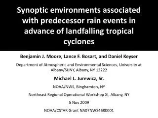
Strong Anticyclone Distribution over the NH NCEP–NCAR 1948 – 2007 MSLP ≥ 1050 hPa Max Count: 2785 Count
Strong Anticyclone Distribution over the NH NCEP–NCAR 1948 – 2007 MSLP ≥ 1050 hPa Max Count: 2785 Count
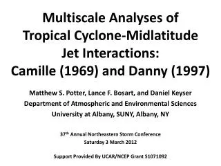
Strong Anticyclone Distribution over the NH ERA-40 1958 – 2001 MSLP ≥ 1050 hPa Max Count: 852 Count
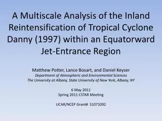
Strong Anticyclone Distribution over the NH ERA-40 1958 – 1967 MSLP ≥ 1050 hPa Max Count: 246 Count
Strong Anticyclone Distribution over the NH ERA-40 1968 – 1977 MSLP ≥ 1050 hPa Max Count: 235 Count
Strong Anticyclone Distribution over the NH ERA-40 1978 – 1987 MSLP ≥ 1050 hPa Max Count: 166 Count
Strong Anticyclone Distribution over the NH ERA-40 1988 – 1997 MSLP ≥ 1050 hPa Max Count: 136 Count
Climatology Summary • Significant interannual and interdecadal variability in both reanalysis datasets • NCEP–NCAR overestimates the number of strong anticyclones over higher terrain features (e.g., Greenland, Tibetan plateau) • Steady decrease in annual maximum 1050 hPa or greater count concentrated over central Asia
Methodology: Alaskan Anticyclone Composite • Subjectively-defined domain over Alaska and extreme northwestern Canada. • Composite of 22 individual events using the ERA-40 dataset which exceeded 1050 hPa within the domain. • Centered on each individual event attaining a 1050 hPa pressure (t = −48 h to t = +48 h). • Examine the development, evolution, and maintenance of the composite anticyclone.
Composite Case List t = 0 h
300 hPa height (solid, dam), wind speed (shaded, m s−1), 300 hPa divergence (negative values dashed, 10−6 s−1) 60 50 40 30 t = −48 h n = 22 MSLP (solid, hPa), 700 hPa geostrophic relative vorticity (shaded, 10−5 s−1), 1000–500 hPa thickness (dashed, dam)
300 hPa height (solid, dam), wind speed (shaded, m s−1), 300 hPa divergence (negative values dashed, 10−6 s−1) 60 50 40 30 t = −24 h n = 22 MSLP (solid, hPa), 700 hPa geostrophic relative vorticity (shaded, 10−5 s−1), 1000–500 hPa thickness (dashed, dam)
300 hPa height (solid, dam), wind speed (shaded, m s−1), 300 hPa divergence (negative values dashed, 10−6 s−1) 60 50 40 30 t = 0 h n = 22 MSLP (solid, hPa), 700 hPa geostrophic relative vorticity (shaded, 10−5 s−1), 1000–500 hPa thickness (dashed, dam)
300 hPa height (solid, dam), wind speed (shaded, m s−1), 300 hPa divergence (negative values dashed, 10−6 s−1) 60 50 40 30 t = +24 h n = 22 MSLP (solid, hPa), 700 hPa geostrophic relative vorticity (shaded, 10−5 s−1), 1000–500 hPa thickness (dashed, dam)
300 hPa height (solid, dam), wind speed (shaded, m s−1), 300 hPa divergence (negative values dashed, 10−6 s−1) 60 50 40 30 t = +48 h n = 22 MSLP (solid, hPa), 700 hPa geostrophic relative vorticity (shaded, 10−5 s−1), 1000–500 hPa thickness (dashed, dam)
t = −24 h n = 22 Below: 700 hPa height (solid black, dam), 700 hPa temperature (dashed blue, K), and vertical motion (positive values shaded, 10−3 hPa s−1) A’ A A’ Above: Cross section of potential temperature (solid black, K), vertical motion (positive values solid red, 10−3 hPa s−1), and winds (knots) H A
t = 0 h n = 22 Below: 700 hPa height (solid black, dam), 700 hPa temperature (dashed blue, K), and vertical motion (positive values shaded, 10−3 hPa s−1) A’ A A’ Above: Cross section of potential temperature (solid black, K), vertical motion (positive values solid red, 10−3 hPa s−1), and winds (knots) H A
t = +24 h n = 22 Below: 700 hPa height (solid black, dam), 700 hPa temperature (dashed blue, K), and vertical motion (positive values shaded, 10−3 hPa s−1) A A’ A’ Above: Cross section of potential temperature (solid black, K), vertical motion (positive values solid red, 10−3 hPa s−1), and winds (knots) H A
t = +48 h n = 22 Below: 700 hPa height (solid black, dam), 700 hPa temperature (dashed blue, K), and vertical motion (positive values shaded, 10−3 hPa s−1) A A’ A’ Above: Cross section of potential temperature (solid black, K), vertical motion (positive values solid red, 10−3 hPa s−1), and winds (knots) H A
Alaskan Composite Summary • Strong amplification of the upper ridge upstream of the surface anticyclone between t = −24 h and t = +24h. • Upper-level convergence and advection of anticyclonic geostrophic relative vorticity by the thermal wind (TW) over the center of the surface anticyclone act to rapidly intensify it between t = 0 h and t = +24h. • Composite anticyclone reaches maximum intensity (1049 hPa) at t = +24 h. • Anticyclone elongates southeastward along the eastern slope of the Rockies between t = +24 h and t = +48 h.
Conclusions • ERA-40 outperforms NCEP–NCAR in representing the number of strong anticyclones over higher terrain. • Strong anticyclone (1050 hPa or greater) frequency is declining at a rate of approximately 3–4 counts per decade over central Asia. • The strong Alaskan anticyclone is tropospheric deep and dynamically forced. • Convergence in upper troposphere • Advection of geostrophic relative vorticity by TW in the mid-troposphere