Download
1 / 24
240 likes | 385 Views
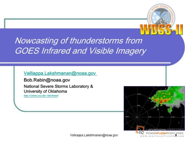
Nowcasting of thunderstorms from GOES Infrared and Visible Imagery. Valliappa.Lakshmanan@noaa.gov Bob.Rabin@noaa.gov National Severe Storms Laboratory & University of Oklahoma http://cimms.ou.edu/~lakshman/. Nowcasting Thunderstorms From Infrared and Visible Imagery.

E N D
Nowcasting of thunderstorms from GOES Infrared and Visible Imagery Valliappa.Lakshmanan@noaa.gov Bob.Rabin@noaa.gov National Severe Storms Laboratory & University of Oklahoma http://cimms.ou.edu/~lakshman/ Valliappa.Lakshmanan@noaa.gov
Nowcasting Thunderstorms From Infrared and Visible Imagery Tracking Storms: Existing Techniques Overview of Method Identifying Storms at Multiple Scales Motion Estimation and Forecast Valliappa.Lakshmanan@noaa.gov
Methods for estimating movement • Linear extrapolation involves: • Estimating movement • Extrapolating based on movement • Techniques: • Object identification and tracking • Find cells and track them • Optical flow techniques • Find optimal motion between rectangular subgrids at different times • Hybrid technique • Find cells and find optimal motion between cell and previous image Valliappa.Lakshmanan@noaa.gov
Some object-based methods • Storm cell identification and tracking (SCIT) • Developed at NSSL, now operational on NEXRAD • Allows trends of thunderstorm properties • Johnson J. T., P. L. MacKeen, A. Witt, E. D. Mitchell, G. J. Stumpf, M. D. Eilts, and K. W. Thomas, 1998: The Storm Cell Identification and Tracking Algorithm: An enhanced WSR-88D algorithm. Weather & Forecasting, 13, 263–276. • Multi-radar version part of WDSS-II • Thunderstorm Identification, Tracking, Analysis, and Nowcasting (TITAN) • Developed at NCAR, part of Autonowcaster • Dixon M. J., and G. Weiner, 1993: TITAN: Thunderstorm Identification, Tracking, Analysis, and Nowcasting—A radar-based methodology. J. Atmos. Oceanic Technol., 10, 785–797 • Optimization procedure to associate cells from successive time periods • Satellite-based MCS-tracking methods • Association is based on overlap between MCS at different times • Morel C. and S. Senesi, 2002: A climatology of mesoscale convective systems over Europe using satellite infrared imagery. I: Methodology. Q. J. Royal Meteo. Soc., 128, 1953-1971 • http://www.ssec.wisc.edu/~rabin/hpcc/storm_tracker.html • MCSs are large, so overlap-based methods work well Valliappa.Lakshmanan@noaa.gov
Some optical flow methods • TREC • Minimize mean square error within subgrids between images • No global motion vector, so can be used in hurricane tracking • Results in a very chaotic wind field in other situations • Tuttle, J., and R. Gall, 1999: A single-radar technique for estimating the winds in tropical cyclones. Bull. Amer. Meteor. Soc., 80, 653-668 • Large-scale “growth and decay” tracker • MIT/Lincoln Lab, used in airport weather tracking • Smooth the images with large elliptical filter, limit deviation from global vector • Not usable at small scales or for hurricanes • Wolfson, M. M., Forman, B. E., Hallowell, R. G., and M. P. Moore (1999): The Growth and Decay Storm Tracker, 8th Conference on Aviation, Range, and Aerospace Meteorology, Dallas, TX, p58-62 • McGill Algorithm of Precipitation by Lagrangian Extrapolation (MAPLE) • Variational optimization instead of a global motion vector • Tracking for large scales only, but permits hurricanes and smooth fields • Germann, U. and I. Zawadski, 2002: Scale-dependence of the predictability of precipitation from continental radar images. Part I: Description of methodology. Mon. Wea. Rev., 130, 2859-2873 Valliappa.Lakshmanan@noaa.gov
Need for hybrid technique • Need an algorithm that is capable of • Tracking multiple scales: from storm cells to squall lines • Storm cells possible with SCIT (object-identification method) • Squall lines possible with LL tracker (elliptical filters + optical flow) • Providing trend information • Surveys indicate: most useful guidance information provided by SCIT • Estimating movement accurately • Like MAPLE • How? Valliappa.Lakshmanan@noaa.gov
Nowcasting Thunderstorms From Infrared and Visible Imagery Tracking Storms: Existing Techniques Overview of Method Identifying Storms at Multiple Scales Motion Estimation and Forecast Valliappa.Lakshmanan@noaa.gov
Technique: Stages • Clustering, tracking, interpolation in space (Barnes) and time (Kalman) Courtesy: Yang et. al (2006) Valliappa.Lakshmanan@noaa.gov
Technique: Details • Identify storm cells based on reflectivity and its “texture” • Merge storm cells into larger scale entities • Estimate storm motion for each entity by comparing the entity with the previous image’s pixels • Interpolate spatially between the entities • Smooth motion estimates in time • Use motion vectors to make forecasts Courtesy: Yang et. al (2006) Valliappa.Lakshmanan@noaa.gov
Why it works • Hierarchical clustering sidesteps problems inherent in object-identification and optical-flow based methods Valliappa.Lakshmanan@noaa.gov
Advantages of technique • Identify storms at multiple scales • Hierarchical texture segmentation using K-Means clustering • Yields nested partitions (storm cells inside squall lines) • No storm-cell association errors • Use optical flow to estimate motion • Increased accuracy • Instead of rectangular sub-grids, minimize error within storm cell • Single movement for each cell • Chaotic windfields avoided • No global vector • Cressman interpolation between cells to fill out areas spatially • Kalman filter at each pixel to smooth out estimates temporally Valliappa.Lakshmanan@noaa.gov
Nowcasting Thunderstorms From Infrared and Visible Imagery Tracking Storms: Existing Techniques Overview of Method Identifying Storms at Multiple Scales Motion Estimation and Forecast Valliappa.Lakshmanan@noaa.gov
K-Means Clustering • Contiguity-enhanced K-Means clustering • Takes pixel value, texture and spatial proximity into account • A vector segmentation problem • Hierarchical segmentation • Relax intercluster distances • Prune regions based on size Valliappa.Lakshmanan@noaa.gov
Example: hurricane on radar (Sep. 18, 2003) Image Scale=1 Eastward s.ward Valliappa.Lakshmanan@noaa.gov
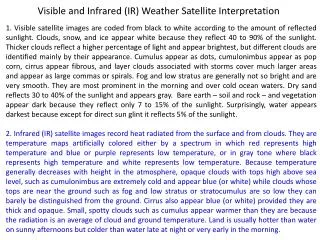
Satellite Data • Technique developed for radar modified for satellite • Funding from NASA and GOES-R programs • Data from Oct. 12, 2001 over Texas • Visible • IR Band 2 • Because technique expects higher values to be more significant, the IR temperatures were transformed as: • Termed “CloudCover” • Would have been better to use ground temperature instead of 273K • Values above 40 were assumed to be convective complexes worth tracking • Effectively cloud top temperatures below 233K C = 273 - IRTemperature Valliappa.Lakshmanan@noaa.gov
Segmentation of infrared imagery Not just a simple thresholding scheme Coarsest scale was used because 1-3 hr forecasts desired. Valliappa.Lakshmanan@noaa.gov
Nowcasting Thunderstorms From Infrared and Visible Imagery Tracking Storms: Existing Techniques Overview of Method Identifying Storms at Multiple Scales Motion Estimation and Forecast Valliappa.Lakshmanan@noaa.gov
Motion Estimation • Use identified storms in current image as template • Move template around earlier image and find best match • Match is where the absolute error of difference is minimized • Not root mean square error: MAE is more noise-tolerant • Minimize field by weighting pixel on difference from absolute minimum • Find centroid of this minimum “region” • Interpolate motion vectors between storms Valliappa.Lakshmanan@noaa.gov
Processing Clustering, Motion estimation IR to CloudCover Motion estimate applied to IR and Visible Valliappa.Lakshmanan@noaa.gov
Forecast Method • The forecast is done in three steps: • Forward: project data forward in time to a spatial location given by the motion estimate at their current location and the elapsed time. • Define a background (global) motion estimate given by the mean storm motion. • Reverse: obtain data at a spatial point in the future based on the current wind direction at that spot and current spatial distribution of data. Valliappa.Lakshmanan@noaa.gov
Forecast Example (IR, +1hr, +2hr, +3hr) Valliappa.Lakshmanan@noaa.gov
Forecast Example (Visible, +1hr, +2hr, +3hr) Varying intensity levels are a problem Valliappa.Lakshmanan@noaa.gov
Skill compared to persistence Valliappa.Lakshmanan@noaa.gov
Conclusions • Advection forecast beats persistence when storms are organized • Does poorly when storms are evolving • IR forecasts are skilful • Visible channel forecasts are not Valliappa.Lakshmanan@noaa.gov