Download

1 / 26
260 likes | 280 Views
The Coast Guard Navigation Center ensures safe waterway transportation by supporting navigation systems and providing timely waterways information services. Learn about operational sites, partner organizations, coverage planning, and progress updates.

E N D
NAVCEN Mission Statement • The Coast Guard Navigation Center promotes safe, secure, and efficient transportation on United States’ waterways by providing: • Operational and technical support for electronic navigation systems • Quality positioning, navigation and timing signalsLORAN NDGPS DGPS NAIS • Accurate and timely waterways information services.
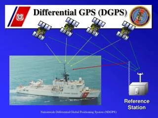
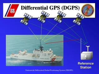
Maritime / Nationwide DGPS Currently 86 operational sites: USCG NAVCEN is the Operational Control for all sites. Newly commissioned Maritime Information Operations Center (MIOC) Nationwide DGPS Partnership: USCG Maritime 39 sites Dept of Transportation 38 sites U. S. Army Corps of Engineers 9 sites
USCG Maritime Signal Coverage • USCG funds & maintains 39 sites. - Maritime navigation and ATON Positioning
US Army Corps of Engineers Signal Coverage • US Army Corps of Engineers funds & maintains coverage for Inland Waterways • Surveying and Dredging • Setting Navigational Aids • Electronic Navigation
US Department of Transportation’s Nationwide DGPS Coverage • US Dept of Transportation funds 38 sites which are operated & maintained by the USCG and contract support. • Precision Agriculture, Intelligent Transportation Systems,Positive Train Control. Slide 8
Nationwide DGPS Coverage Planning & Verification
N/DGPS Project Status Report
Nationwide Single Coverage Goal Sites Required for the 98% Single Coverage Goal • Sage Junction, ID (New Build) • Marshall, TX (New Build) • Big Lake, TX (New Build) • Patten, ME (New Build) • St. Mary's, WV (New Build) • Bliss, ID (New Build) • Tucson, AZ (New Build) • Carlsbad, NM (New Build)
NDGPS Coverage 98% Coverage
Find a Candidate Property Conduct a Site Assessment Complete an Environmental Investigation under the guidelines of the Programmatic EA (FONSI) Complete a Real Property Survey - Includes Soil Boring Samples Complete the Installation Design Plan Complete the Property Use Agreement (Lease/Purchase/ISSA) Site Preparation Procedures
NDGPS FY08 Progress • Bliss, ID (AKA Gooding New Build) • Site Assessment Completed • Property Survey Completed • SF299 RP Document In Progress (BLM Property) • EA Underway Through FHWA • IDP Pending (ETC: August 2008) • Tucson, AZ (New Build) • Site Assessment Completed • Property Survey Completed • SF299 RP Document In Progress(BLM Property) • EA Underway Through FHWA (ETC: Nov 2008) • IDP Pending (90% Complete, Awaiting EA)
NDGPS FY08 Progress • Carlsbad, NM (New Build) • Site Assessment Completed • Property Survey Completed • SF299 RP Document In Progress (BLM Property) • EA Underway Through FHWA (ETC: Nov 2008) • IDP Package Completed • Additional Items: • Archaeological Survey sent to Native American tribes 25 Jan 08. • Public Workshop Completed • Sage Junction, ID (AKA Idaho Falls New Build) • Site Assessment Completed • Property Survey Completed • Lease Negotiations Pending • EA Underway Through FHWA (ETC: Jun 2009) • IDP Pending Results Of The EA
NDGPS FY08 Progress • St Marys, WV (New Build) • All Preparations Completed • Site Ready For Construction (AUG 11th- SEP 26th) • SOVT (SEP 29th – OCT 3rd) • Marshall, TX (New Build) • Site Assessment Completed • Property Survey Completed • EA Completed • IDP Completed • Lease Negotiations Pending
NDGPS FY08 Progress • Big Lake, TX (New Build) • Site Assessment Completed • Property Survey Completed • EA is Underway Through the FHWA • IDP Completed • Lease Negotiations Pending Results of the EA • Georgetown, TX (New Build) • Site Assessment Completed • Property Survey Completed • EA Completed • IDP Completed • Lease Negotiations Pending
Maritime DGPS Progress FY08 • Card Sound, FL (Miami Replacement & New Build) • All Preparations Completed • Awaiting Frame Relay (FR) Circuit Delivery • NAVCEN Requesting Onsite Survey Through Provider • SFWMD Permit Received • - Zoning Letter for Class 4 Miami Dade County Permit • Eglin AFB, FL (Mobile Point Replacement & New Build) • Site Assessment Completed • Property Survey Completed • Interference Study (IS) Requested by USAF • EA Pending Commencement (IS) • IDP Pending EA • Lease Pending/Construction Pending Clearance of County Permits
Maritime DGPS Progress FY08 • Salinas, PR (New Build) • Site Assessment Completed • Property Survey Completed • Interference Study (IS) Requested by USAF • EA Pending Commencement (IS) • IDP Pending EA • Lease Pending
Maritime DGPS Recap Upgraded Receivers & Antennas: L1/L2 (L2C) Geodetic Grade Accuracy is typically 1-3 meters (10 meters published) Much better accuracy has been observed from prototype recap sites. Testing is in progress to determine typical accuracy measurements. New system architecture is easier and less expensive to upgrade as new technologies become available. 22 Slide 22
Engineering Upgrades RS/IM RECAP (CRIA)RTCI UPGRADE SITE DATE OF INSTALL SITE DATE OF INSTALL Driver, Virginia 31-Jan-2008 Greensboro, North Carolina 14-Mar-2005 New Bern, North Carolina 19-Feb-2008 Macon, Georgia 06-Apr-2005 Kensington, South Carolina 22-Feb-2008 Hudson Falls, New York 01-May-2008 Tampa, Florida 07-Mar-2008 Dandridge, Tennessee 08-May-2008 Aransas Pass, Texas 21-Mar-2008 Flagstaff, Arizona 04-Jun-2008 English Turn, Louisiana 18-Mar-2008 Albuquerque, New Mexico 10-Jun-2008 Angleton, Texas 03-Apr-2008 Moriches, New York 07-Apr-2008 Cape Canaveral, Florida 04-Mar-2008 Reedy Point, Delaware 29-Apr-2008 Lompoc, California 06-May-2008 Cape Mendocino, California 14-May-2008 Tamp, Florida 20-May-2008 Wisconsin Point, Wisconsin 18-Jun-2008 Gustavus, Alaska 18-Jun-2008 Biorka Island, Alaska 25-Jun-2008 Brunswick, ME 09-Jul-2008 Pickford, MI 23-Jul-2008
LCDR Jacob Ramos Jacob.J.Ramos@uscg.mil 703-350-7126 Cell 703-313-5858 Work