Download
1 / 17
170 likes | 430 Views
NTRIP-based DGPS service in Hungary. Tam á s Horv á th FÖMI Satellite Geodetic Observatory Penc, Hungary. The Satellite Geodetic Observatory. Department of the Institute of Geodesy, Cartography and Remote Sensing (FÖMI) Established in 1969 Located in Penc, Hungary

E N D
NTRIP-based DGPS service in Hungary Tamás Horváth FÖMI Satellite Geodetic Observatory Penc, Hungary
The Satellite Geodetic Observatory • Department of the Institute of Geodesy, • Cartography and Remote Sensing (FÖMI) • Established in 1969 • Located in Penc, Hungary • (40 km NE of Budapest) • Space geodetic research, • technology and know-how transfer • Active GPS network development • International EUREF analysis • centre (24 stations) • GPS levelling and • crustal movement monitoring • EUPOS® participant since 2002 • NtripCaster operator since 2004 • GNSS Service Centre established in 2004 • EUPOS® National Competence Centre
Contents • Network configuration • Data dissemination • Services • Accuracy • User community • Further development
Existing Reference Station Network NYIR PENC CSOR BUTE SZFV ZALA KECS OROS KAPO 50 km 100 km
The TAKARNET Network • Intranet network connecting 117 Hungarian Land Registry offices • Designed for cadastre data exchange • Central unit located at the FÖMI headquarters in Budapest • The Satellite Geodetic Observatory is also an endpoint of TAKARNET • Bandwidth: 256-448/128 kbps
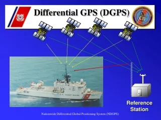
Reference Station and Network Control Centre GPS antenna Ntrip monitoring PCs, Rack with Internet routers GPS receiver, PC running reference station sw, UPS NtripCaster, Webserver, Data processing PCs
RTCM Data Broadcasting Ref. station 1 Ref. station 2 Ref. station 3 . . . Takarnet/Internet HTTP Streams GPRS/Internet HTTP Streams NtripCaster User Segment Ref. station n www.gpsnet.hu:2101 82.131.181.15:2101
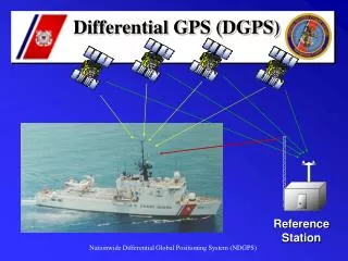
Services • RTK corrections • (RTCM 2.1 Message Types 3, 20/21) 1-5 cm accuracy • DGPS corrections • (RTCM 2.1 Message Types 1, 2, 3) submetre accuracy • EGNOS ESTB VRS corrections • (RTCM 2.1 Message Types 1, 2, 3) for testing only, intermittent • RINEX data (hourly and daily files) for post-processing • GPS equipment calibration • Support during normal working hours
GPRS/RTK Test in Budapest Combined GPS receiver & antenna communication Controller with integrated NtripClient and GIS functionality
RTK Accuracy (10 km baseline, GPRS) 0.009 m (1σ) 0.010 m (1σ) 0.016 m (1σ)
User Community • Cadastre management • Area-based EU agricultural subsidy control • Precision agriculture • Land surveying • GIS (e.g. public utility management) • Traffic and transportation management • Motorway/railway and bridge construction • Machine guidance • Environmental protection • Natural disaster management • Security services • Hidrography • Forestry • Archaeology • Universities & research institutes • Etc.
Further Development • 2005 • 3 new stations to be deployed around Budapest • Network RTK software to be installed at the NCC • Homogeneous RTK coverage for greater Budapest • Monitoring system to be developed • Extended testing and demonstrations • 2006 – 2007 • Network densification 25 – 30 reference stations • Infrastructure development financed by the state budget • and by EU and bilateral projects • Homogeneous RTK coverage for the whole country • Real-time service charges to be introduced • Supporting application development
Network Upgrade Phase A (2005) Network Upgrade Phase B (2006 - ) KISV OZDI SZER NYIR FUZE PENC HAJD CSOR TATA BUTE JASZ MONO PUSP SZOM SZFV BERE AJKA MEZO SIOF ZALA KECS BEKE PAKS OROS KANI KAPO KISK SZEG 50 km 100 km BAJA PECS
New Services to be introduced • Real-time correction data: • RTCM-EU (EUPOS® format using FKP) • VRS corrections (RTCM 2.1 Message Types 20/21) • Data for post-processing: • (>)1Hz RINEX files • Rover receivers for rent • Training courses for end users and state officials • RINEX data processing service • Extended support
Acknowledgement • The Hungarian DGPS network development is supported by the following projects: • Ministry of Economy and Transport (GKM) GVOP-3.1.1.-04- 0001/3.0 • Hungarian Space Office (MŰI) TP-145
Thank you for your attention! • Further Information: • Web: www.sgo.fomi.hu, www.gpsnet.hu • E-mail: info@gpsnet.hu • Phone: +36 27 374 980