JTWC SATOPS Challenges
JTWC SATOPS Challenges. Capt Kathryn Payne 28 April 2009 . Overview. JTWC as an operational center Dvorak Weaknesses Case study 15W (Sinlaku) 2008 Intensity Estimates for Developing Storms Subtropical/Extratropical storms Case study 27W (Haiyan) 2007.

JTWC SATOPS Challenges
E N D
Presentation Transcript
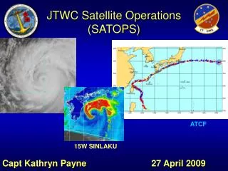
JTWC SATOPSChallenges Capt Kathryn Payne 28 April 2009
Overview • JTWC as an operational center • Dvorak Weaknesses • Case study 15W (Sinlaku) 2008 • Intensity Estimates for Developing Storms • Subtropical/Extratropical storms • Case study 27W (Haiyan) 2007
JTWC as an Operational Forecast Center • JTWC’s primary customer is DoD (also support NWS Guam) • Supporting operations is top priority • Operational support for Subtropical/Extratropical systems done by NMFC (with JTWC Coordination) • 89% of TCs occur in JTWC’s AOR • Due to Southern Hemisphere/ North IO responsibility, JTWC is busy all year around (no off-season) • Watch run by 1 TDO + 1 Satellite Analyst • Limited resources for both operations and transition of research to operations • JTWC “Request for Evaluation” form
Dvorak Technique • Due to lack of aircraft recon, Dvorak primary tool for intensity estimates • Known weaknesses in Dvorak present problems for TDO/analyst • Few updates to process in 30 years • Subjectivity • Rapid intensification • Weakening systems • Weak, developing systems • Midgets/pinhole eye • Dvorak advantages • Understandable, repeatable process • Can be performed “around the clock”- IR (BD) imagery • Worldwide standard • Weaknesses, though present, are known
15W- SinlakuRapid Intensification south of Japan 0530Z 3.0/3.0 (45 kts) 0830Z 3.0/3.0 (45 kts) 1130Z 3.0/3.0 (45 kts) 1430Z 3.0/3.0 (45 kts) Aircraft obs: 979 mb 81 kt FL WIND Blind Dvorak assessment .5 T# higher Eye fix or wrap? 1730Z 2.5/3.0 (45 kts) 2030Z 2.5/3.0 (45 kts) 2330Z 4.0/4.0 (65 kts)
Developing Storms • Dvorak starts at 25 kts=warning criteria for West Pac • Wide range of Dvorak 1.0 estimates what does a 1.0 mean for the TDO? • Scatterometry an option, but not always available • Ambiguities hold promise, but we need improved understanding and a repeatable process
1.0 Dvorak = 25 ktsLarge variance of appearance in microwave Best track: 20kts JTWC: 1.0/1.0 Best track: 15kts JTWC: 1.0/1.0 Best track: 25kts JTWC: 1.0/1.0 Best track: 20kts JTWC: 1.0/1.0 Best track: 15 kts JTWC: 1.0/1.0 Best track: 30kts JTWC: 1.0/1.0 Best track: 20kts JTWC: 1.0/1.0 KNES: 1.5/1.5 Best track: 15kts JTWC: 1.0/1.0 KNES: 1.5/1.5
Subtropical Systems • Less common than in Atlantic, so analysts have less experience • Still using Hebert-Poteet method to estimate intensity (along with scat data) • JTWC does not typically warn on ST (unlike NHC.) May choose to warn based on operational concerns • Some ST transition to tropical • JTWC has been working to gain better understanding of these storms
Subtropical Systems • 27W (Haiyan) from Oct 07 • JTWC did not warn, as it was assessed to be ST • Dvorak estimates were not representative of quikscat winds/ship obs • Later examination of products indicated storm developed upper level warm core • In 2007 ATCR, JTWC reclassified as a TC (27W) • Highlighted the need for improved knowledge of subtropical systems • Spurred increase use of AMSU-A products to assess thermal structure
Extratropical Transition • As a TC transitions to Extratropical, warning responsibility transfers from JTWC to NMFC • SATOPS uses Lander’s XT technique to fix • Often use of this technique creates a “jump” in intensity when transitioning from tropical to XT • Not always clear when a TC has transitioned to XT • Hard to determine warm core vs. cold core from satellite imagery • AMSU-A can help/cyclone phase (model data) • Improvements desired
SATOPS Contacts • OIC – Capt Kathryn Payne Capt Stephen Chesser (Aug 09) • NCOIC – TSgt Ken Viault • E-Mail: firstname.lastname@navy.mil • Duty Satellite Analyst: • Commercial: (808) 471-3533 • DSN: (315) 471-3533 • SATOPS Office: • Commercial: (808) 474-3946 • DSN: (315) 474-3946