Download
1 / 54
540 likes | 553 Views
Learn about the Pennsylvania Spatial Data Access (PASDA) model, data formats and options, software, data management, sharing, preservation, and the wide range of services offered. Discover its importance to the commonwealth and how PASDA supports users and providers.

E N D
Pennsylvania Spatial data access User feedback session presentation
Session Overview • PART I: Introduction & Overview • The PASDA Model, PASDA Statistics, PASDA Users & Providers • PART II: Data • Available Data, Data Formats & Options, Software, Data Management, Data Sharing, Data Preservation • PART III: Services • Website, Applications, Services • PART IV: Vision & Wrap Up
Introductions • Please introduce yourself.
PASDA Staff • Maurie Kelly • James Spayd • Ryan Baxter • Scott Dane • Approximately 2.75 staff manage PASDA
Pasda Basics • Pennsylvania Spatial Data Access (PASDA) is Pennsylvania's official public access geospatial information clearinghouse. • PASDA was developed in 1996 by the Pennsylvania State University and has served as the clearinghouse for Pennsylvania for over twenty one years. • PASDA is a cooperative project of the Governor's Office of Administration, Office for Information Technology, and Penn State Institutes of Energy and the Environment of the Pennsylvania State University. • Funding is provided by the Pennsylvania Office for Information Technology. • Penn State provides significant contributions to PASDA including system administration support and infrastructure from the Institute for CyberScience, and the College of Earth and Mineral Sciences.
Why is PASDA Important to the commonwealth? • The purpose of PASDA is to serve as the Commonwealth's comprehensive and coordinated free public access open geospatial data portal. • Maintaining PASDA as a coordinated and comprehensive open data portal: • Eliminates the creation of Data Silos that can frustrate users. • Fosters coordination and cooperation. • Streamlines easy access to a broad range of data. • Enables data management throughout the data life cycle. • Closes the loop by archiving and preserving data for the long term. • Provides a point of contact for users and providers.
The PASDA Model • The PASDA Model is unique among data portals.
The PASDA Model: Open to multiple data providers • Any state, local, regional or federal government, non governmental organization, or academic institution can freely share its geospatial data through PASDA. • Why?
The PASDA Model: Data curation and access • PASDA is not just a pass through to access data. • PASDA’s mission is to curate data. • What is the difference?
The PASDA Model: Data Curation and access • Data curation is the management of data throughout its lifecycle from initial publication and storage to the time when it is archived for posterity. • We ensure that data is available today and tomorrow so that the value of the data is maintained over time, and the data remains available for use, reuse, and preservation. • We ensure that data from multiple sources are integrated into a coordinated, searchable, authoritative system that will provide access for the long term.
The PASDA Model: Data Curation AND Access • Our methodology includes: • Acquiring data from authoritative sources. • Testing the data. Is it complete, usable? • Annotating (documenting via the development of metadata) the data according to international metadata standards. • Publish the data in multiple formats to accommodate the widest possible group of users. This also allows users to “add value” to the data by integrating it into their workflows, projects, applications, and programs. • Developing search and retrieval capabilities that allow users to easily find data. • Creating applications that provide quick and easy access to data collections (e.g., the PA Imagery Navigator, PA Mine Map Atlas) • Backing up data to near line data storage. • Archiving data to dark storage using the same methodology used by the Library of Congress. • Creating persistent identifiers for data so users can reference the data easily.
The PASDA model: user support • PASDA staff are available to respond to a wide array of questions-–from how to use data to data creation methodologies to how to use the site. • PASDA staff are on-hand to provide a direct point-of-contact and timely response to communications from users. • User support includes responding to inquiries from users via email, phone and in person. • PASDA responds to more than 5,000 user requests per year. • We are always there for our providers and our users.
The pasda model: widespread integration • PASDA allows other data portals to “harvest” metadata allowing the data holdings on PASDA to be published in other data portals such as the National States Geographic Information Council (NSGIC) GIS Data Inventory, Data.gov, and via ArcGIS Online where PASDA has maintained its organizational presence since 2000 (with the development of the forerunner of AGOL, The Geography Network).
PASDA Model: Engagement • PAMAP • PennPilot • Flood Mitigation/Flood Insurance • Mine Subsidence Insurance • PEMA Imagery Acquisition Project • Delaware River Watershed Initiative • PASDA serves on the PA Open Data Advisory Committee. • Developed tutorials to assist users who are interested in learning more about GIS and using PASDA. • We meet with state agencies, local, and regional governments, schools, and other institutions to provide guidance and information on managing geospatial data and metadata.
PASDA Model: Engagement • Central PA GIS Day (exhibit, presented, committee) • NW PA GIS Conference (exhibit, presented) • PA GIS Conference (exhibit, presented, committee) • PA Open Data Portal (Advisory Committee) • PA GeoBoard (board member, task force member) • PA EnerGIS (presented) • PA Land Surveyors Association (presented) • Library of Congress/Federal Geographic Data Committee GIS Data Preservation Committee (member) • We have also supported the efforts of many organizations and projects including the Delaware River Watershed Initiative, the USGS National Biological Information Infrastructure, Ohio Headwaters Initiative, Pennsylvania Organization for Watersheds and Rivers, Explore PA History, PAView, Chesapeake Bay Program.
PASDA Architecture • PASDA stores more than 100 Terabytes of data and provides access to more than 450,000 data sets. • (Note: This does not include the Statewide Imagery Cache(this data is only available for use via a map service or for viewing via the PA Imagery Navigator) which consists of more than1.2 million images. • PASDA works with two organizations at Penn State to store and provide access to the data.
PASDA architecture: ICS-ACI • Institute for CyberScience Advanced Computing Infrastructure (ICS-ACI) provides a High Performance Storage Archive (ACI-HPSA) capability for PASDA. • The ACI-HPSA infrastructure includes clustered file systems that interconnect across high speed Ethernet, Infiniband, and Fibre Channel network fabrics. • They provide active storage, near-line storage pools that provide a long-term data storage and back up and an archive storage repository. • They also provide system administration and support for PASDA.
PASDA architecture: Earth and Mineral Sciences Computing • The EMS High Performance Computing Facility houses PASDA’s web servers and provides system administration support for PASDA.
Stats • Overview FY 2016/2017 Statistics: • PASDA Hits: 126,280,340 • Page Views: 75,620,157 • PASDA Unique Visitors: 1,365,568 • Datasets Downloaded: 2,727,925 (Up by 300,000 downloads since last year!) • Map Services Requested (APIs, KMLs, WMS, REST): 93,994,812 • Pennsylvania Imagery Navigator: 5,456,183
stats • 19,000+ downloads DEP data • 5 million+ uses of the DEP map service • 17,000 downloads of PennDOT data • Almost 2 million uses of the PennDOT map service • 1.2 million+ uses of the PA Fish and Boat Commission map service • 30,000+ downloads Lancaster County data • 600,000 uses of the Lancaster County map service
PASDA Users • PA Governments: State, County, Municipal, Regional • Federal Government Agencies: EPA, FEMA, US Army Corps, Homeland Security, National Weather Service, Army Corps, Transportation. • Emergency Responders, Police Departments, Local and Regional Hospitals • Non Profit Organizations: Conservancies, Watershed Organizations, Social Service Support Organizations • Conservation Districts • Surveyors • K-12 Schools and Higher Education • Business and Industry: Engineering, Surveying, Utilities, Engineers, Architects, Developers, Environmental Management, Real Estate, Transportation, Marketing and Advertising, GIS Consulting Firms, Architects • Pennsylvania citizens
Questions Part i • Our first questions for you center on who you are and how you use GIS data. • We are also interested in how often and how you access PASDA. • And finally, we ask that you take a moment to reflect on anything new you might have learned in the first part of our discussion.
Data • PASDA provides access to data from all levels of government, non profits (NGOs), academic institutions, and more. • We have data from providers such as PA DEP, PennDOT, and City of Philadelphia from the mid to late 1990s. • PASDA stores and provides access to all of the PAMAP and PennPilot data, multiple years of aerial photography (and some LIDAR and elevation products) from providers such as Allegheny County, City of Philadelphia, Delaware Valley Regional Planning Commission, Lehigh Valley Planning Commission, York County, Lancaster County, USGS, NAIP (USDA), NGA, and the PA Sea Grant Consortium.
data • We also provide access to unique data such as the underground mine maps from PA DEP and from diverse organizations like the Eastern PA Coalition for Abandoned Mine Reclamation, the Natural Lands Trust, the Susquehanna River Basin Commission and Delaware River Basin Commission, and the University of Vermont Spatial Analysis lab (land use/land cover data for PA, PA Counties, and Chesapeake Bay region).
Data formats • PASDA provides access to data in multiple formats including: • Shapefile • Geodatabase • JSON • CSV • KML • Map services (API, REST, WMS) • Data Previews
Barriers to Data Sharing • It is easy to share data via PASDA. • However, there are barriers to sharing data in general. • Barriers include concerns about: • liability concerns • funding and support—GIS data can generate income • control
Questions part ii: Data creation, needs, sharing, products • Our next series of questions focus on data—creation, gaps, sharing, and how you use and value data products. • We will use the responses to these questions to understand better what your data needs are. This information will be particularly useful to the Services Task Force as advocates for the development of vital data and services related to the data.
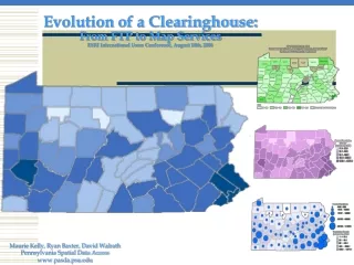
The data life cycle: preservation • Data is an asset that belongs to the citizens of Pennsylvania. • It is important that we not only provide access to data today but also that we manage it and preserve it so that it is available to future generations of Pennsylvanians. • Two issues that are highly significant are preservation of data and persistence of location. The Library of Congress and Federal Geographic Data Committee have been working on this issue for several years through a committee dedicated to identifying and reporting out on data preservation. • PASDA is a member of this committee and contributed to the recommendations and report. • PASDA is committed to long term preservation and access to historic data sets for Pennsylvania. • PASDA currently has a two level approach.
The data life cycle: Preservation • First, PASDA maintains an “historic” folder on the FTP site for each agency and dataset that is updated. • As new data comes in, the previous data is moved to the historic folder so it can still be accessed by users. • A link in the Data Summary pagedirects users to this folder. • Second, PASDA is addressing the long term archiving of data. • PASDA is working with the Penn State University Libraries and ICS-ACI on our long term archival processes(10, 20, 30+). • This approach combined with access to current data ensures that citizens of the Commonwealth have access to data today and in the future.
The data life cycle: persistence • Have you ever tried to access data or any information for that matter only to find it has disappeared? • PASDA is creating Digital Object Identifiers for all data on PASDA so that no matter where the actual data is, users will always be able to access all available formats, services, and applications related to a particular data set.
What are the gaps? • Many state agencies and local governments (and many organizations) that create authoritative data do not share their data openly. • Many do not have preservation processes in place to ensure that their data is available for the long term. • PASDA has proposed that even if, for example, a local government does not share its data openly or through PASDA, that we can create an archive of that data at no cost to the organization. This will ensure that their data is preserved in the future.
Questions part II: Preservation & archiving • We just have a few short questions for you about archiving data. Our hope is that we will get as many partners as possible to participate in a formal data archiving program through PASDA.
Pasda Today: Services • Data Storage • Data Management and Curation • Metadata Development • Metadata Training • Data Search and Retrieval • Data Download (in multiple formats) • Map Services/APIs/KMLs • Data Preservation and Archiving • Online Mapping Apps • Data Previewer • PA Imagery Navigator • PA Atlas • PA Mine Map Atlas • User Support • Offline Data Access • Integration with Additional Resources
Pasda website • The PASDA website itself is a search and retrieval service. Let’s take a look at the search and retrieval interface.
Questions part iii: PASDA Website search options • Now that we have reviewed the PASDA search options, please answer some questions about how we might improve it. • In addition, we are asking you about several potential enhancements to PASDA services including adding/improving the ability to interact with or add to data via services such as ArcGIS collector, the ability tovisualize and interact with data via various interfaces or ’widgets’ such as those available via Socrata or Insights for ArcGIS, integration of live streaming data.
Pennsylvania Atlas • The PA Atlas was created so users could easily visualize dozens of data sets available through PASDA without having to download each data set.
Pennsylvania Mine Map Atlas • The Pennsylvania Mine Map Atlas is an initiative of the Pennsylvania Department of Environmental Protection (DEP) and PASDA. • This application allows residents and stakeholders to see and download detailed underground mine maps that were once only available in hard copies. • It not only allows homeowners to view previously unavailable mine maps, but also allows them to see their home’s proximity to the nearest underground mine. • In addition, the PA Mine Map Atlas has been integrated into the Pennsylvania Historic Underground Mine Map Information System—PHUMMIS at the PA Department of Environmental Protection. • This database contains information relevant to past and present underground mining within the Commonwealth of Pennsylvania, including, but not limited to, maps, indices, locations of mines, and other pertinent data contained in various collections held or obtained by the Pennsylvania Department of Environmental Protection’s Office of Active and Abandoned Mine Operations.
Pennsylvania Imagery Navigator • The PA Imagery Navigator was created to provide easy access to the thousands of imagery, elevation, and LIDAR data sets available through PASDA. • It is consistently used between almost 5 to 6 million times per year.
Questions part iii: Imagery Navigator, LIDAR Tool, Penn PILOT • Since the PA Imagery Navigator is used so often, we want to be sure that it functions as well as possible for users. Therefore we have some questions focused specifically on improving this application. • In addition, we are looking for input on whether or not a specific LIDAR application would be useful and on how Penn Pilot might be improved.