Download
1 / 31
310 likes | 450 Views
GPS Activities at the Hydrographic Science Research Center, Department of Marine Science, The University of Southern Mississippi. By Sunil Bisnath and Dave Wells RTK Workshop 26-28 August 2002 Stennis Space Center. OUTLINE. Formation of the GPS research thrust GPS research activities

E N D
GPS Activities at theHydrographic Science Research Center,Department of Marine Science,The University of Southern Mississippi By Sunil Bisnath and Dave Wells RTK Workshop 26-28 August 2002 Stennis Space Center
OUTLINE • Formation of the GPS research thrust • GPS research activities • Current projects • 2001 NGLI buoy analysis • C-NAV receiver solution analysis • Future plans • Near-term support for NAVOCEANO • Long-term proposed projects
FORMATION OF THE GPS RESEARCH THRUST • Rationale: • Positioning and navigation, principally by GPS, a cornerstone of hydrographic activities • Purpose: • Designed to support positioning and navigation needs of NAVOCEANO • Personnel: • David Wells • Sunil Bisnath • Dave Dodd • Erik Quiroz
GPS RESEARCH ACTIVITIES • Testing and evaluation: • GPS receiver hardware and software • GPS processing software • Operational procedures and training: • Development of these items • Practical knowledge transfer • Forward-looking: • Technological developments • Technology-driven changes to procedures
2001 NGLI BUOY ANALYSIS • Experiment description: • Buoy equipped with an RTK GPS receiver and other sensors placed off the coast of Mississippi in summer of 2001 • Purpose: • Observe effectiveness of determining water levels from GPS on such a platform • Equipment and methodology: • ~ 10 km baseline • NovAtel OEM4 receivers • Other sensors used, including three accelerometers • NovAtel RTK solution recorded at buoy receiver • Analysis: • HSRC tasked with analysis of RTK solutions
RTK SOLUTION AVAILABILITY: 7 SEPT. 2001 Float Fixed
DISCUSSION: DATA AND SOLUTION GAPS • Solution availability statistics: • Mean = 81% • Std. dev. = 18 % • ~ 50 % of days have < 90 % availability • Probably causes: • Daily recording gaps due to CPU housekeeping • Buoy-related restrictions (e.g., power, GPS receiver, etc.) • Communications link-related restrictions • Available data: • Good satellite coverage and available RTK solutions for periods with GPS solutions
RTK HEIGHT SOLUTION RESULTS: 23 SEPT. 2001 Incorrect ambiguity Filter artifacts
RTK HEIGHT SOLUTION RESULTS: 23 SEPT. 2001 Incorrect ambiguity Filter artifacts
DISCUSSION: HEIGHT SOLUTION ARTIFACTSAND POSSIBLE CAUSES • Very short re-initialization period after data gaps • Appears to be a processing filter-based error being introduced in solution • Incorrectly determined ambiguities are apparent in solution (infrequent, but may last several tens of minutes)
ACCURACY ASSESSMENT OF MARINE (KINEMATIC) GPS DATA • Solution precision estimates from receiver are mostly likely internal precision values based on mathematical and stochastic models used • Precision estimates do not always represent the quality of the solution • Observed artifacts such as filtering effects and mis-identified ambiguities are not represented in precision estimates • How to determine the accuracy of marine (kinematic) GPS solutions in practice?
IMPROVEMENTS FOR 2002 EXPERIMENT • Increase solution availability rates by correcting for buoy system restrictions • Remove filter-based artifacts by altering processing inputs • Collocate buoy with tide gauges to allow for accuracy assessment of GPS-determined heights • Save all raw data for varied post-processing runs • Study alternative methods of providing precision estimates for RTK solutions
C-NAV SOLUTION ANALYSIS • C-NAV system: • Developed by C&C Technologies, Inc., based on C&C and NavCom hardware and NavCom and JPL software • Not a baseline-dependent RTK solution, but rather point position solution utilizing precise satellite ephemerides and clock offsets provided by real-time satellite link • Receiver algorithms still in the development stage • Analysis: • HSRC tasked with evaluating performance present generation of system
C-NAV RTG HEIGHT SOLUTION RESULTS:20-22 AUG. 2002 (All values in centimeters)
COLD-START C-NAV HEIGHT SOLUTION CONVERGENCE: 19,22,23 AUG. 2002 ~ solution convergence
POTENTIAL OF C-NAV USAGE • Great potential of system: • No baseline restrictions • No base station infrastructure requirements • Uniform global coverage • Desirable improvements: • Accuracy • Repeatability • Quantified system integrity • Shorten solution convergence period for practical use in situations where signal block is an issue
HSRC NEAR-TERM SUPPORT FOR NAVOCEANO • Continued NovAtel (RTK) evaluation • Continued C-NAV (precise point positioning) evaluation • 2002 buoy RTK solution evaluation and raw GPS data processing
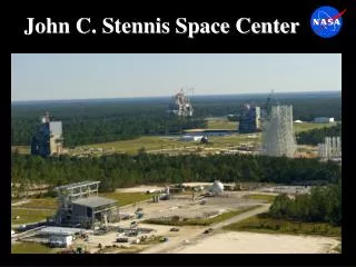
HSRC LONG-TERM PROPOSED RESEARCH • Establishment of high-precision, kinematic GPS test facility at Stennis • Study extension of RTK baselines, specifically effect of differential troposphere • Study alternative methods of providing precision estimates for RTK solutions • Investigate effects of GPS modernization and Galileo on hydrographic surveying results and therefore procedures • Investigate augmentation of GNSS technology with other sensors • Develop GPS training materials
ACKNOWLEDGEMENTS • NAVOCEANO for providing data, processing, and feedback on our analysis • PSI for providing technical information for the buoy data processing • C&C Technologies, Inc. for providing a C-NAV receiver and technical support • Department of Marine Science personnel for providing feedback on our analysis