Download
1 / 1
10 likes | 158 Views
Suspended Sediment Dynamics in Mountain Streams of Puerto Rico. Arica Crootof. Faculty Mentors: Ellen Wohl and Frederick Scatena. Research Experiences For Undergraduates - Program in Water Research at Colorado State University - Summer 2006. Puerto Rico Fourth largest Caribbean island

E N D
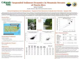
Suspended Sediment Dynamics in Mountain Streams of Puerto Rico Arica Crootof Faculty Mentors: Ellen Wohl and Frederick Scatena Research Experiences For Undergraduates - Program in Water Research at Colorado State University - Summer 2006 • Puerto Rico • Fourth largest Caribbean island • Subtropical maritime climate • Receives ~1,600mm of precipitation each year • Discharges 2.7-9.0 million metric tonnes of suspended sediment each year Suspended Sediment Rating Curves For the Nine Study Streams Quebrada Sonadora (within LEF) Rio Mameyes at Rt. 3 (outside LEF) Study Sites Outside the LEF Total Suspended Solids (mg/L) Luquillo Experimental Forest Results Discharge in mm of runoff/day Rating curves have been used to relate suspended sediment concentrations as a function of discharge. This study developed suspended sediment rating curves by combining data from the United States Geological Survey and Long-term Ecological Research databases for the following nine rivers in eastern Puerto Rico: Quebrada 1, Quebrada 2, Quebrada 3, Quebrada Sonadora, Quebrada Guaba, Rio Icacos, Rio Mameyes (Puente Roto), Rio Mameyes at Rt. 3 and Rio Fajardo. Using a 95-percent confidence interval discharge accounted for 22.5, 13.6, 25.7, 34.9, 41.2, 53.9, 30.5, 31.7, and 62.6 percent of the suspended sediment concentration variation respectively. When comparing rivers outside of the Luquillo Experimental Forest, the Rio Mameyes at Rt. 3 and Rio Fajardo, to the other seven rivers located within the Luquillo Experimental Forest, there was no significant difference in the concentration of suspended sediment per unit of discharge. Therefore, according to the results of this study the land use practices within the drainage basins of the Rio Mameyes at Rt. 3 and the Rio Fajardo do not significantly increase the concentration of suspended sediment per unit of discharge. Suspended Sediment Rating Curve for Mameyes at Rt. 3 Suspended Sediment Rating Curve for Quebrada Sonadora Site Characteristics www.experience-puertorico.com/ map/isla(new).html • Suspended Sediment • Natural vs. Development • Suspended Sediment as a pollutant • Ecological and Economic costs • Total Suspended Sediment (TSS) vs. Suspended Sediment Concentration (SSC) • Biocomplexity Project • Rivers and Roads • Objectives • Develop suspended sediment rating curves for the following nine streams: Quebrada 1, Quebrada 2, Quebrada 3, Quebrada Sonadora, Quebrada Guaba, Rio Icacos, Rio Mameyes (Puente Roto), Rio Mameyes at Rt. 3 and Rio Fajardo. • Compare SS rating curves for rivers within the Luquillo Experimental Forest (LEF) to those outside of the LEF. • Hypotheses • TSS will be positively correlated to a river’s discharge and will best be described by a power function. • Rivers outside of the LEF, Rio Mameyes at Rt. 3 and Rio Fajardo, will have greater concentrations of TSS per unit of discharge compared to the other seven sites within the LEF. Total Suspended Solids (mg/L) Total Suspended Solids (mg/L) Discharge (mm of runoff/day) Discharge (mm of runoff/day) • Conclusions • For the nine study streams total suspended solids can be expressed as a power function of discharge. • Using a 95-percent confidence interval discharge accounts for 22.5, 13.6, 25.7, 34.9, 41.2, 53.9, 30.5, 31.7, and 62.6 percent of the TSS variation for the following rivers: Quebrada 1, Quebrada 2, Quebrada 3, Quebrada Sonadora, Quebrada Guaba, Rio Icacos, Rio Mameyes (Puente Roto), Rio Mameyes at Rt. 3 and Rio Fajardo respectively. • Rio Mameyes at Rt. 3 and Rio Fajardo, both sites outside of the Luquillo Experimental Forest, did not have significantly higher concentrations of suspended sediment per unit of discharge when compared to the other seven rivers located within the Luquillo Experimental Forest. Acknowledgements The author expresses her gratitude to Dr. Fredrick Scatena and Dr. Ellen Wohl for their guidance and support throughout the REU program. In addition, this project could not have been conducted without the wealth of data that individuals have collected for the USGS and LTER databases. Funding for the REU Program in Water Research at CSU was provided by a grant from the The DoD's ASSURE (Awards to Stimulate and Support Undergraduate Research Experiences) Program in partnership with the National Science Foundation.