HURRICANE EARL SUMMARY
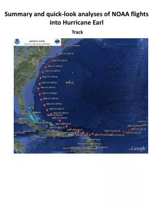
HURRICANE EARL SUMMARY. UPDATED SEPTEMBER 3, 2010 2:00 AM. Hurricane Earl – 12:45 AM. HURRICANE EARL PROJECTION. Earl will likely pass 50 to 100 miles southeast of Nantucket around midnight Friday night Probably as a weakening Category 2 hurricane Increased confidence in track and intensity

HURRICANE EARL SUMMARY
E N D
Presentation Transcript
HURRICANE EARL SUMMARY UPDATED SEPTEMBER 3, 2010 2:00 AM
HURRICANE EARL PROJECTION • Earl will likely pass 50 to 100 miles southeast of Nantucket around midnight Friday night • Probably as a weakening Category 2 hurricane • Increased confidence in track and intensity • Preparations for Earl should be complete by around noon Friday for south coast, Cape Cod, and islands • Primary area of concern continues to be Cape Cod, Nantucket and Martha’s Vineyard
HURRICANE EARLWATCHES/WARNINGS • Hurricane Warning: • Westport to Hull • But primary concern is with Cape Cod, Martha’s Vineyard, and Nantucket • Tropical Storm Warning • New Haven, CT to Westport, MA • Southeast Connecticut and Rhode Island coast including Block Island • Hull, MA to Merrimack River
SOUTHERN NEW ENGLAND IMPACTSMarine • High seas, high surf, and dangerous rip currents through Saturday • Along most ocean exposed beaches whether south or east facing • High surf and dangerous rip currents may be the greatest risk to life • Seas over open coastal waters • 10 to 20 feet to left of track • 20 to 30+ feet very near track • 30 to 40+ feet to right of the track
HURRICANE EARL IMPACTSWind • Be prepared for: • Tropical Storm force winds with Hurricane force gusts Nantucket, Cape Cod and Martha’s Vineyard – with best chance for any sustained hurricane force winds across the outer Cape and Nantucket • Tropical Storm Force winds with only an outside chance of hurricane force gusts Buzzards Bay coast and Plymouth County coast • Tropical Storm Force winds (either sustained or in gusts) likely along the immediate Rhode Island coast and Block Island • Tropical Storm Force wind gusts likely along Massachusetts east coast and interior southeast Massachusetts • Any further shift to the west of the track would shift stronger winds to W and NW
HURRICANE EARL IMPACTSWind Timeline • Arrival of Tropical Storm force winds • Mid to late afternoon (3 to 5 pm EDT) • Peak of storm • First part of tonight (8 pm to 2 am EDT) • Departure of Tropical Storm force winds • Late tonight (4 am to 8 am EDT) • However, W/NW winds gust to 30 knots Saturday
HURRICANE EARL IMPACTSHeavy Rain/Flooding • 2-4 inches of rain with locally up to 6 inches Cape Cod, Martha’s Vineyard, Nantucket, as well as southern Bristol and southern Plymouth Counties in southeast Massachusetts • Flash Flood Watch in effect for these areas • Heaviest rain 8 pm to midnight • 1-3 inches for Rhode Island and rest of eastern Massachusetts • Urban poor drainage flooding most likely problem • 1 inch or less near CT river valley
HURRICANE EARL IMPACTSStorm Surge Flooding • Storm surge of 2 to 4 feet may cause minor flooding along vulnerable portions of the Nantucket, Chatham and Martha’s Vineyard shoreline during the Friday evening high tide • Surge of around 2 feet may cause spotty minor coastal flooding Narragansett Bay. • In worst case scenario Fox Point Barrier water level could approach 6.5 to 7 feet MLLW for Friday afternoon high tide – but not all that likely • Splash over around the time of the Friday late afternoon high tide ocean exposed south coast due to large breakers • Up to 2 feet of surge possible rest of Massachusetts east coast during Friday evening high tide with splash over possible • Minor storm surge flooding possible for Wellfleet and Provincetown harbors after Earl passes Friday night • 3 to 6 foot surge possible 2 to 4 AM but between high tides
POST HURRICANE EARL • Mostly Sunny and gusty Saturday • NW wind gusts 30 to 35 mph • Swells, surf, and rip currents subsiding during Saturday but still dangerous • No hazardous weather rest of Labor Day Weekend