Application of Multitemporal Differential Interferometry for Peri-Urban Landslide Investigations
This study explores the effectiveness of multitemporal differential interferometry (DInSAR) in analyzing landslides in peri-urban areas. Conducted by researchers from Italy, the work investigates landslide dynamics using ERS images and combines observational data with advanced remote sensing techniques. Supported by the European Community and the Italian Space Agency, the findings aim to enhance our understanding of landslide behavior and improve risk management strategies in urban-adjacent regions.

Application of Multitemporal Differential Interferometry for Peri-Urban Landslide Investigations
E N D
Presentation Transcript
Test of applicability of multitemporal differential interferometry analysis to landslide investigations in peri-urban areas* Wasowski J.[1], Bovenga F.[2], Nutricato R. [2],Refice A. [3], and Casarano D. [1] [1]CNR-IRPI-Bari, c/o Politecnico di Bari, Italy; wasowski@area.ba.cnr.it [2]Dipartimento Interateneo di Fisica, Bari, Italy [3]CNR-ISSIA, Bari, Italy * Work supported in part by the European Community project LEWIS and by the Italian Space Agency (ASI) grant I/R/073/01; ERS images provided by ESA under ENVISAT project AO-313
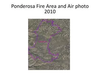
CaramanicoTest Area (Italy) – ERS SLC Amplitude Caramanico Town Air Photo