Download
1 / 44
440 likes | 572 Views
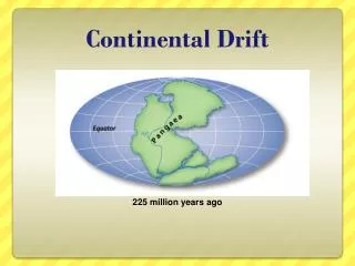
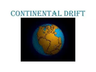
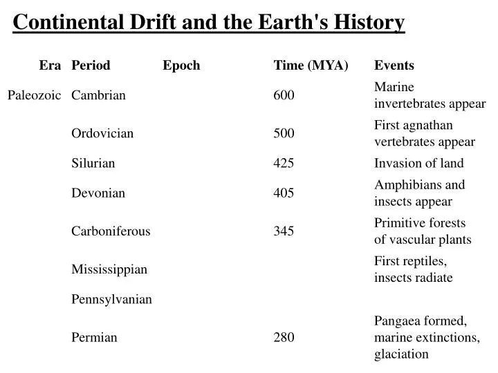
Continental Drift and the Earth's History. The time period we're most interested in begins about 230 MYA, at the end of the Paleozoic Era, and thus at the end of its last period, the Permian.

E N D
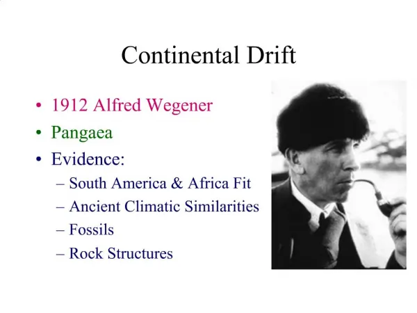
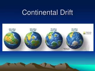
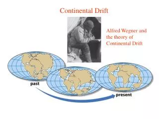
The time period we're most interested in begins about 230 MYA, at the end of the Paleozoic Era, and thus at the end of its last period, the Permian. This begins our history at the time when the continental land masses were last united into a single great mass called Pangaea, which was centered in the southern hemisphere. The distributions of contemporary species have been far more influenced by events since the break-up of Pangaea than anything which occurred before its formation.
From a biogeographic point of view, it is apparent that long before the formation of Pangaea there had been a wide variety of vascular plants, amphibians, insects, lizards, and later, while Pangaea was united, angiosperms, birds, and mammals. All these species could wander over most or all of the terrestrial continental areas freely. Most of the large scale barriers to movement of species arising since are directly or indirectly traceable to effects of drift. Adding to continental drift, there are 3 kinds of barriers important in restricting large scale distributions of groups of organisms.
They are: • rapid, extreme changes in climate, • oceans or other large bodies of water and • mountain ranges. • The latter two are basically the result of dynamic geological processes which are collectively called plate tectonics, and which are the underlying cause of continental drift. • Biogeographers separate the land masses of earth into 8 “realms”, with those latter two types of barriers isolating realms from each other. The realms are:
the Nearctic - North America and Greenland. • the Palearctic - Europe and Asia, but excluding the • Indian subcontinent and southeast Asia. • the Neotropical - South America + Central America • and southernmost Mexico. • the Ethiopian - Africa south of the Mediterranean • coastal region. • the Oriental - India and southeast Asia. The • Himalayas rise between the Oriental and Palearctic. • the Australasian - Australia, New Guinea, New • Zealand, and the Pacific islands southeast of • Wallace's line. • 7) the Antarctic • 8) Oceania - Pacific Islands
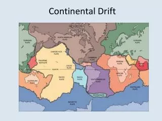
Tectonic plates and biogeographic realms correspond closely, but not perfectly.
The explanation for separation of realms and many species distributions arises from continental drift. However, from a strictly North American perspective other factors dominate… The key factors in the northern hemisphere are: 1) the rising of the Rocky Mountains, separating the east and middle of North America from the west, 2) the effects of Pleistocene cycles of glaciation on both the physical environment and species' distributions, and 3) the repeated presence of an extensive land bridge connecting North America and Asia at the Bering Strait.
The evidence supporting the importance of continental drift to biogeographic pattern is: 1. The fit between South America and Africa using contemporary coastlines. In the region of close fit the cratons match, not only in shape, but also stratigraphy. There is a near absolute correspondence in the stratigraphy of the cratons along the east coast of the ‘prominence’ of South America and the 'armpit' of west Africa. Antonio Snider-Pelligrini (1858) described the geometric fit, but the stratigraphic fit was described only as late as 1968 (Hurley 1968; Rand 1969).
The cratons include not only emergent ‘land’, but the continental shelves as well. These cratons are Pre-Cambrian shield (2-3 billion years old). The match between fragments in Brazil (and to a lesser extent Argentina) and West Africa (Sierra Leone, Liberia, the Gold Coast, Ivory Coast, Nigeria, Zaire) is so close as to strongly suggest these continents were once fused. The match is not only structural (i.e. the thickness and order of individual layers), but also chemical. Similarly, the sedimentary rock of Brazilian coast and Gabon match extremely well, also suggesting earlier fusion.
Close match throughout these areas Andes rise as South America moves westward into the Pacific plate
2. The Evidence of Permian Flora A map of areas in the southern continents apparently glaciated during the Permian shows that a logical physical alignment also matches the distributions of flora across continents.
During the period from 280-230 MYA there is strong evidence of widespread glaciation over parts of South America, Africa, Antarctica, Australia, India and the Falkland Islands. These glaciers existed from the late Carboniferous, and probably had considerable influence over the southern flora. That flora, different from the species composition on northern continents, was dominated by seed-bearing tree ferns of the genera Glossopteris and Gangamopteris. The distribution of that flora is shown on the map.
The flora (deciduous) is considered indicative of cool temperate conditions, and is evidence that India and Antarctica were both once temperate, though today their climates represent opposite ends of the spectrum. The flora dominated the edges of the ice sheets and expanded during interglacials. The northern limit of the flora was seemingly set by warmer climates. We call that united, supercontinental mass Gondwanaland. The name is derived from a site in India, which was one of the key places used to identify the Glossopteris flora.
3. The Evidence of the Fossil Record The zoological fossil record distinguishes northern from southern continents, and indicates the northern continents were fused into a supercontinent we call Laurasia (its name derived from a site in the Laurentian Mountains which characterized the fauna). The important (negative) evidence is the fossil record of a sheep-sized dinosaur, Lystrosaurus. It was present during the earlier part of the Triassic in Antarctica and at the same time in southern Africa and India, but has not been found in North America or Europe.
Following (in time, and thus just above in stratigraphy) the Lystrosaurus community was a widespread assemblage described by the presence of Cynognathus, present on most southern continents, but not Antarctica or Australia. Why? It is evidence timing the rift of continents forming Gondwanaland. These faunas, however, create one of the great puzzles of biogeography. Members of both these faunas (Lystrosaurus and Cynognathus) have been found at the same time in the fossil record in southern China (Sinkiang and Shansi provinces.
While these kinds of evidence point to the existence of Pangaea and its rift into Gondwanaland and Laurasia, the objective is to reconstruct continental histories. How do we achieve that? Methods of Reconstructing Continental History The continents are not made up of what is, in geological terms, heavy dense material. The rigid, outer shell of the earth (or lithosphere) is made up of a number (between 6 and 10) of separate plates of material less dense than either deeper layers (the asthenosphere) or the core materials. These plates therefore float upon the asthenosphere.
The movements of the plates are somewhat like bumper cars at an amusement park; they converge, collide, rotate, slide past one another, and occasionally one rides up over another after collision. The plates generally consist of 2 layers. The denser and deeper layer is the rock which forms the ocean floor (and the only layer on non-continental plates) and the underlayer beneath continents. The material of this layer is called sima after its chief ingredients, silicon and magnesium. Geologically, this rock is mostly basalt.
The emergent continents are made up of lighter silicaceous materials called sial after its main ingredients, silica and aluminum. The Canadian Shield is a prime example of the sial crust. • Movements are traceable only because of the geological processes involved: the formation and disappearance of parts of whole plates, i.e. plate tectonics. The evidence of movement and position comes from 2 major sources: • Paleomagnetism • Sea Floor Spreading
Here’s the plate map again. Now note the directions of movement indicated by the arrows, e.g. the continuing separation of the South American plate from the African.
Paleomagnetism Paleomagnetism can determine the latitudes (but not the longitudes) of continents through their history. Paleomagnetism refers to the weak magnetic orientations of magnetic materials, elemental compasses oriented towards the earth's magnetic poles, fixed into rocks at the time of their formation. The magnetic elements are iron, cobalt and nickel (and titanium oxides). By aging rocks using isotopic methods (carbon-14, potassium-argon, etc.) the history of latitudes of a continental mass can be obtained.
Assume the stratigraphy of our exemplar continent includes only 3 layers beneath the present surface, and that these layers have been aged as respectively 50, 100, and 150 million years old.
What orientation does a 'compass' take? It points toward the poles. Thus, if our continent were to be observed 150 MYA, there would be only one layer on the continent, with a compass orientation to the poles. If the continent were in the far south, say 60o latitude, the paleomagnetic orientation of iron-bearing rocks would be at an angle of 60o to the rock (or layer) surface. The angle of magnetic orientation with respect to the surface of the layer would be equal to the latitude at the time of rock formation. 100 MYBP the continent was at the equator, and the orientation of the compass is 0o to the surface…
Paleomagnetism can also provide information about twisting (rotation) of the continental masses at any latitude (if the 'compasses' for each layer don't point N-S, with different layers oriented at different angles with respect to the surface, then the mass has rotated, as well as drifted, during its movements). The weakness of the method is the assumption that the poles have remained fixed in place (or it must correct for polar “wandering”). Polar wandering is small compared to latitudinal movements of the continents. This map giving Gondwanaland distributions shows polar wandering…
If you’re into plate tectonics, you also know that the magnetic poles have repeatedly reversed. More about that later.
The previous ‘map’ shows the gradual wandering of the poles. However, it appears there have also been times when the poles (and the axis of rotation) of the earth shifted rapidly, and quite a bit. One such shift was around 84 MYBP. This shift is believed due to shifting of mass in the mantle, far from the axis of rotation, and therefore having large effect.
Longitude and Sea Floor Spreading The basic model: Asterisks along the portion of the plate at the point of contact and submergence indicate the regions of earthquake activity (the Benioff zone).
To understand how longitude can be determined we need to step back into geology for a moment. The molten core of the earth is undergoing what is described as sluggish thermal convection. Imagine water heating in a pan. If you look into the pan as the water heats, but before it boils, you see a number of relatively separate convection cells. Sluggish means that these currents in the earth’s core move only a few cm per year. Plates of the lithosphere ride these currents like surfboards on the ocean.
These currents, like atmospheric circulation cells, must rise and fall, as well as move laterally. There are distinct zones where this rise and fall is evident. At mid-ocean, particularly in the Atlantic, ridges form a nearly continuous path. They are zones of new sea floor formation. There are other regions with deep trenches; the trenches are the deepest regions of the ocean. They are zones where convection returns sea floor into the magma. When one plate is forced down under another, called subduction, sea floor also descends and melts back into the magma.
The average thermal flow over the ocean floor is about 1 x 10⁻⁸ calories /cm2/sec. At the ridges the rate of heat flow is 2-8x this rate, at the trenches heat flow is reduced from this average by about the same amount (1/10 the average). Faulting along the ridges indicates that this is a 'pull-apart' zone. The mantle is ripped by being pulled apart, riding on separate convection currents on the two sides of the ridge. The rift opened by this pull- apart is filled by rising magma (the new sea floor). The formation of new ocean floor occurs continuously at mid-ocean ridges at a rate of a few centimeters a year.
Rate of formation is verified by ageing lava rock on volcanic islands (or samples of sea floor), which should be of differing ages because they are at different distances from the ridge. Ascension and other south Atlantic islands lie along an arc perpendicular to the south Atlantic ridge. The arc reflects the existence of a 'hot spot', a local weakness that leads to particularly strong upwelling alongside the ridge, and the formation of volcanic islands above the weakness. The islands are about 50 million years old/1000 km from the ridge. A similar situation has produced the Hawaiian arc…
The convective flow is not terribly even. The ages of sea floor elsewhere along the south Atlantic ridge line do not follow the same age regression, i.e. 50 x 106 years old/100 km. Rates also differ when we look across different ridges (and at different times)…
Continents riding on the plates are 'twisted' (rotated) with respect to each other when the rate of sea floor formation differs near them, or even along their extension ‘parallel’ to the ridge. The most recent islands along the south Atlantic and Hawaiian arcs (and others around the world) are frequently actively volcanic (another indication of active upward flow from beneath the island), while older islands, carried along with the sea floor away from the zone of upward flow at the ridge or weakness, are older, inactive volcanically, and, among the very oldest, may have 'subsided' to become sub-surface seamounts or guyots.
Island arcs are path maps for the continents that lie at their ends. Such continents were once together (e.g. South America and Africa), but are now separated by sea floor spreading which has occurred between them. Along the south Atlantic arc, Tristan de Cunha lies just to the east of the mid-Atlantic ridge is less than 1 million years old and still has active volcanoes. From it to Angola extends the lateral Walvis ridge, and to southern Brazil the Rio Grande ridge. The places where these lateral ridges reach their respective continents are a perfect geographic fit when the continents are united.
A break – this is Tristan de Cunha, a photogenic view of its main active volcano.
In the absence of island arcs the positions of continents historically can still be reconstructed. Sea floor spreading is the basic geological process used, but additional data is obtained from 'anomalous' reversals in the magnetic polarity of the earth. Reversal has happened many times - 171 times in the last 76 million years. Reversals in polarity are recorded on the sea floor as stripes of alternating magnetic polarity running parallel to mid-oceanic ridges; the magnetic orientation frozen into the rock of the sea floor. Look at the banding in the north Pacific and the south Atlantic in the earlier diagram…
Bands in the two areas are in the same order and basically proportional. The rates of spread are much different, however. Sea floor spreading is more rapid in the Atlantic. Also, rates are not constant over time. Along the margins of plates being moved at different rates by their underlying convection cells they must somehow slide past one another. There is enormous friction between the plates, and the 'slippage' is a major source of what are termed ‘strike-slip’ earthquakes.
Finally, one plate can ride up on another and force it downwards. The plate on which North America rides and the Pacific plate collide at the western boundary of the continent. The Pacific plate is being forced down, and as the sea floor slides down into the trenches which rim the Pacific, the sliding friction generates both heat (which results in volcanic activity like the relatively recent eruption of Mt. St. Helens in Washington) and earthquakes (since the sliding process is not even. Collision and friction can also cause orogenesis, the rising of mountain ranges (Himalayas and Urals are examples of purely plate-driven orogenesis).
References Brown, J.H. and A.C. Gibson. 1983. Biogeography. Mosby, N.Y., N.Y. Chapter 5. Eliot, D.H. et al. 1970. Triassic tetrapods from Antarctica: evidence for continental drift. Science 169:1197-1201. Hurley, P.M. 1968. The confirmation of continental drift. Scientific American 218:52-62 Rand, J.R. 1969. Pre-drift continental nuclei. Science 164:1229-1242 Schopf, J.M. 1970. Relation of the floras of the Southern Hemisphere to continental drift. Taxon 19:657-74.