Download
1 / 7
70 likes | 88 Views
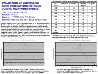
Explore quantitative precipitation forecasting, convective initiation, and boundary layer processes during IHOP 2002. Analyze wind data collected from various instruments for statistical comparisons and develop hybrid data products combining surface measurements with lidar data.

E N D
HARGLO-3: Wind Intercomparisons During IHOP Geary Schwemmer, Bruce Gentry NASA/GSFC Tom Wilkerson USU
International H2O Project (IHOP 2002) • Research Objectives: • Quantitative Precipitation Forecast • Convective Initiation • Boundary layer processes • Instrumentation • 7 May to 16 June 2002 • Southern Great Plains
IHOP Homestead Site Wind Instruments • GLOW Collected over 210hrs of data. • HARLIE operated 24/7 • SKYCAM cloud-tracked winds • S-POL Doppler Radar • surface anemometer, GPS sondes (1-4 /day) • Sodar, MAPR, Umass FM-CW Radar • Transients: MIPS, DOW, X-POL, ELDORA, HRDL, WCR, Dropsondes
HARGLO-3 Objectives • Statistical Comparisons of various wind measurements • Develop hybrid data products combining surface data with aerosol and molecular lidar data • Determine validity “windows” in time and space for various instruments
Time-line of Homestead Wind Measurements: 43 days, 16 wind instruments
HARLIE IHOP Data Products Wind Profiles Backscatter Profiles Boundary Layer Heights Cloud Fraction vs Height & Time
HARGLO – 4+ • Increase & extend ground-based instruments • Focus on relating airborne to ground-based measurements and verifying sampling strategies • Help develop a validation plan for spaceborne Doppler wind lidars