Download

1 / 18
180 likes | 195 Views
Applying ISO/TC 211 standards to the development of standards through Geospatial One-Stop. Presented at ISO TC 211 Standards in Action workshop by Julie Binder Maitra, USA DIN, Berlin, Germany 2003-10-29.

E N D
Applying ISO/TC 211 standards to the development of standards through Geospatial One-Stop Presented at ISO TC 211 Standards in Action workshop by Julie Binder Maitra, USA DIN, Berlin, Germany 2003-10-29
Applying ISO/TC 211 standards to the development of standards through Geospatial One-Stop Topics • Overview of Geospatial One-Stop (slides 3-5) • Standards under development through Geospatial One-Stop (slides 6-7) • Standardization approach (slides 8-9) • Applying ISO/TC 211 standards to the development of standards through Geospatial One-Stop (Slides 10-15) • Status of Geospatial One-Stop (Slide 16) • Links (Slide 17)
Geospatial One-Stop E-Government (E-gov) Initiative • Component of President’s Management Agenda • Geospatial One-Stop is one of 24 E-gov initiatives Objectives • Raise the visibility of the strategic value of geographic information and the National Spatial Data Infrastructure (NSDI). • Accelerate implementation of the NSDI. • Increase Federal agency accountability for the stewardship and sharing of geospatial resources. • Make it easier, faster, and less expensive for all levels of government and public to access geospatial information.
Geospatial One-Stop • U.S. Office of Management and Budget oversees the direction of all E-Government Initiatives. • U.S. Department of the Interior serves as the Managing Partner for Geospatial One-Stop. • A Board of Directors of both Federal and non-Federal representatives provides guidance to the project. • The Federal Geographic Data Committee (FGDC) provides project support to the implementation of Geospatial One Stop.
Geospatial One-StopProject Modules • Develop standards for data themes used by many different GIS applications. These themes are known as NSDI Framework themes. • Inventory existing Framework data holdings and create metadata to enable data discovery through the NSDI Clearinghouse. • Create metadata for planned data acquisition and update of Framework data to enable data discovery through the NSDI Clearinghouse. The intent is to enable opportunities for partnerships. • Prototype and deploy enhanced data access and web mapping services for Federal Framework data. • Establish a (One-Stop) Federal Portal providing web services to extend the capabilities of the NSDI Clearinghouse Network.
Standards under Development through Geospatial One-Stop Rail Air Roads Elevation Transportation Transit Base Standard Waterways Cadastral Geodetic Control Governmental Units Orthoimagery Hydrography
Standards under Development through Geospatial One-Stop Modules 1, 2, 3, 4, 5 Final draft pre-ANSI harmonized framework data standard Module 1 Working draft base standard Base Standard Elevation Cadastral Hydrography Draft framework data standard (submitted September 30) Working draft data theme standards Governmental Units Orthoimagery Geodetic Control Transportation Working draft sub-theme standards Air Rail Roads Transit Waterways
Standardization approach • Bring together subject matter experts from all levels of government, academia, and the private sector to develop data standards for NSDI Framework themes • Develop standards through the procedures of the InterNational Committee for Information Technology Standards (INCITS).
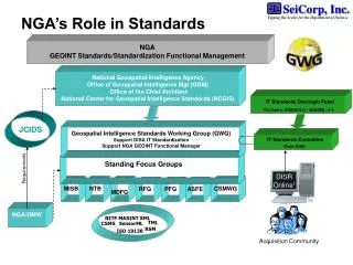
Is U.S. member body of ISO Is a Technical Committee of ISO Technical Committee (TC) 211 Is liaison with Accredits U.S. TAG to MOU Chairs American National Standards Institute (ANSI) ICSP NIST Reports to Is accredited by InterNational Committee on Information Technology Standards (INCITS) OMB Sets Policy For Participate in standards development Is a Subcommittee of Consortia and Academia Is a voting member of Is an advisory member of States FGDC INCITS Technical Open GIS Consortium CommitteeL1 OMG W3C OASIS etc. Municipalities Is strategic member of Other Standards Development Organizations Federal Standards ANSI Accredited Standards Development Organization Geographic Information Standards Activities in the United States Standards organizations
Applying ISO/TC 211 Standards to the Development of Standards through Geospatial One-Stop Focus on • ISO 19109, Geographic information - Rules for application schema • ISO 19115, Geographic information - Metadata • ISO 19123, Geographic information - Schema for coverage geometry and functions
Applying ISO/TC 211 Standards to the Development of Standards through Geospatial One-Stop Application of ISO 19109 • Use General Feature Model to describe geographic features (applies to geodetic control, cadastral, hydrography, transportation, and government units boundaries themes) • Build Application schema in UML using rules in Section 8
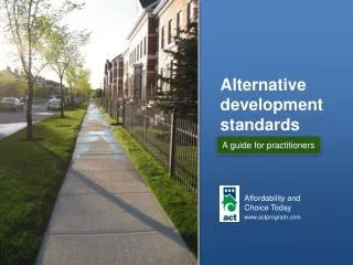
Applying ISO/TC 211 Standards to the Development of Standards through Geospatial One-Stop UML Example: Government Units Boundaries
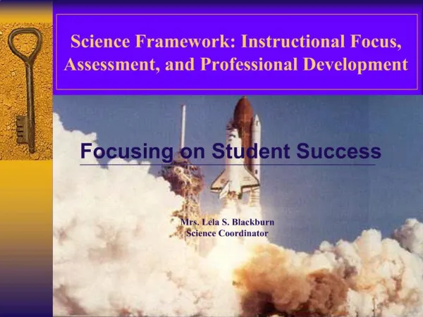
Applying ISO/TC 211 Standards to the Development of Standards through Geospatial One-Stop Data dictionaries provide supporting documentation for UML models Example: excerpt from data dictionary for GUB_GovernmentalUnit class
Applying ISO/TC 211 Standards to the Development of Standards through Geospatial One-Stop • Application of ISO 19115 • Standards developed through Geospatial One-Stop will be compliant with ISO 19115 • Some elements listed as optional in ISO 19115 are mandatory in Geospatial One-Stop • examples: Metadata standard name, Metadata standard version, Dataset purpose, Dataset progress, Dataset maintenance and update frequency • Elements cross-walked to FGDC Content Standard for Digital Geospatial Metadata, FGDC-STD-001-1998 (version 2.0); therefore, data standards will be compliant with FGDC standard
Applying ISO/TC 211 Standards to the Development of Standards through Geospatial One-Stop • Application of ISO 19123 (for digital orthoimagery and elevation themes) • Digital orthoimagery adopts ISO 19123 classes such as CV_Coverage, CV_ContinuousGridCoverage, CV_Grid, CV_GridValuesMatrix • Elevation standard currently undergoing revision, which will instigate revision of orthoimagery.
Status of standards being developed through Geospatial One-Stop • Standards project registered as INCITS Project 1574-D, Geographic Information – Framework Data Content Standard • Package of standards was submitted for review and ballot by INCITS Technical Committee L1, Geographic Information Systems, on 8 October 2003 - comparable to submitting an ISO standard for ballot as CD • Objective is an American National Standard (ANS)
Resources • Geospatial One-Stop, www.geo-one-stop.gov • FGDC, www.fgdc.gov • INCITS Technical Committee L1, www.incits-l1.org • INCITS, www.incits.org
Questions? Julie Binder Maitra FGDC Standards Coordinator Vice-chair, INCITS L1 Reston, Virginia USA jmaitra@usgs.gov (703) 648-4627