Download

1 / 3
30 likes | 51 Views
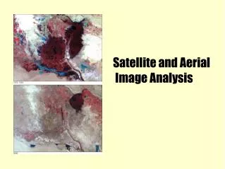
Different types of equipment or devices are used for aerial photography including fixed-wing aircraft, multi-rotor unmanned aircraft systems (UAS), helicopters, balloons, parachutes, blimps and dirigibles, rockets, kites, vehicle-mounted poles, and stand-alone telescoping. Aerial photography offers cost-effective and high-precision solutions for volume calculations, planning purposes, route design or renovation of existing mapping. Advancements in technology related to UAV and drone has increased the popularity of location-based services worldwide.<br>Increasing use of aerial imagery in number of sectors is the major driver for the market growth. Aerial imaging has been used in disaster risk operation, archeology, cartography, journalism, defense and security, construction and development, tourism, and intelligence surveillance and reconnaissance (ISR). Furthermore, aerial imaging offers a variety of ground-based applications.<br>Get PDF copy @ https://www.coherentmarketinsights.com/insight/request-pdf/3523 <br> <br><br><br>Key players operating in the global aerial imaging market are Google, Inc., Kucera International, Inc., NRC Group ASA, GeoVantage, Inc., Fugro N.V., Landiscor Real Estate Mapping, Digital Aerial Solutions, LLC, Cooper Aerial Surveys Co., Nearmap Ltd, and EagleView Technologies, Inc.<br><br><br><br>Market Trends:<br>Personal aerial mapping system (PAMS)<br>Personal aerial mapping system is a package of hardware and software, which enables an operator to perform aerial mapping and make survey of small areas. It processes superior 3-D surface height models and true orthophotos, or an overview map in the field. PAMS can be operated by a single user since it offers quick and easy functionality, unlike conventional methods. This eventually saves money and time. <br><br>Aerial archeology and 360-degree panoramas<br>The aerial imagery of archeological sites has improved significantly, enabling thorough study of ancient landscapes and historical sites. During the aerial archeological survey, a vertical or oblique aerial image is capture to better understand the landscape. For instance, aerial imaging has been used to find Iron Age and Roman sites in Britain, Mayan ruins in Belize and Nazca lines in Peru. <br><br>Market Opportunities<br>1.tGrowing demand for aerial imaging from archeology sector is expected to present lucrative growth opportunities<br>The demand for aerial imaging has increased significantly in the recent past from the archeology sector. Aerial imaging offers enhanced insight for understanding archeological landscapes, as it reveals some of the features which are too large, too discontinuous or too faint to be identified at ground level. This situation is typical in case of earthworks, crop marks, soil marks or parch marks.<br>2.tIncreasing demand from the real estate industry is expected to provide major business opportunities<br>Aerial imaging is being increasingly implemented in real estate and construction industry for better overview of a property and the surrounding area. Standalone images of a property have become outdated in the recent past since drones and UAVs deliver better results.<br><br>Any Query? Talk To our Analyst @ https://www.coherentmarketinsights.com/insight/talk-to-analyst/3523 <br><br>About Coherent Market Insights:<br>Coherent Market Insights is a prominent market research and consulting firm offering action-ready syndicated research reports, custom market analysis, consulting services, and competitive analysis through various recommendations related to emerging market trends, technologies, and potential absolute dollar opportunity.<br><br>Contact Us:<br>Name: Mr. Raj Shah<br>Phone: US 12067016702 / UK 4402081334027<br>Email: sales@coherentmarketinsights.com <br>Visit Our Blogs: https://blog.coherentmarketinsights.com <br>

E N D
AERIAL IMAGING MARKET| GROWTH & INNOVATIONS Different types of equipment or devices are used for aerial photography including fixed-wing aircraft, multi-rotor unmanned aircraft systems (UAS), helicopters, balloons, parachutes, blimps and dirigibles, rockets, kites, vehicle-mounted poles, and stand-alone telescoping. Aerial photography offers cost- effective and high-precision solutions for volume calculations, planning purposes, route design or renovation of existing mapping. Advancements in technology related to UAV and drone has increased the popularity of location-based services worldwide. Increasing use of aerial imagery in number of sectors is the major driver for the market growth. Aerial imaging has been used in disaster risk operation, archeology, cartography, journalism, defense and security, construction and development, tourism, and intelligence surveillance and reconnaissance (ISR). Furthermore, aerial imaging offers a variety of ground-based applications. Get PDF copy @ https://www.coherentmarketinsights.com/insight/request-pdf/3523 Key players operating in the global aerial imaging market are Google, Inc., Kucera International, Inc., NRC Group ASA, GeoVantage, Inc., Fugro N.V., Landiscor Real Estate Mapping, Digital Aerial Solutions, LLC, Cooper Aerial Surveys Co., Nearmap Ltd, and EagleView Technologies, Inc.
Market Trends: Personal aerial mapping system (PAMS) Personal aerial mapping system is a package of hardware and software, which enables an operator to perform aerial mapping and make survey of small areas. It processes superior 3-D surface height models and true orthophotos, or an overview map in the field. PAMS can be operated by a single user since it offers quick and easy functionality, unlike conventional methods. This eventually saves money and time. Aerial archeology and 360-degree panoramas The aerial imagery of archeological sites has improved significantly, enabling thorough study of ancient landscapes and historical sites. During the aerial archeological survey, a vertical or oblique aerial image is capture to better understand the landscape. For instance, aerial imaging has been used to find Iron Age and Roman sites in Britain, Mayan ruins in Belize and Nazca lines in Peru. Market Opportunities 1.Growing demand for aerial imaging from archeology sector is expected to present lucrative growth opportunities The demand for aerial imaging has increased significantly in the recent past from the archeology sector. Aerial imaging offers enhanced insight for understanding archeological landscapes, as it reveals some of the features which are too large, too discontinuous or too faint to be identified at ground level. This situation is typical in case of earthworks, crop marks, soil marks or parch marks. 2.Increasing demand from the real estate industry is expected to provide major business opportunities Aerial imaging is being increasingly implemented in real estate and construction industry for better overview of a property and the surrounding area. Standalone images of a property have become outdated in the recent past since drones and UAVs deliver better results. Any Query? Talk To our Analyst @ https://www.coherentmarketinsights.com/insight/talk-to- analyst/3523 About Coherent Market Insights: Coherent Market Insights is a prominent market research and consulting firm offering action-ready syndicated research reports, custom market analysis, consulting services, and competitive analysis through various recommendations related to emerging market trends, technologies, and potential absolute dollar opportunity.
Contact Us: Name: Mr. Raj Shah Phone: US +12067016702 / UK +4402081334027 Email: sales@coherentmarketinsights.com Visit Our Blogs: https://blog.coherentmarketinsights.com