Download
1 / 42
560 likes | 1.06k Views
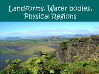
Landforms and bodies of water. Shaping our world. Land surface and shaded topography. This MODIS image is based on surface observations collected from June through September 2001 and combined, or composited, every eight days Credits: NASA Goddard Space Flight Center; Image by Reto St.

E N D
Landforms and bodies of water Shaping our world
Land surface and shaded topography This MODIS image is based on surface observations collected from June through September 2001 and combined, or composited, every eight days Credits: NASA Goddard Space Flight Center; Image by Reto St
Glaciers masses of moving ice Bering glacier
Canyon - A narrow chasm with steep cliff walls, cut into the earth by running water
Plateau - an elevated area of flat land The western part of the Roan Plateau is dissected by the canyon of the East Fork of Parachute Creek.
Valley - an elongated lowland between ranges of mountains or hills, often having a river or stream running along the bottom Yosemite Valley, in Yosemite National Park, California. The granite cliffs were carved by glaciers.Photograph courtesy of NASA. This photograph shows Yosemite Valley, in Yosemite National Park, California. The granite cliffs were carved by glaciers. Photograph courtesy of NASA.
mesa - elevated area of land with a flat top and sides that are usually steep cliffs. It takes its name from its characteristic table-top shape.
Plain a flat stretch of land Once blanketing the entire Midwest prairie, buffalo (bison) were hunted mercilessly. Thanks to conservation measures, small herds are making a comeback in wildlife refuges.
Great Plains Cattle grazing in Kansas
a plain formed by sediment dropped by a river when it floods Flood Plain –
Peninsula Land with water on three sides Florida Peninsula Korean Peninsula
point or head of land projecting into a body of water Cape - Cape Town, South Africa Satellite image of Cape Cod, MassachusettsNASA
Cape Hatteras Lighthouse before move, North Carolina October 1989
Isthmus - A narrow strip of land that connects two larger areas. The isthmus of Panama allows for the shortest canal route between the Atlantic and Pacific oceans
Isthmus Lying roughly midway between Tasmania and Antarctica, Macquarie Island is a long, narrow, steep-sided plateau only 34 kilometres long and 5.5 kilometres wide at its broadest point.
Canal -man-made waterway s (above) A freighter passes through the Panama Canal.(right) USS Theodore Roosevelt transiting the Suez Canal on its way to the Persian Gulf in mid-January 1991.
island an area of land completely surrounded by water Infant island of Surtsey, Iceland (formed 1963-1967)
a group of islands Archipelago - Hawaiian Islands Satellite view of the Florida Keys
A volcanic island forms in deep tropical waters, giving coral polyps a foundation to grow on. In time, the volcano becomes dormant and the island begins to subside. Coral reefs, originally fringing the edges of the island, become a barrier reef outlining the contour of the original coastline. After the original island slips entirely beneath the waves, all that is left is a coral atoll . Atoll
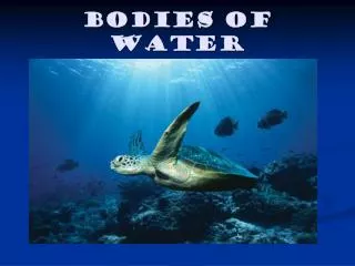
Bodies of Water Descriptions of bodies of water are not always precise. For example, a “gulf” may be smaller than a “bay” or a “sea” may be smaller than a “lake.”
a large natural stream of water emptying into an ocean, lake, or other body of water River - Sierra Nevada River The Usumacinta River in Guatemala meanders through the Lacandon Forest
Delta - a low triangular area where a river divides before entering a larger body of water (above) The Mississippi River delta (left) This view from the southeast overlooks the green expanse of the Nile delta, with the Suez Canal and portions of the Red Sea in the background. The delta begins to fan out around Cairo, about 160 km inland near the picture's right edge.
Strait - a narrow body of water that connects two larger bodies of water (above)The Bosporus connects the Black Sea with the Sea of Marmara in the center of this view of northwest Turkey.(right)The Strait of Messina is between the island of Sicily and the Italian peninsula.
A broad strait, especially one that connects two seas Channel - The English Channel is the part of the Atlantic Ocean that separates the island of Great Britain from northern France, and joins the North Sea to the Atlantic. United Kingdom France
Chesapeake Bay watershed This satellite view of Chesapeake Bay shows a large inlet of the Atlantic Ocean, long famous for the bounty of oysters and crabs pulled from its muddy waters. The bay's well-being depends on the health of the waterways that empty into it. Antipollution signs on waterways many miles from the bay warn potential polluters that they are in the "CHESAPEAKE BAY DRAINAGE."
Bay - part of a lake or ocean that is partially enclosed by land The Hudson Bayis in north-central Canada A narrow band of fog rolls into San Francisco from the Golden Gate in northern California
Harbora safe anchorage Located on the highly populated Hawaiian island of Oahu just west of Honolulu, Pearl Harbor is the historic center of events on ‘the day that will live in infamy’—December 7, 1941—when the Japanese fleet launched a surprise air attack on Pearl Harbor and other strategic military targets on Oahu.
Fjord - A long, narrow arm of the sea, usually formed by entrance of the sea into a deep glacial trough.
Gulf- part of an ocean or sea that is partially enclosed by a curving coastline The Gulf of Mexico (above) is the largest gulf and covers an area of 596,000 square miles. (left) From Persian Gulf on the northeast side of the Arabian peninsula and through the Strait of Hormuz into the Gulf of Oman huge supertankers transport more than half of the world’s supply of petroleum.
Gulf – part of an ocean that extends so that it is surrounded by land on three sides.
(left)The Sea of Galilee and the Dead Sea to its south both lie astride the great Dead Sea fault, a strike-slip fracture akin to the San Andreas fault. Sea - A relatively large body of salt water completely or partially enclosed by land The Black Sea can only be entered through the Bosporus and Dardanelles straits in Turkey.
Ocean - one of the great bodies of water that covers 70% of the earth’s surface
links • http://www.bluewatr.de/karten/thumbs/panama-canal-!.jpg • http://www.earthwatch.com/SKYWATCH/images/IRGULF3D.jpg • http://www.fpif.orgg/papers/mideast/mideast_oil.jp • http://www.graman.net/amorina/kart-st.jpg • http://www.mideastnews.com/pgulfmap.gifhttp://seawifs.gsfc.nasa.gov/SEAWIFS/IMAGES/SEAWIFS/S1998196102555.L1A_HROM.BlackSea.jpghttp://home.wanadoo.nl/~schoelink/serengeti%20plains.jpg • http://tribe.ulm.edu/~indsa/images/indiamap.gif • http://www.stugna.kiev.ua/locia/prakticheskaya_locia/blacksea.jpg • http://www.r-arcticnet.sr.unh.edu/Tiles/arctic1.gif • http://go.hrw.com/atlas/norm_map/oceans.gif • http://www.photolib.noaa.gov/historic/nws/wea00815.htm • http://www.refocus-now.com/Stock/Travel/images/Due%20North%20Gallery%20Mountain%20Range%20and%20Lake.jpg • http://www.c-span.org/images/guide/international/panama/panama1.jpg • http://www.cnn.com/TECH/science/9806/30/clams.yoto/isthmus.jpg • http://www.lib.utexas.edu/maps/middle_east_and_asia/korea2001.jpg • http://en.wikipedia.org/wiki/Flood_plain • http://www.dpchallenge.com/image.php?IMAGE_ID=134077 • http://biozymeag.com/images/LiberalFeeders/LF%20005.jpg