Download
1 / 29
290 likes | 426 Views
This overview dives into the fundamentals of plate tectonics, detailing how Earth's crust is divided into approximately twelve major plates that move due to the convection currents in the asthenosphere. It covers different types of plate boundaries—convergent, divergent, and transform—along with their geological impacts, including earthquakes, mountain formation, and volcanic activity. The section also discusses Alfred Wegener's early observations regarding continental drift, supported by fossil and rock evidence, ultimately leading to the modern understanding of plate movements.

E N D
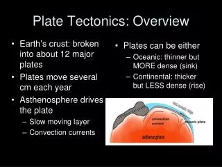
Plate Tectonics: Overview • Earth’s crust: broken into about 12 major plates • Plates move several cm each year • Asthenosphere drives the plate • Slow moving layer • Convection currents • Plates can be either • Oceanic: thinner but MORE dense (sink) • Continental: thicker but LESS dense (rise)
Table of Contents:Types of Plate Boundaries Convergent boundaries : Compression forces push plates together Divergent boundaries: Tension forces move plates apart Transform Plate boundaries: Shearing forces cause plates to slide against each other (opposite directions or same direction @ different rates)
Convergent Boundary Type 1 • Continental—oceanic: denser oceanic crust subducts under continental crust. • Oceanic plate melts as it is driven down, less dense material punches through continental plate to create volcanoes and/or mountains • Forms a subduction zone and oceanic trench • Earthquakes occur as plate is subducted. • Ex: Andes Mtns and Peru-Chile trench • animation of the processes at a destructive plate boundary
Convergent Boundary Type 2 Oceanic—oceanic: one subducts creating a VERY deep trench and an island arc Ex. Kuril Islands and Marianas Trench: plunges deeper into the Earth's interior (~11,000 m) than Mt Everest, the world's tallest mountain, rises above sea level (~8,854 m).
Island arcs (archipelagos) are created along plate boundaries! • Hot spots (like Hawaii) are located within the margins of plates, @ center, at plate boundaries (everywhere) magma pushes to surface • Do NOT confuse the • creation of islands at • convergent boundaries with • islands created at hot spots! • Hotspot animation
Convergent Boundary Type 3 • Continental—Continental: Both resist subduction • Land buckles/folds upward to create fold mountains • No volcanic activity but major earthquakes often occur due to collision.Ex: Himalayas: Indo-Australian and Eurasian PlateThe Making of: the Himalayas
Divergent Plate boundaries Processes: Hot magma rises to fill the 'gap' creating new crust and mountain ranges to form the mid-ocean ridge. Both earthquakes and volcanoes occur at this type of boundary. Rising magma can build up above ocean surface to create a volcanic island (for example Surtsey, Iceland). (ex. North American and Eurasian Plate form the Mid-Atlantic Ridge)animation
Transform Plate boundaries • Movement: two plates move past each other crust is neither created or destroyed Processes: • Shearing forces build btw. the rock • Pressure builds b/c of friction between the plates, slipping releases energy = earthquake.Example: San Andreas Fault (N. American + Pacific Plates)
2 oceanic plates or Oceanic/continental subduction
Review • Name the type of plate boundaries • Name the plates: continental or oceanic • Name resulting features or earthquakes
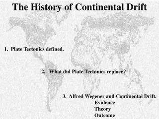
Wegener:Early Observations • German Scientist Alfred Wegener (1912) • proposed the idea of moving continents • scientific hypothesis based on fossil evidence, rock & mineral formations
Evidence from Rock Formations • Similar rock types on opposite sides of the Atlantic Ocean. • Appalachian Mountains in the US identical to rock in Greenland and Europe.
Fossil Evidence: Reptiles • Lystrosaurus: • Early Triassic Period (250 mya) • Land Animal • Antarctica, India, S Africa • Cynognathus: • Late Triassic Period • “Mammal-like reptile” • Land Animal • S Africa, South America, China, Antarctica
Climate Evidence: Ferns & Coal • Certain climates support diff fern types • Land connections were proved by same fossils on different continents • Coal in Northern US originated in an equatorial climate but drifted North over millions of years
Why wasn’t it accepted? • Problems with his theory: • Couldn’t explain how large land masses were pushed such great distances • Didn’t explain how continents moved through the solid crust
Accepted Today because: • Know that asthenosphere has convection currents • Currents push magma which then pushes plates • Plates move at different rates • Not all pieces of plate move at same rate or same direction as the plate in general!
Age of Rock • Rock NEAR ocean ridge= YOUNGER • Rock FAR from ocean ridge= OLDER • Oceanic rocks are relatively young compared to continental rocks—>3.8 billion years old but oceanic is recycled @ subduction zones • Thickness increases with distance from ridge
Magnetism & Seafloor • Earth’s magnetic field generated by flow of molten iron in outer core (Fe)compass • Flow changes magnetic reversal compass point S • Oceanic crust basaltic rock-contains large amts of Fe-bearing minerals MAGNETIC! • Ocean floor shows record of past reversals using magnetometers under water “strips” along seafloor • “strips” are mirror images on either side of ridge symmetrical!! WOW!
When iron cools it is magnetized by the magnetic field of the earth. • So the magnetic field of the sea floor at any time is aligned with the Earth's magnetic field. • But the Earth's magnetic field reverses every several thousand years and so when that happens there is new material on the sea floor which is magnetically orientated differently than the older material. • This discovery led to the understanding that we can study rock samples far from ridge and understand what core was like/magnetic polarity millions of years ago.
Isochron • Isochron imaginary line on map showing points that have same age (formed @ same time)
Seafloor Spreading • New oceanic crust • formed @ ocean ridges • destroyed @ deep-sea trenches • Magma forced to crust along ridge b/c hotter and less dense than mantle • Fills gap of spreading ridge • Magma solidifies ocean floor • Continents like passengers ride along while ocean crust slowly moves