Download
1 / 25
370 likes | 855 Views
Chapter 15. VIEWSHEDS AND WATERSHEDS 15.1 Viewshed Analysis 15.2 Parameters of Viewshed Analysis Box 15.1 Tools for Selecting Viewpoints Box 15.2 Setting Parameters for Viewshed Analysis 15.3 Applications of Viewshed Analysis 15.4 Watershed Analysis Box 15.3 Watershed Boundary Dataset

E N D
Chapter 15. VIEWSHEDS AND WATERSHEDS 15.1 Viewshed Analysis 15.2 Parameters of Viewshed Analysis Box 15.1 Tools for Selecting Viewpoints Box 15.2 Setting Parameters for Viewshed Analysis 15.3 Applications of Viewshed Analysis 15.4 Watershed Analysis Box 15.3 Watershed Boundary Dataset 15.4.1 Filled DEM 15.4.2 Flow Direction 15.4.3 Flow Accumulation 15.4.4 Stream Network 15.4.5 Stream Links 15.4.6 Area-wide Watersheds 15.4.7 Point-based Watersheds Box 15.4 Snapping Pour Points 15.5 Factors Influencing Watershed Analysis 15.6 Applications of Watershed Analysis Key Concepts and Terms Review Questions
Applications: Viewshed and Watershed Task 1: Perform Viewshed Analysis Task 2: Create a New Lookout Shapefile for Viewshed Analysis Task 3: Delineate Area-wide Watersheds Task 4: Derive Upstream Contributing Areas at Pour points Challenge Question References
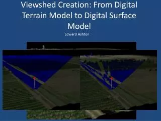
Figure 15.1 A viewshed example.
Figure 15.2 A sightline connects two points on a TIN in (a). The vertical profile of the sightline is depicted in (b). In both diagrams, the visible portion is shown in white and the invisible portion in black.
Figure 15.3 A viewshed based on one viewpoint in (a) has two categories: 0 for not visible, and 1 for visible. A viewshed based on two viewpoints in (b) has three categories: 0 for not visible, 1 for visible from one viewpoint, and 2 for visible from both viewpoints.
Figure 15.4 In (a), cells of an elevation raster are divided into visible (darker symbol) and invisible (lighter symbol) from the viewpoint located at the elevation of 918 in a viewshed analysis. The sightlines in (b) suggest that the viewshed analysis result can vary depending on where the target point is supposed to be located within the cell. The cell at row 2, column 6 is classified as visible in (a). But the sightline shows that the center of the cell is actually invisible to the viewpoint.
Figure 15.5 The increase of the visible areas from (a) to (b) is a direct result of adding 20 meters to the height of the viewpoint.
Figure 15.6 The difference in the visible areas between (a) and (b) is due to the viewing angle: 00 to 3600 in (a) and 00 to 1800 in (b).
Figure 15.7 The difference in the visible areas between (a) and (b) is due to the search radius: infinity in (a) and 8000 meters from the viewpoint in (b).
Figure 15.8 The flow direction of the center cell in (a) is determined by first calculating the distance-weighted gradient to each of its eight neighbors. For the four immediate neighbors, the gradient is calculated by dividing the elevation difference between the center cell and the neighbor by 1. For the four corner neighbors, the gradient is calculated by dividing the elevation difference by 1.414. The results in (b) show that the steepest gradient, and therefore the flow direction, is from the center cell to the right cell (+8).
Figure 15.9 This illustration shows a filled elevation raster (a), a flow direction raster (b), and a flow accumulation raster (c). Both shaded cells in (c) have the same flow accumulation value of 2. The top cell receives its flow from its left and lower-left cells. The bottom cell receives its flow from its lower-left cell, which already has a flow accumulation value of 1.
Figure 15.10 A flow accumulation raster, with darker symbols representing higher flow accumulation values.
Figure 15.11 (a) a flow accumulation raster; (b) a stream network based on a threshold value of 500 cells; and (c) a stream network based on a threshold value of 100 cells.
Figure 15.12 The stream network from the 1:24,000-scale digital line graph for the same area as Figure 15.11.
Figure 15.13 To derive the stream links, each section of the stream network is assigned a unique value and a flow direction. The inset map on the right shows three stream links.
Figure 15.14 A stream link raster includes reaches, junctions, flow directions, and an outlet.
Figure 15.15 Area-wide watersheds.
Figure 15.16 Point-based watersheds (shaded area).
Figure 15.17 If a pour point (black circle) is not snapped to a cell with a high flow accumulation value (dark cell symbol), it usually has a small number of cells (shaded area) identified as its watershed.
Figure 15.18 When the pour point in Figure 15.17 is snapped to a cell with a high flow accumulation value (i.e., a cell representing a stream channel), its watershed extends to the border of a USGS 1:24,000-scale quadrangle map and beyond.
Figure 15.19 The pour point (black circle) in (a) is located along a stream section rather than at a junction. The watershed derived for the pour point is a merged watershed, shown in thick black line in (b), which represents the upstream contributing area at the pour point.
Figure 15.20 DEMs at a 30-meter resolution (a) and a 10-meter resolution (b).
Figure 15.21 Stream networks derived from the DEMs in Figure 15.20. The stream network derived from the 30-meter DEM (a) has fewer details than that from the 10-meter DEM (b).
Figure 15.22 The gray raster lines represent stream segments derived using the D8 method. The thin black lines are stream segments from the 1:24,000-scale DLG. The two types of lines correspond well in well-defined valleys but poorly on the bottomlands.
U.S. Clean Water Act http://www.epa.gov/watertrain/cwa/ Watershed Boundary Dataset http://www.ncgc.nrcs.usda.gov/branch/gdb/products/watershed/index.html Hydrologic Engineering Center (HEC) of the U.S. Army Corps of Engineers: Hydrologic Modeling System (HMS) http://www.hec.usace.army.mil/ USGS National Water Information System http://nwis.waterdata.usgs.gov/nwis GIS Data Depot http://www.geocomm.com Federal Standards for Delineation of Hydrologic Unit Boundaries http://water.usgs.gov/wicp/acwi/spatial/index.html