Download
1 / 14

E N D
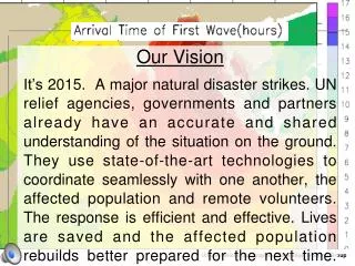
Our Vision It’s 2015. A major natural disaster strikes. UN relief agencies, governments and partners already have an accurate and shared understanding of the situation on the ground. They use state-of-the-art technologies to coordinate seamlessly with one another, the affected population and remote volunteers. The response is efficient and effective. Lives are saved and the affected population rebuilds better prepared for the next time. United Nations Geographic Information Working Group
UN Spatial Data Infrastructure (UNSDI) Gazetteer Framework Project Suha ÜLGEN ulgen@un.org Senior Advisor on Spatial Data Infrastructure Co-chair of the United Nations Geographic Information Working Group Office of the Assistant Secretary-General and Chief Information Technology Officer New York, USA 26th Session of UNGEGN - Vienna, 2-6 May 2011 United Nations Geographic Information Working Group
Realizing our vision Define data standards needed to integrate operations between UN agencies, governments, and partners. Ensure availability of data in these standard formats detailing the facilities, resources, vulnerabilities, infrastructure, and gaps in high-risk countries. Identify key roles, types of information, and technologies pertaining to extra-institutional actors. Based on these findings, design public UN Crisis Information Management application programming interfaces (APIs) – compliant with the aforementioned data standards -- to allow real-time interaction between UN agencies and extra-institutional actors. Drive adoption of the data standards by supporting UN agencies in their efforts to bring their systems up to the level of compliance required to implement the public APIs. United Nations Geographic Information Working Group
The situation today Discover Access Extract, Transform & Load Understand Use Time and effort There’s no metadata! How old is this data & who collected it ? OK I think I have the right data, let’s make some maps!! Where can I find a list of villages? Can you send me your list of affected villages? I’ll have to ask my boss Who has up-to-date admin. boundaries? How come these three versions of admin areas use different boundaries? There’s no metadata What’s the datum? This health centre is supposed to be in admin area A but is mapped to a village in Area B. Which one is right? Is Mytown in this dataset the same as Yourtown in that data set? United Nations Geographic Information Working Group
2015 Discover/Access/Extract, Transform & Load Use and re-use Understand • UNSDI Gazetteer Framework Project developed by • Office of the Assistant Secretary-General and Chief Information Technology Officer (ASG/CITO) of the UN Secretariat • and • Commonwealth Scientific and Industrial Research Organization (CSIRO) of Australia United Nations Geographic Information Working Group
UNSDI Gazetteer Framework Project Objectives • Establish a services infrastructure enabling online (web) access to and improved use of published gazetteers • Establish a framework for improved description of information resources to support evolution of the shared services infrastructure and its content • Develop a reference architecture to guide the growth, and local exploitation, of a shared services infrastructure United Nations Geographic Information Working Group
The problem... • Application: • “When I select an object on the map I get a reference I can re-use” • record in my dataset • find related resources for the object • tell someone else what I’m referring to United Nations Geographic Information Working Group
Gazetteer service concept Type? Application “Foo”, type=Local Government, src=… Gazetteer Admin schema Model and vocabulary registry SDMX Get admin.area Get admin.parent=“foo” United Nations Geographic Information Working Group
An application example Sirens Storm Another City / Province / Country One City / Province / Country Radio Earthquake Television Tsunami Fax Fire Cell / SMS Volcano Common Alerting Protocol (CAP) United Nations Geographic Information Working Group
CAP gazetteer reference Sirens Radio Television Fax Cell / SMS Any City / Province / Country Storm CAP Earthquake Tsunami Fire Volcano United Nations Geographic Information Working Group
3-year work plan • Build • Identify key data sources and user needs for re-use • Model and harvest a “resource view” of data sources • Prototype gazetteer and underlying model registry • Review prototypes for key re-use requirements • Refine • Design of content and tools based on feedback • Propose simplifications • Sustain with stable production version • Five workstreams – shared models; community agreements; infrastructure; tools & methods; information products United Nations Geographic Information Working Group
Gazetteer Framework partners UN • UNGEGN • Global Pulse Project (Secretary-General’s Office) Non-UN • Member State organizations • CSIRO United Nations Geographic Information Working Group
Advantages to participants • Declaration of dataset as authoritative • ISO-compliant documentation • Usage statistics • Crowdsourced inputs for revisions • Updated registry of revisions • Cloud hosting option under UN’s auspices • Technical support on building system interfaces • User Committee membership United Nations Geographic Information Working Group
Thank you Suha ÜLGEN UNGIWG Co-chair Office of the ASG/CITO, New York ulgen@un.org www.ungiwg.org United Nations Geographic Information Working Group