Download
1 / 15
190 likes | 428 Views
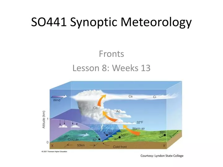
SO441 Synoptic Meteorology. Fronts Lesson 8: Weeks 13. Courtesy: Lyndon State College. What is a front ?. Early meteorological theory thought that “fronts” led to development of low pressure systems (cyclones)

E N D
SO441 Synoptic Meteorology Fronts Lesson 8: Weeks 13 Courtesy: Lyndon State College
What is a front? • Early meteorological theory thought that “fronts” led to development of low pressure systems (cyclones) • However, in the 1940s, “baroclinic instability theory” found that cyclones can form away from fronts, then develop frontal features • So what is a front? • Several definitions exist: • Zone of “enhanced” temperature gradient (but what constitutes “enhanced”?) • Sharp transition in air masses • The Great Plains dry line is a sharp change in air masses but is not considered a front • Zone of density differences • But density is driven by not only temperature but also moisture and pressure • Example: • Early a.m. clear skies, NW winds, & cold air over Oklahoma, and cloudy skies, SE winds, and warm air over Arkansas. A cold front separates the two. • By mid-day, solar radiation has strongly heated the air over Oklahoma, and it is now warmer than the moist air over Arkansas. Has the front disappeared? Changed to a warm front?
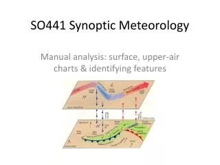
A basic definition • Following Lackmann (2012), we will use the following definition of a front: • A boundary between air masses • Recognize that all boundaries between air masses may not be fronts • Examples: semi-permanent thermal gradients locked in place by topographic boundaries, land-sea contrasts • How do we proceed? • In weather chart analyzes, be sure to analyze temperature • The important boundaries will then be evident on the chart
Properties of fronts • Most defining property (on a weather map): enhanced horizontal gradients of temperature • Usually long and narrow: synoptic scale (1000 km) in the along-front direction, mesoscale (100 km) in the across-front direction • Other properties: • Pressure minimum and cyclonic vorticity maximum along the front • Strong vertical wind shear • Exists because of horizontal temperature gradients (required by “thermal wind balance” • Large static stability within the front • Ageostrophic circulations • Rising motion on the warm side of the frontal boundary • Sinking motion on the cool side of the boundary • Greatest intensity at the bottom, weakening with height • Fronts are mostly confined near the surface, but not always • Upper-level fronts, i.e. gradients of temperature aloft, are associated with strong vertical wind shear • Clear-air turbulence and aviation hazards often occur there
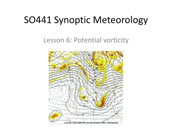
Example of a front: 17 Nov 2009 Potential temp (k) Sea-level pressure (mb) Cross-section of potential temp (k) and wind 950-mb relative vorticity (s-1)
Frontogenesis function • To examine whether a front is strengthening or weakening, can look at the “Frontogenesis Function” • When F is positive, frontogenesis is occurring • When F is negative, frontolysis is occurring • F allows for examination of the different physical mechanisms that lead to changes in temperature gradients • Let’s examine each term in turn
Shearing term • Shear frontogenesis describes the change in front strength due to differential temperature advection by the front-parallel wind component • Along the cold front, both and are negative, giving a positive contribution to F(note the rotation of the coordinate system!!) • This means cold-air advection in the cold air, and warm-air advection in the warm air. t=0 t=+24 Example: positive contribution to F along the cold front: shearing frontogenesis
Shearing term • Shear frontogenesis describes the change in front strength due to differential temperature advection by the front-parallel wind component • Along the warm front, is positive, but is negative, giving a negative contribution to F(again note the rotation of the coordinate system!!) • This means along the warm front, shearing acts in a frontolytical sense t=0 t=+24 Example: negative contribution to F along the warm front: shearing frontolysis
Confluence term • Confluence frontogenesis describes the change in front strength due to stretching. If the isotherms are stretching (spreading out), there is frontolysis. If they are compacting, frontogenesis is occurring. • Along the front, is negative. Here is also negative, giving a positive contribution to F(again note the rotation of the coordinate system!!) • This means along the front, confluence acts in a frontogenetical sense t=+24 t=0 Example: positive contribution to F along the front: confluence frontogenesis
Tilting term • Near the Earth’s surface, vertical motion is usually fairly small • But higher aloft, it can be strong • Thus tilting usually acts to strengthen fronts above the Earth’s surface • Consider the following example: here, is positive (temperature decreases above the surface), and is also positive (rising motion in the cold air, sinking in the warm air) z z y y Example: positive contribution to F along a front: tilting
Diabatic heating term • The differentialdiabatic heating term takes into account all diabatic processes together: • Differential solar radiation, differential surface heating due to soil characteristics, differential heat surface flux • One example: differential solar radiation • Assume the diabatic heating rate in the warm air exceeds the diabatic heating rate in the cold air • In that example, would be positive, and F positive Example: positive contribution to F along a front: differential diabatic heating
Frontal circulations • Important terminology: • Thermally direct: warm air rises, cold air sinks • Thermally indirect: warm air sinks, cold air rises • Ageostrophic: departure from geostrophic flow • Because of the strong temperature contrasts along fronts, there are often thermally direct circulations: warm air rises, cold air sinks • The rising / sinking motions are ageostrophic, and by themselves, act to weaken fronts • See the tilting term example • Also, lifting air cools it (so the warm air cools) and sinking air warms (so the cold air warms) • But when ageostrophic circulations act together with geostrophic flow above the surface, they can act to strengthen the front at the surface Example: geostrophic and ageostrophic flows strengthening a front at the surface
Cold fronts • Defined as: • Clear advance of cold airmass with time • Usually characterized by: • Abrupt wind shift from a southerly component to a westerly or northerly component • Pressure falls before, then rises after, passage • Showers and sometimes thunderstorms • Two types: • Katafront, with precipitation ahead of the front • Usually preceeded by a cold front (or boundary) aloft • Front slopes forward • Anafront, with precipitation behind the front • Front slopes backward Arrows represent direction of upper-level winds; hatching in katafront figure indicates precipitation area Anafront Katafront
Warm fronts • Defined as: • Clear advance of warm airmass with time • Usually characterized by: • Gradual wind shift from easterly to southerly during passage • Turbulent mixing along the passage • Gives rise to risk of tornadic thunderstorms along front • Shallow vertical slope
Occluded fronts • Cyclogenesis is favored along frontal boundaries • Rich area of cyclonic vorticity • Rising motion (and vorticity stretching) • Circulation around surface cyclone moves air masses • We call these boundaries fronts • Cold front moves faster than warm front • What happens when the cold front “catches up” to the warm front? • The resulting boundary (between cold and not so cold air) is called an occluded front • Noted on surface charts by purple symbol with both triangles and semi-circles in same direction