Download
1 / 12
120 likes | 287 Views
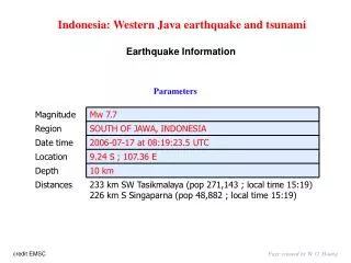
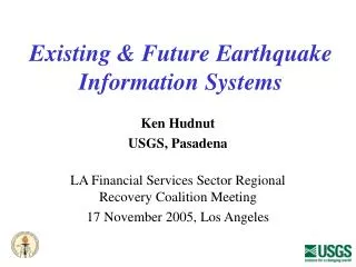
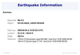
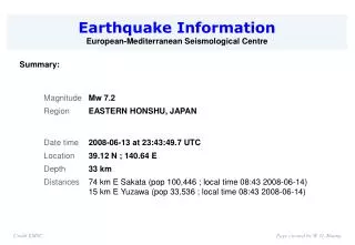
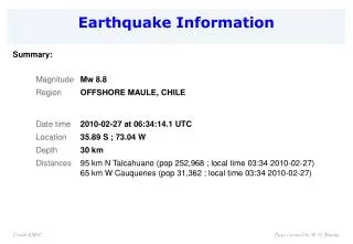
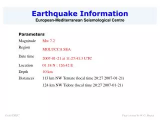
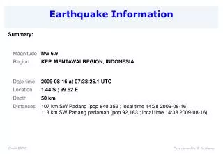
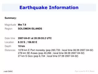
Earthquake Information. Summary:. Page created by W. G. Huang. credit EMSC. 2007-04-01 at 20:39:55.2 UTC Mw=7.9. Page created by W. G. Huang. Quick Moment Tensors solutions. 5300 km. 2007-04-01 at 20:39:55.2 UTC Mw=7.9. Page created by W. G. Huang. Tectonic summary.

E N D
Earthquake Information Summary: Page created by W. G. Huang credit EMSC
2007-04-01 at 20:39:55.2 UTC Mw=7.9 Page created by W. G. Huang
Quick Moment Tensors solutions 5300 km 2007-04-01 at 20:39:55.2 UTC Mw=7.9 Page created by W. G. Huang
Tectonic summary Location of the earthquakes relative to Australia. Regional schematic plate boundary map Page created by W. G. Huang Credit USGS
Regional topographic map showing the Solomon Islands, and the surrounding trenches The Solomon Islands are located between 156° and 170° E longitude and 5° and 12° S latitude, and form a long (1200 km), thin (250 km) archipelago oriented NW - SE. They are positioned in the collisional zone between the Australian and Pacific plates, and consist of a complex series of crustal units. Deep ocean lies to the north-east and south-west. The islands are geologically bound by two trenches: the Vitiaz trench in the north-east, and the New Britain-San Cristobal trench in the south-west. The Vitiaz trench is over 3000 km long, with depths up to 6000 m (6 km). The New Britain-San Cristobal trench reaches depths of up to 9000 m (9 km). Subduction (or sinking) of the Australian plate beneath the Solomon Island occurs along the New Britain-San Cristobal trench. Page created by W. G. Huang Credit National Geographic
The Solomon Islands is a nation in Melanesia, east of Papua New Guinea, consisting of nearly one thousand islands. Together they cover a land mass of 28,400 square kilometres (10,965 sq mi). The capital is Honiara, located on the island of Guadalcanal. The Solomon Islands are believed to have been inhabited by Melanesian people for thousands of years. The United Kingdom established a protectorate over the Solomon Islands in the 1890s. Some of the most bitter fighting of World War II occurred in the Solomon Islands campaign of 1942-45, including the Battle of Guadalcanal. Self-government was achieved in 1976 and independence two years later. The country remains a Commonwealth Realm. Since 1997 ethnic violence, government misconduct and crime have undermined stability and civil society. In June 2003 an Australian-led multinational force, the Regional Assistance Mission to the Solomon Islands (RAMSI), arrived to restore peace and disarm ethnic militias. Solomon Islands Map the earthquake struck near Gizo credit NEWS.com.au Page created by W. G. Huang
Areas affected by the main and aftershock earthquakes Page created by W. G. Huang Credit USGS
Houses float in sea of devastation A transport boat is grounded in Gizo, in the Solomons. the first aerial footage shows the destruction in Gizo left by yesteray's tsunami credit NEWS.com.au Page created by W. G. Huang
Tsunami Event - April 1, 2007 Solomon Islands credit ReliefWeb
Earthquake and tsunami wipe out whole communities in Solomons · 8.0 magnitude shock kills 12, with many missing · 10m wave washes away whole villages Walter Nalangu in Honiara, and ReutersTuesday April 3, 2007 A powerful earthquake and tsunami struck the tiny Solomon Islands yesterday, swallowing entire villages and killing 12 people, with many more reported missing. The quake, with a magnitude of at least 8.0, leveled buildings and damaged a hospital on the island of Gizo, northwest of the Solomons capital, Honiara. A tsunami described by a witness as being the height of a two-storey building sucked homes into the sea as thousands of panicked residents fled for higher ground. At least seven people died in Gizo, many trapped in their homes when waves swept through the town. Other bodies could be seen but not reached because of huge waves crashing ashore. "The wave was up to 10 metres (32ft) high in some villages," government spokesman Alfred Maesulia told Reuters. "Some villages have been entirely washed away." credit The Guardian Page created by W. G. Huang
Solomons' disaster management authorities said two-way radio communications problems were preventing an assessment of damage on the island of Simbo, where residents reported waves hitting houses 200m inland. Geological agencies, including those in Australia and Japan, put the magnitude of the quake at 8.1 while the US Geological Survey (USGS) revised its earlier estimate to 8.0. The initial tremor was followed around seven minutes later by a second one, centred further to the west, of magnitude 6.7, USGS said. Gary Gibson, who chairs the International Seismological Centre executive committee, said the quake was the biggest to hit the Solomons since 1900. "An earthquake of this size would involve a rupture of more than 10,000 square kilometres of fault area ... about 100 kilometres by 100 kilometres," he said. Kevin McCue, director of the Australian Seismological Centre, said there was a strong chance that there would be more earthquakes in coming days on an undersea trench west of the Solomons. "This region typically has double earthquakes, six sets of them since 1907," Mr McCue said, adding residents and rescue teams should be on alert for more quakes of up to magnitude 7.5. The Solomons lie on the so-called Pacific Ring of Fire where volcanic activity and earthquakes are fairly common. credit The Guardian Page created by W. G. Huang
Research animations of the April 1, 2007 Solomon Islands tsunami propagation created with experimental runs of the MOST tsunami forecast model and including DART™ buoy data. Yellow squares indicate DART™ buoy locations. Propagation in the Pacific Ocean (14.2 MB animation) The animation and graphic display qualitative and quantitative information about the tsunami propagation including tsunami wave interaction with ocean floor bathymetric features, and neighboring coastlines. The tsunami radiation pattern is indicated with color coded information about the maximum wave height at different locations throughout the Pacific Ocean. The timer and moving yellow squares indicate time elapsed since time of the earthquake, providing an estimate of tsunami arrival time at different locations (left). Please note that part of the 1 minute data of 52403 DART is missing and is displayed as a straight line on the animation plot. Maximum wave height distribution Page created by W. G. Huang credit NOAA / NOAA Center for Tsunami Research