
Liberia
E N D
Presentation Transcript
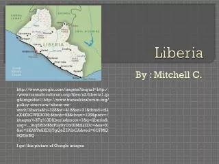
Liberia By : Mitchell C. http://www.google.com/imgres?imgurl=http://www.transafricaforum.org/files/u2/liberia1.jpg&imgrefurl=http://www.transafricaforum.org/policy-overview/where-we-work/liberia&h=328&w=418&sz=31&tbnid=cLleX4K9GWK0OM:&tbnh=98&tbnw=125&prev=/images%3Fq%3Dliberia&zoom=1&q=liberia&usg=__9tq5RlbtBSrPLy9yOxUiMzLlZDc=&sa=X&ei=3KA9TeSXDIjTgQeZ7PibCA&ved=0CFMQ9QEwBQ I got this picture of Google images
About the groups 1263%26bih%3D937%26tbs%3Disch:1&um=1&itbs=1&iact=rc&dur=250&oei=dKE9Tcj6GYrWgQfl1ZC6CA&esq=1&page=1&ndsp=30&ved=1t:429,r:8,s:0&tx=82&ty=139 I got this picture of Google images In Liberia, African tribes consist of 95% of the population. There are about 28 ethnic groups in Liberia, all have their own language. The tribes are divided into three different groups: the Mande people in the north and far west, the Kru tribes and also the Krahn in the east and southeast, and the Mel in the northwest.
The largest groups are the Kpellé, Bassa, Gio, Kru, Grebo, Mano, Krahn, Gola, Gbandi, Loma, Kissi, Vai, and Bella. From the US there were slaves that are descendents of immigrants, there is about 2.5 % of the population is AmericoLiberian. There are also two tribes that aren’t strictly Liberian: the Mandingo, who are itinerant Muslim traders, and the Fanti fishermen, who come from Ghana and stay a few years at a time in Liberia.
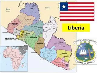
Countries and bodies of water Liberia borders 1&um=1&itbs=1&iact=hc&vpx=142&vpy=273&dur=187&hovh=194&hovw=259&tx=192&ty=170&oei=dKE9Tcj6GYrWgQfl1ZC6CA&esq=1&page=1&ndsp=30&ved=1t:429,r:6,s:0 I got this picture from Google images The states Liberia borders are Ghana, Sierra Leone, and Guinea. The ocean Liberia borders is the North Atlantic Ocean.
The temperature is pretty much the same throughout the year; it is very humid and tropical weather. The temperature is usually around 81 degrees F, with temperatures usually exceeding 97 degrees F and falling below 68 degrees F. The rainfall is about 200 inches a year on the coast and about 80 inches of rainfall more inland.
How Liberia’s climate is affected by climate 937%26tbs%3Disch:1&um=1&itbs=1&iact=hc&vpx=138&vpy=437&dur=875&hovh=192&hovw=262&tx=153&ty=104&oei=DaM9Tbq3Ho73gAfwqtS8CA&esq=1&page=1&ndsp=30&ved=1t:429,r:12,s:0 I got this picture of Google images It affects how most people live and where they live because the hot climate and limited rainfall doesn’t help workers who work with plants or gardens grow because plants need water to survive, but the sunshine does help. Today its tropical rain forests provide the raw material for the country’s large rubber industry.
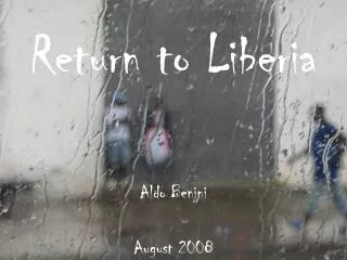
Liberia’s travel destinations 26biw%3D1263%26bih%3D937%26tbs%3Disch:1&um=1&itbs=1&iact=hc&vpx=575&vpy=131&dur=125&hovh=161&hovw=312&tx=170&ty=98&oei=DaM9Tbq3Ho73gAfwqtS8CA&esq=4&page=1&ndsp=30&ved=1t:429,r:3,s:0 I got this picture of Google images Liberia is Africa’s oldest republic but one of the poorest nations, it is struggling after almost 14 years of civil war. This led to about 250,000 deaths. Travelers are currently advised against all but essential travel to Liberia. If Liberia recovers then they can open up tourists and go to Monrovia which is one the beach.
Chief imports and exports rc&dur=688&oei=DqU9TfHdNs_TgQeanqi1CA&esq=1&page=1&ndsp=30&ved=1t:429,r:0,s:0&tx=86&ty=93 I got this picture from Google images The chief exports are diamonds, iron ore concentrates, natural rubber, gum, timber, coffee, cocoa. The chief imports are machinery, transport equipment, manufactures food, live animals, mineral fuels, and lubricants.
Liberia as a colony wElATeqnAs2RgQfhu_3mAg&esq=1&page=1&ndsp=16&ved=1t:429,r:14,s:0&tx=149&ty=75 this picture is from Google images Liberia was once a colony. The nation it was when it was a colony was Nigeria.
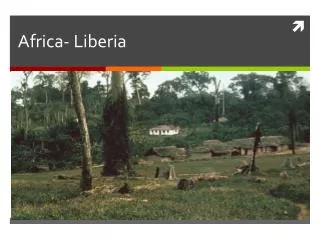
Liberia’s people &dur=422&hovh=240&hovw=210&tx=135&ty=139&oei=R0pATZGQKcOdgQeD9pHbAg&esq=1&page=1&ndsp=24&ved=1t:429,r:0,s:0 this picture is from Google images Most of Liberia’s people live in homes somewhat like what we have here. There are many differences though, the houses are not complex like ours they are smaller and built different.
Physical features =313&oei=nEtATZO2KM6cgQeZkNHkAg&esq=1&page=1&ndsp=25&ved=1t:429,r:21,s:0&tx=142&ty=97 this picture can be found at Google images These physical features include the St. Paul River, St. John River, Cess River, Doube River, and Mt. Nimba. There natural resources that can be used everyday are include iron, timber, gold, diamond, and hydropower. Hydropower is used to power things that can run of hydroelectricity. Liberia has much gold and diamonds so Liberia is a big production of jewelry.
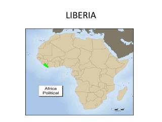
Liberia’s location =1&itbs=1&iact=hc&vpx=953&vpy=164&dur=1078&hovh=180&hovw=280&tx=147&ty=157&oei=eUxATd-oPIz1gAf38PzVAg&esq=2&page=2&ndsp=28&ved=1t:429,r:13,s:26&biw=1259&bih=692m this picture can be found at Google images The latitude is 10 degrees north, 85 degrees west. Liberia is located on the southern part of the west coast of Africa.
Credits dur=515&hovh=119&hovw=160&tx=108&ty=57&oei=IlBATbSuJsKCgAfZu5XZAg&esq=1&page=1&ndsp=28&ved=1t:429,r:8,s:0 picture from Google images A special thanks to Ms. Cotter Pictures from Google images Hope you enjoyed