Download

1 / 46
460 likes | 685 Views
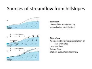
Soil Survey Models of Hillslopes. Discussion & Objectives. Hillslope processes are fundamental determinants of: soil spatial variability, Suitabilities /limitations of soil use, Productivity, etc. An effective soil survey model for uplands will address hillslope processes. Objectives:

E N D
Discussion & Objectives • Hillslope processes are fundamental determinants of: • soil spatial variability, • Suitabilities/limitations of soil use, • Productivity, etc. • An effective soil survey model for uplands will address hillslope processes. • Objectives: • Consider how 2D and 3D hillslope positions are used in soil survey mapping, • Examine a few quantitative GIS-based techniques to partition hillslopes, • Explore an idea for map unit design based on geomorphic position rather than slope class, • Generate discussion and thought about mapping hillslopes.
Formulating hypotheses about hillslope map units 13 map units here?? 5 map units here?
Formulating hypotheses about hillslope map units Summits: distinguish crestvsinterfluve units? Backslopes: distinguish head slope vsnose slope vsside slope units?
Mountainslopes… how many components here? Generally mapped Order 3 – but still must identify components
Summary: possible map units / components on hillslopes Add in stratigraphy to create upper, mid & lower backslope differences; stepped surfaces from erosional cycles; hydropedological effects from above… lots of possible map units and components!
Example: hillslope SSURGO model from NW Mo (only upland units shown)
Using GIS-based models in hillslope mapping • Create spatially distributed hypotheses about soil variability on hillslopes. • Generally rely on Digital Terrain Models • DEMs: USGS; standard 10m • LiDAR (1m common), IFSAR (5m common) • Numerous techniques available. • Focus here on a few examples to illustrate hillslope processes. • Slope • Curvature • Relative position • Wetness Index • Base level • Recommend: ArcSIE, for terrain analyses not available in Spatial Analyst.
Slope maps standard procedure in many areas Start w 10m DEM Create slope map (continuous surface) Categorize into standard classes for the SSA
Use slope map to evaluate hillslope mapping model (a common approach) Is this a useful technique? Any problems or dangers with this technique? Slope class map Soil survey (colored by slope class)
Slope maps: what is “truth”? Variation due to source data, pixel size, neighborhood size of calculation, filtering, etc. Do the class boundaries fit this landscape? 1m LiDAR source 10m NED source We’ll come back to slope issues later…
Curvature Models for HillslopesExample: Skull Lick Cr. watershed (12-digit)Audrain co. MO; “Central Claypan” MLRAlow relief, loess-covered till plain;clayey subsoils; lateral water mov’t
Planiform curvature: nose slopes vs head slopes lighter areas = more negative = concave
2-class Planiform curvature Good headslope – noseslope distinction Broad interfluves: messy. What is “plane”? Try 3rd class, “plane”, centered on 0
Planar areas on broad interfluve summits Still kind of messy on broad summits
Profile curvature: shoulders (darker) vsfootslopes (lighter)
3-class Profile curvature map: Plane interfluves, convex shoulders, concave footslopes/floodplains
Nine-class hillslope model (profile x planiform curvature): pretty busy!
Relative Position • Need to know how a delineation sits relative to its surroundings. • A ridgeline soil should be high relative to the surrounding areas. • A floodplain soil should be low relative to the surrounding areas. • Ridges and floodplains have similar slope gradients, but different relative positions.
DEM vs Relative Position Barry county, SW MO
Skull Cr. Relative Position Skull Cr. DEM Compare these two ridges: low absolute elevation, but high relative position
Floodplains & Terraces of Skull Lick Cr. watershed Relative Position Note terraces: local highs Note rel. pos. about the same in upper reaches as in lower reaches. Elevation Note elevation much higher in upper reaches than in lower reaches.
Multi-component Hillslope ModelsExample: Mexico-Leonard-Armstrong Project Audrain county, Missouri: Mexico soils are on summit interfluves Leonard soils are on headslopes and upper sideslopes, Armstrong soils are on nose slopes and steeper, lower sideslopes Can we quantify this conceptual hillslope model via DEM-derived, individual hillslope models?
Audrain county soil landscape: SSURGO Leonard Mexico Armstrong
Model for headslope / upper sideslope(Leonard soil component) Combines 3 individual models: Slope Relative position Planiformcurvature
Original soil map: Dark green probably overmapped (shouldn’t be on convex slopes). Modeled soil map: Not bad; some stratigraphic problems.
Wetness Index • AKA Compound Topographic Index. • May help identify seep areas, variable source areas, hydric soils, headslopes, etc. • For any pixel, the Wetness Index = ln(As/tanB). • ln = natural logarithm • As = upslope contributing area • Number of upslope pixels draining to this pixel. • tanB = the tangent of the slope angle • % slope of the pixel. • Wetness Index algorithm available in CCE-certified ArcMap extension: • ArcSIE
Wetness Index for dissected loess over till and residuum, central Missouri (MO R floodplain in SE corner)
Wetness Index closeup; contour lines added. Note some contour line bias in Wetness Index.
Base Level • Elevation of streams, interpolated out across the landscape. • As if the uplands were removed. • Height above base level can be useful in geomorphological analysis. • Example: Distinguishing among flood-plain step and/or stream terrace surfaces in W TX. • Using absolute elevation doesn’t work because of the stream gradients. • Sorry, not a hillslope application. • Example for hillslopes (general): distinguishing high-relief uplands from lower-relief uplands. • Indicates differences in stratigraphy, perhaps? • Hypothesis: soils differ between higher-relief uplands and lower-relief uplands.
Base Level calculation: an example 10m DEM for a 3-watershed area in the Missouri Ozarks
Stream lines are simplified Nodes are extracted as points
Elevations of stream points are interpolated across the watersheds, resulting in a Base Level grid. DEM is subtracted from this to create “height above base level” environmental covariate grid.
DEM, vs Height above Base Level grid Precambrian-age igneous knobs; higher local relief, more pronounced. Ordovician-age dissected limestone plateau; lower local relief, more subdued.
Modelers of the world, Unite! • Any digital soil modelers in the house? • How can we help each other? • Sharepoint site (e.g., NGDC) • User Group • ? • Tom D’Avello (Tom.Davello@wv.usda.gov) • NGDC, Morgantown WV • Assistance & coordination of digital soil mapping efforts in NCSS.
A radical proposal:map landscape position, not slope class • Isn’t this what we already do? • We are very good at mapping landscape position. • These are natural individuals that are independent of the observer. • We are not so good at mapping slope class. • These are artificial individuals that are defined arbitrarily from a continuous universe. • The emergence (and use) of the DTM-derived slope model is making us look bad. • e.g., “Your soil map says that this unit is Armstrong loam, 5-9%, but look at all these 3% and 4% areas… and look, here’s a big area that is 10 to 12%...” • Proposal: take slope class out of the map unit name, & replace with landscape position phases. • e.g., Bevier silt loam, crests; Armstrong loam, upper sideslopes, etc.
Consider this quarter-quad of mapping: Did they map by landscape position? Bevier: crests Armstrong 5-9%: upper sideslopes Armstrong 9-14%: lower sideslopes (I can’t tell how they separated eroded vs severely eroded lower sideslopes)
Consider some slope statistics for these map units in this quarter-quad* *for illustration only; should be applied to the entire distribution of these map units. RV_low & RV_high estimated at + and – 1 std. Conclusions: For Bevier, 2-5% is OK but too narrow. For Armstrong 5-9%, range should be lower (e.g., 3-9%). For the 9-14% units, the data do not justify separation from the 5-9% class.
Observe the relationships between current mapping, slope, and landscape position…
Fred’s observations… • Armstrong l, 5-9% contains 3 major landscape positions: • Upper sideslope (dominant) • Crest (minor) • Lower surface (terrace? Stepped surface in till?) • Should these be 3 separate map units? This is a testablehypothesis. • Armstrong 9-14% units are focused on lower sideslopes: • Slope map indicates that these are complex, dissected slopes, crossing several slope classes. • Mapping delineates some but not all of the lower slopes. • Perhaps because mappers were trying to map slope class instead of landscape position? • Based on landscape position and dissected surfaces, separation of these units from the 5-9% unit seems justified. • If slope analysis alone is used, the Armstrong loam 5-9% and 9-14% should be combined. • Armstrong l, 9-14%, eroded and Armstrong cl, 9-14% sev eroded are on the same landscape position. • Are there significant soil differences between these units? This is a testablehypothesis.
Possible approach, & discussion • Benchmark soils project for an upland catena with multiple slope classes. • Incorporate as part of a slope class and landscape position evaluation. • Evaluate the effects of removing slope class from the mu names, and replacing w hillslope position terms. • Discussion • What do you think? • How are you dealing with the impact of DTM-derived slopes on soil mapping? • Can/should this be addressed in the SDJR Project?