Download

1 / 15
150 likes | 166 Views
This data evaluation tutorial focuses on assessing modeled agricultural production yields through a weighted approach comparing simulated and observed results. The tutorial provides step-by-step instructions utilizing GIS software like ArcGIS for analyzing grid-wise and country-wise yield data. The evaluation process involves calculating average yields, weighting production data, comparing with reported values, and visualizing results through maps and histograms. Additionally, the tutorial covers the use of the Raster Calculator tool for processing output data and assessing agreement between simulated and observed yields.

E N D
Evaluation and validation of model results Christian Folberth Systems Analyses, Integrated Assessment and Modelling EAWAG, Swiss Federal Institute for Aquatic Sciences christian.folberth@eawag.ch
Yield weighting • Rain-fed yield in cell: 5 t ha-1 • Irrigated yield in cell: 7 t ha-1 Average = 6 t ha-1 ?!? • Rain-fed area in cell: 100 ha • Irrigated area in cell: 500 ha Average = (5 x 100 + 7 x 500) / 600 = 6.67 t ha-1
Yield weighting • Multiply rainfed and irrigated yields with resp. rainfed or irrigated area • Add rainfed + irrigated production • Divide total production by total area and... • Compare grid-wise with observed yields or • Extract production and total area country-wise through „Zonal Statistics As Table“ then evaluate in Excel with e.g. FAO data
Yield weighting Harvested area Production Yield irrigated = x + rain fed x =
Yield weighting Harvested area Weighted yield Production total = :
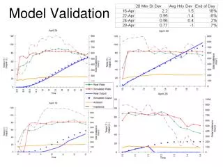
Simulated vs. observed yields dark blue = too low | light blue = good | yellow – red = too high
Data evaluation tutorial • Create maps for single years (rf/ir) • Calculate the average for 1990-2000 (rf/ir) • Weight the yield • Compare with reported yields • Evaluate the results
Data evaluation tutorial • Step 1: • For rain-fed and irrigated results seperately… • Copy the annual output files from the RomaniaHIxRF/IR directory to the Autocalendar directory • Copy RenMax.cmd to the Autocalendar directory • Double-click RenMax.cmd • Use the map generator to create „Multi-years“ output maps for yield from 1990 to 2000
Data evaluation tutorial • Step 2: • For rain-fed and irrigated results separately… • Load the yield maps for 1990-2000 into ArcGIS • From the Spatial Analyst toolbar choose „Cell Statistics…“ • Move all 11 raster files to the select box • Choose as output file name „yd1990_2000“ in the same directory in which the input files are • Remove all raster layers from the data frame
Data evaluation tutorial • Step 3: • Load the harvested areas into ArcGIS • mirca_02_30ir • mirca_02_30rf • mirca_02_30t • Load the rain-fed and irrigated yields into ArcGIS • Rename them to yd1990_2000ir and yd1990_2000rf • Open the Raster calculator and type in ((yd1990_2000ir * mirca_02_30ir) + (yd1990_2000rf * mirca_02_30rf)) / mirca_02_30t • Save the raster layer as yd1990_2000 in folder RomaniaHIx
Data evaluation tutorial • Step 4: • Load the observed yield raster maize_30_f from DVD:\Additional\ObservedYields\SAGE_YIELDS_30_F into ArcGIS • To obtain the goodness of agreement in % type in the raster calculator yd1990_2000 / (maize_30_f * 10)
Data evaluation tutorial • Step 5: • Check out the histogram • Check out the spatial distribution • Compare rain-fed, irrigated, and weighted yields • Look at the results of your seat neighbours
Results HI = 0.3 blue = too low yellow = good red = too high HI = 0.6
Results HI = 0.6 HI = 0.3