Download
1 / 62
720 likes | 1.4k Views
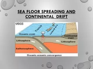
Seafloor Spreading and Continental Drift. Plate Tectonics. A. Plate Tectonics Summary. 1. This is the basic idea that Earths crust is divided into a few large, thick ____________ which are large slabs of the lithosphere.

E N D
Plate Tectonics A. Plate Tectonics Summary 1. This is the basic idea that Earths crust is divided into a few large, thick ____________ which are large slabs of the lithosphere. (a) Plates are part of the______________ move slowly and change in size. (b) Plates may be: (1) entirely ______________ rock (2) both ____________ and _____________ rock (3) entirely ______________ rock plates lithosphere continental continental sea floor sea floor
World Distribution of Earthquakes Earthquakes with focal depths between 0 and 670 km Over a six-year period
Plate boundaries are geologically active with: earthquakes • __________________ • __________________ • __________________ volcanoes young mountain ranges
B. Plate Tectonics combines two preexisting ideas Continental Drift a. ____________________which is the idea that the continents move freely over Earth’s surface, changing their positions relative to one another b. ____________________ which is the hypothesis that sea floor forms a mid-oceanic ridge crests and then moves horizontally away from the ridge towards oceanic trenches. Sea-Floor Spreading
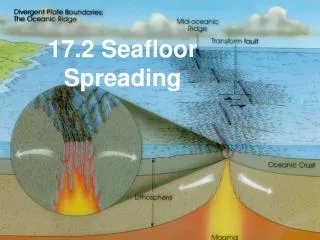
II.Sea Floor Spreading A. This is the hypothesis that: 1. Was originally proposed by Harry Hess, a Princeton University geologist • Sea floor forms at the___________ • The sea floor moves _________________ from the ridge crest toward an oceanic trench where it ___________. • The two sides move in __________ directions Mid-ocean ridge horizontally subducts opposite Convection 5. ________________ in the mantle is the driving force.
B. The Mid-Ocean Ridge • Hot mantle rock rises beneath the ridge as a result of convection 2. This expains high heat flow and basaltic volcanic eruptions. 3. a. ________ at the ridge crest results in cracking open of oceanic crust to form a ____________ b. Shallow focus earthquakes Tension Rift Valley rift valley
c. ______________ Fracture Zones • Major lines of weakness in Earth’s crust. • Cross the mid-ocean ridge at nearly right angles. • Extend for 1000's kilometers across the ocean floor. • The mid-ocean ridge was once continuous across the fracture zones but is now offset.
d. _________________ Transform Faults • Mid-ocean ridges are offset along fracture zones • Transform motion of rocks on either side is not always in opposite directions. • Rocks move in opposite directions only in the section between two segments of ridge crest. • This is the only section that experiences earthquakes instead of along the entire section as would normally be expected.
4. Ocean _________ Trenches • Sea floor moving away from the ridge cools • It becomes denser and ___________, perhaps sinking back into the mantle. • Trenches are explained by the downward plunge of cooler rock and explains negative gravity anomalies. subducts
5. Young Age of the Sea Floor • Less than ______________________ old. • New sea floor continually is formed by basalt eruptions at the _________________. • Basalt is carried horizontally away from the ridge crest where the ____________ rock is found. • Sea floor is continually destroyed by subduction into the mantle at the oceanic trenches 200 million years ridge crests youngest
Deep Ocean Sediments • Deep ocean (pelagic) sediment is thin or absent on the crest of the mid-oceanic ridges. • Sediment becomes thicker away from the ridge.
C. ______________ Data at the Ridges Paleomagnetic • _______ rock formed at the center of the ridge acquires Earth’s magnetic polarity at that time. • Parallel to the ocean ridges there are long strips with alternating magnetic polarity (magnetic anomalies that are symmetrical about the ridge crest). Airborne magnetometer on a U.S. Navy Orion P-3 New
Vine-Matthews Hypothesis • Developed by British geologists Fred Vine and Drummond Matthews • Proposes that the magnetic anomalies match the pattern of magnetic reversals of Earth’s magnetic field as measured in continental rocks.
Correlation of Magnetic Anomalies with Magnetic Reversals Same Age
D. _________ : Models for mid-ocean ridge processes Ophiolites • Pieces of oceanic plate that have been thrusted (obducted) onto the edge of continental plates.
From seafloor drilling and seismic studies Coninental Sequence an assemblage of mafic and ultramafic lavas and hypabyssal rocks found in association with sedimentary rocks They are found in areas that have complex structure
Ophiolites In the French Alps In Cyprus
Alfred Wegener and the Continental Drift Hypothesis • German meteorologist • Credited with hypothesis of continental drift
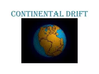
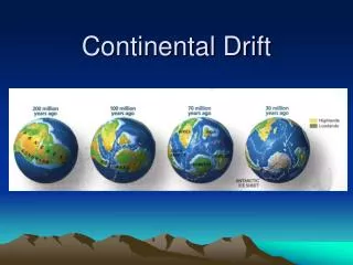
A. Wegener’s Evidence For Continental Drift Pangaea 1. ___________ • Wegener proposed the presence of a giant continent, Pangaea (also spelled Pangea), which literally translated means “all lands.” • When it split apart it separated into two parts with the proto-Atlantic between them (called Tethys Sea). • ____________was the northern supercontinent that contained present-day North America and Eurasia (not including India • _____________________ (also called Gondwana) was the southern supercontinent, composed of all present-day southern hemisphere continents and India. Laurasia Gondwanaland
2. _______ Fit of Continents Jig-Saw Shorelines of continents seem to fit together
3. ____________________ Between Continents Matching Rock Types Continental Shelf (light blue) Broad belts of rocks that Correlate in type and age
4. ____________________ Matching Mountain Ranges When continents are brought together, their mountain ranges form a single continuous range of the same age and style of deformation.
5. _________ Evidence Fossil • Almost identical late Paleozoic fossils in South America, Africa, India, Antarctica, and Australia. • Bones of land reptiles have been found in Antarctic rocks. Antarctica is now completely separate and isolated from other continents.
c. _____________ Glossopteris (1) A Late Paleozoic plant found in rocks on all five continents. (2) When the land areas are joined, similarity can be seen.
d. _______________ Extinct Reptiles • Areas where found reveal narrow, sharply defined habitats extending across: • three continents and • the subcontinents of Madagascar and India. • The shape of the animals ranges can best be explained by assuming that these lands were once united as one landmass.
Mesosaurus • A freshwater carnivorous reptile; cm long • Fossils found in Permian-aged rocks in Brazil and Africa
Lystrosaurus • Early Triassic terrestrial mammal-like reptile • About 1 meter long with two long teeth protruding from the upper jaw • Fossils found in Africa, India, and Antarctica
Cynogathus • Early Triassic terrestrial mammal-like reptile • About 1 meter in length • Fossils found in Brazil and Africa
6. Late Paleozoic _________ Glaciation Glacial evidence shows the Origin of the glaciers in the Atlantic • Distribution of Late Paleozoic continental glacial evidence on the Gondwanaland continents can only be explained by a supercontinent. Boulders in S. America traced to a source in Africa
7. _____________ (Ancient Climates) Paleoclimates a. Inferring the Location of the Poles • If it is assumed that ancient climates had the same geographic distribution as present-day climates, • then the distribution of sedimentary rocks can be used to infer the locations of the ancient poles and the paleoequator.
Glacial Evidence till striations (1) Glacial ____ (soil) and __________ (scratches) on bedrock are found in cold polar climates.
Coral Reefs • Coral reefs are found in tropical regions (as far as 300 north or south of the equator)
Cross-Bedded Sandstones • Indicate the locations of ancient deserts • Latitudes of 30o
(2) ______________ Polar Wandering • Wegener inferred that the ancient poles were in different positions that the present-day poles. • This apparent change in positions of the poles is termed polar wandering.
Explaining Polar Wandering (A) Continents remain stationary and the poles actual change position (B) Poles remain stationary and the continents change position
Paleomagnetic Evidence for Continental Drift • Magnetic dip of magnetite crystals increases towards the North magnetic pole. • Aligned with magnetic lines of force
The Permian North Pole • Permian rocks in N. America point to a pole position in eastern Asia • Rocks in Europe point to a different position • Every continent shows a different Permian pole position
Polar Wandering • Paths of polar wandering have similar shapes • If North America is theoretically pushed back towards Europe, its polar wandering path lies exactly on the path for Europe • Suggests • one north magnetic pole • The continents were joined.
Rodinia – The Late Proterozoic Supercontinent • Assembled between 1.3 and 1.0 billion years ago • Began fragmenting 750 million years ago • Pieces formed another supercontinent, Pannotia, about 650 million years ago
Late Cambrian Paleogeography Russia east of Ural Mts. Asia north of Kazkhsstan And south of Mongolia Most of N. America, Greenland, NW Ireland, & Scotland Africa, Antarctica, Australia, Florida, India, Madagascar, and parts of Middle East & southern Europe Russia west of Ural Mts., major part of N. Europe
Early Paleozoic Era Continental DriftSummary(Cambrian – Silurian) • Six major continents • Four were located near the paleoequator • Laurentia moved northward • Gondwana moved to a south polar location