DAMS
380 likes | 640 Views
DAMS. TERMINOLOGY for DAMS. Dam .........................................................baraj Small dam ...............................................bent veya gölet Reservoir ................................................hazne veya göl alanı

DAMS
E N D
Presentation Transcript
TERMINOLOGY for DAMS • Dam.........................................................baraj • Small dam...............................................bent veya gölet • Reservoir................................................hazne veya göl alanı • Leakage..................................................su kaçağı • Seepage..................................................sızma • Storage...................................................depolama • Coffer dam..............................................batardo • Upstream coffer dam.............................memba batardosu • Downstream coffer dam........................mansap batardosu • Core.........................................................baraj çekirdeği • Filter.........................................................filtre veya geçirgen katman • Diversion tunnel.....................................derivasyon tüneli – çevirme tüneli • Rip-rap.....................................................koruyucu kaya dolgu • Cut-off.....................................................hendek • Toe-drain.................................................topuk drenajı • Right side................................................sağ yan – sağ sahil • Left side..................................................sol yan – sol sahil
River side.....................................nehir içi • Butress.........................................payanda • Foundation...................................temel • Embankment................................sedde • Base-width....................................taban genişliği • Crest..............................................tepe • Cut-off trench...............................saplama hendeği • Expansion joint............................genişleme derzi (dilatasyon) • Spillway........................................dolusavak • Gravity dam..................................ağırlık barajı • Tail water......................................çıkan su • Head water...................................giren su • Arch dam......................................kemer baraj • Abutment......................................yan dayanak • Multiple arch dam........................çok kemerli baraj veya payandalı baraj • Extrados.......................................dış yüzey • Intrados........................................iç yüzey
Parapet...............................................korkulukParapet...............................................korkuluk • Rock fill dam......................................kaya dolgu baraj • Compacted rock fill...........................sıkıştırılmış kaya dolgu • Dumped rock fill................................dökme kaya dolgu • Foot wall.............................................topuk duvarı • Earth dam...........................................toprak baraj • Watertight core..................................geçirimsiz çekirdek • Watertight diaphram.........................geçirimsiz perde • Retaining wall....................................istinat (dayanma) duvarı • Hard ground......................................sağlam zemin • Impervious ground...........................geçirimsiz zemin • Grout curtain.....................................enjeksiyon (harçlama) perdesi • Overburden.......................................sıyrılacak katman • Bedrock.............................................yerli kaya
In Turkey, 536 large dams have been built and being operated. On the other hand, Small Hydraulic Works Department has built 42 small dams. • Here, 50 storage facilities that are not considered as dam due to their low heights (<15m) and low storage capatcities (<2 hm3) have not been taken into account. • By now, construction of 100 dams and hydroelectric powerplants is going on.
Definition • A dam is a structure which prevents the flow of water and accumulates it in a reservoir Karakaya Dam/Diyarbakır Atatürk Dam/Şanlıurfa
Needs for Dam Construction • Drinking and domestic water supply • Flood control • Irrigation • Industrial water supply • Hydroelectric energy production • Retention and control of sediments and Inland navigation, Improvement of water quality, Fish Farming, Recreation facilities
ACCORDING to the SIZE of the DAM • Large (Big) dam • Small dam • International Commision on Large Dams, (ICOLD) assumes a dam as big when its height is bigger than 15m. • If the height of the dam is between 10m and 15m and matches the following criteria, then ICOLD accepts the dam as big: • If the crest length is bigger than 500m • If the reservoir capacity is larger than 1 million m3 • If the flood discharge is more than 2000 m3/s • If there are some difficulties in the construction of foundation
ACCORDING to HEIGHT of DAM • High Dam or Large Dam • If the height of the dam is bigger than 100m • Medium Dam • If the height of the dam is between 50m and 100m • Low Dam or Small Dam • If the height of the dam is lower than 50m
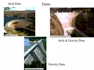
ACCORDING to the STATICAL DESIGN of DAM BODY • Gravity Dams (Sarıyar, Çubuk I, Kemer, Sır II Karacaören II) • Arch Dams (Gökçekaya, Karakaya, Oymapınar, Gezende) • Butress Dams (Elmalı II) • Embankment Dams (Atatürk, Seyhan, Aslantaş) • Composite Dams (Keban)
GRAVITY DAMS • Gravity Dams use their triangular shape and the sheer weight of their rock and concrete structure to hold back the water in the reservoir. Sarıyar Dam – Sakarya River; Height= 90 m Reservoir Capacity= 1.9 billion m3
ARCH DAMS • Arch Damsutilize the strength of an arch to displace the load of water behind it onto the rock walls that it is built into. Karakaya Dam – Fırat River; Height= 173 m Reservoir Capacity= 9,5 billion m3
BUTRESS DAMS • Buttress Dams use multiple reinforced columns to support a dam that has a relatively thin structure. Because of this, these dams often use half as much concrete as gravity dams Elmalı II – Göksu River; Height= 42.5 m Reservoir Capacity= 10 million m3
EMBANKMENT DAMS (Rock Fill or Earth Fill Dams) • They are mostly composed of natural materials such as, clay, sand, gravel etc... • Impervious core is placed in the middle of the embankment body • Generally riprap is used to control erosion Atatürk Dam – Fırat River; Height= 169 m; Reservoir Capacity= 48,7 billion m3
COMPOSITE DAMS • Composite dams are combinations of one or more dam types. Most often a large section of a dam will be either an embankment or gravity dam, with the section responsible for power generation being a buttress or arch. Keban Dam – Fırat River; Height= 163 m; Reservoir Capacity= 31 billion m3 Gravity & Rock Fill
1. RECONNAISSANCE STUDY • Evaluation of the data having at archives of MTA, DSI, EIE, Universities,......etc • Field investigation for limited time (Reconnaissance Study) • Some maps in small scale, for example 1/25.000 or 1/50.000 • Some hydraulic data about • Basin • Precipitation area • Runoff, maximum discharge {Q=R/t (m3/s)} • Modulus of Runoff (R/t/m2 ~ R/t/km2) • Some approach to the reservoir area, dam site and type of dam and height of dam...etc • Photogeological studies • A preliminary report
2. PRELIMINARY STUDIES at the RESERVOIR AREA and DAM SITE • Dam site investigations 1. Location of dam axis 2. Location of diversion tunnel 3. Location of spillway 4. Location of powerhouse...etc • Geological studies • Geophysical surveying • Underground investigations 1. Boreholes 2. Investigation galleries 3. Pitholes • Surveying for materials 1. Field surveying 2. Laboratory tests
Slope stability investigations • Earthquake hazard & risk analysis • Environmental studies • Leakage possibilities from reservoir area • Leakage possibilities from dam site • Erosion, sedimentation & siltation
DETAILED INVESTIGATION at DAM SITE • Topographic surveyings • Geological mappings 1/5000 – 1/1000 or 1/500 • Underground explorations Boreholes, adits....etc • Hydrogeological studies • Slope stability analysis
FACTORS AFFECTING to the DAM TYPE SELECTION • Topography • Geology • Bearing capacity of the underlying soil • Foundation settlements • Permeability of the foundation soil • Material availability • Spillway position • Earthquakes • Safety • Height • Aesthetic view • Qualified labour • Cost
FACTORS AFFECTING to the PLACE of the DAM AXIS • Topography • Geology • Materials • Spillway location availability • Derivation • Sediments in the flowing water • Water quality • Expropriation costs • Earthquake possibility • Downstream water rights
RIVER BASINS in TURKEY Turkey has been separated into 26 main river basins for the hydrological studies.
ENVIRONMENTAL IMPACTS of CONSTRUCTION PHASE of DAMS • River pollution • Erosion • Loss of aesthetic view • Air pollution • Noise pollution • Dust
ENVIRONMENTAL IMPACTS of RESERVOIRS • Loss of land • Habitat Destruction : • The area that is covered by the reservoir is destroyed, killing whatever habitat existed there beforehand. • Loss of archeological and histrorical places • Loss of mineral deposits • Loss of special geological formations • Aesthetic view reduction • Sedimentation • Change in river flow regime and flood effects • Reservoir induced seismicity • Change in climate and plant species
EFFECTS of DAMS to WATER QUALITY • Change in temperature • Turbidity • Dissolved gases in the water • Water discharged from the spillway contains 110-120% saturated nitrogen. This amount may be destructive for fish life. • Eutrophication • It means increase in vegetation. If moss and other plants exist in water, quality of that water gets worse.