Download

1 / 17
0 likes | 8 Views
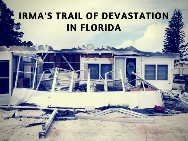
Hurricane Irma, a Category 4 storm, made landfall in the Florida Keys on September 10, 2017, with wind speeds up to 130mph. The Florida Department of Transportation activated emergency measures, including the use of emergency shoulders on highways for evacuation and response efforts. As Irma moved north across Florida, the department implemented various preparedness and response strategies, downgrading Irma from a Category 4 to a Tropical Depression by September 11, 2017.

E N D
Hurricane Irma Rudy Powell Florida Department of Transportation

Satellite Aerial Image (September 10, 2017) Hurricane Irma north of the Keys approaching landfall in mainland Florida as a Category 3 storm. Hurricane Jose following behind Irma as a Category 3 storm. Florida Department of Transportation

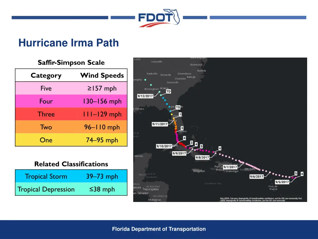
Hurricane Irma Path Saffir-Simpson Scale Category Wind Speeds Five ≥157 mph Four 130–156 mph Three 111–129 mph Two 96–110 mph One 74–95 mph Related Classifications Tropical Storm 39–73 mph Tropical Depression ≤38 mph Florida Department of Transportation

Timeline (Advance Preparations- Evacuation, Fuel, Generators) Tuesday, September 5, 2017 State Emergency Operations Center (SEOC) activated. Prepared emergency generators for deployment and transfer. Mobilized Emergency Roadside Assistance Contractor on Alligator Alley and I-75 in District 5 and I-4 in District 5. Wednesday, September 6, 2017 SEOC Fuel Discussions- shortage of fuel trucks and drivers impacting deliveries. Department Bulk Fuel Sites- anticipating deliveries but all not arriving. Emergency Fuel Resources first ordered. Emergency Shoulder Use- Heads Up! for all corridors sent. Florida Department of Transportation
")
Hurricane Irma Path Saffir-Simpson Scale Category Wind Speeds Five ≥157 mph Four 130–156 mph Three 111–129 mph Two 96–110 mph One 74–95 mph Related Classifications Tropical Storm 39–73 mph Tropical Depression ≤38 mph Florida Department of Transportation

Timeline (Evacuation) Thursday, September 7, 2017 Activated I-75 Emergency Shoulder Use at 8PM. Friday, September 8, 2017 I-75 Emergency Shoulder Use continues. Limits extended south and north. State Office closed. Tropical force winds anticipated to start in south Florida tomorrow. Tropical force winds anticipated to start in north Florida on Sunday. Saturday, September 9, 2017 Deactivated I-75 Emergency Shoulder Use at 11AM. Activated I-4 Emergency Shoulder Use at 3PM. Deactivated I-4 Emergency Shoulder Use at 8PM. Florida Department of Transportation
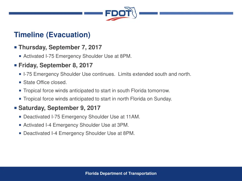
Emergency Shoulder Use Outside shoulder use I-75, Alligator Alley (eastbound and westbound depending on the storm track) Inside shoulder use I-75, Florida’s Turnpike north terminus to Georgia Line (northbound) I-10, Jacksonville to I-75 (westbound) I-4, Tampa to Orlando (eastbound) Florida Department of Transportation
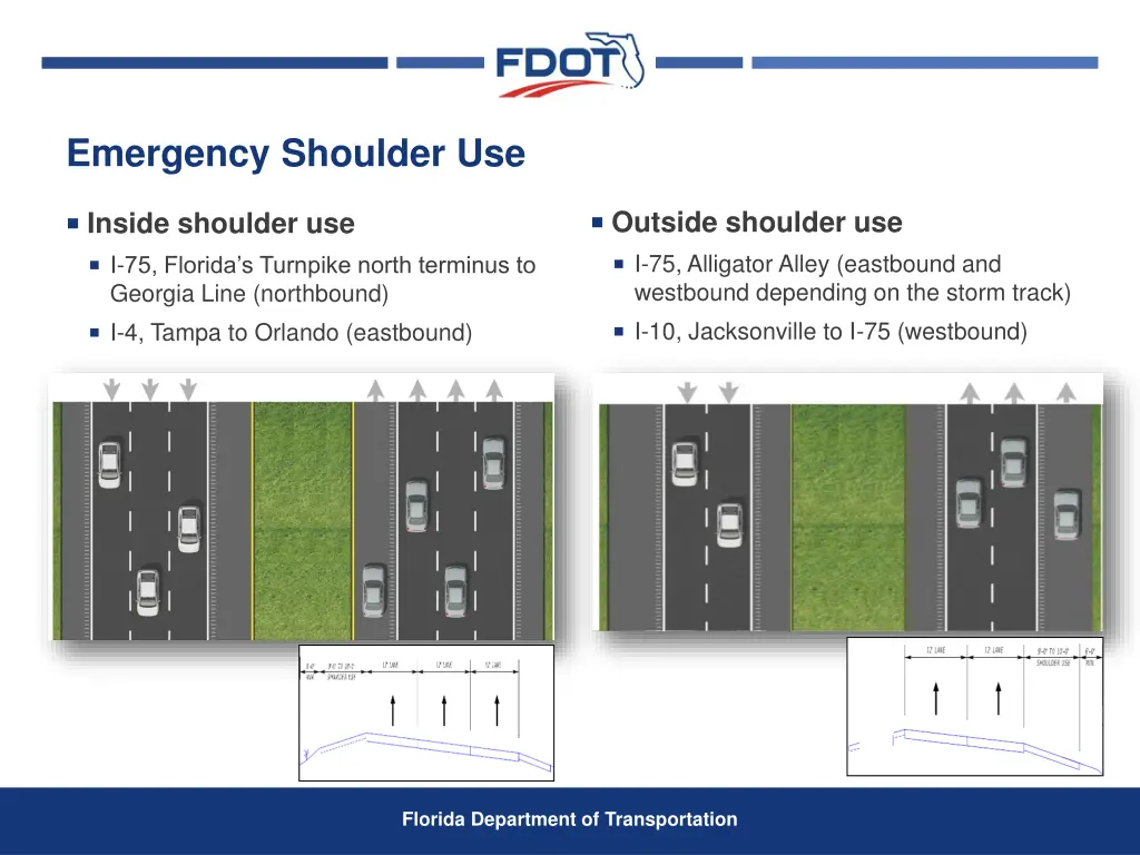
Emergency Shoulder Use Available continuously, one-way limited to daylight hours Same 24-hour capacity as one-way Reverse direction remained available Emergency and incident response Fuel delivery to evacuation areas Resource staging for quick post storm response Easier setup/maintenance/take down Used one-third vendors as many emergency resources Easily adjustable as traffic patterns changed All interchanges retained full egress/ingress Florida Department of Transportation
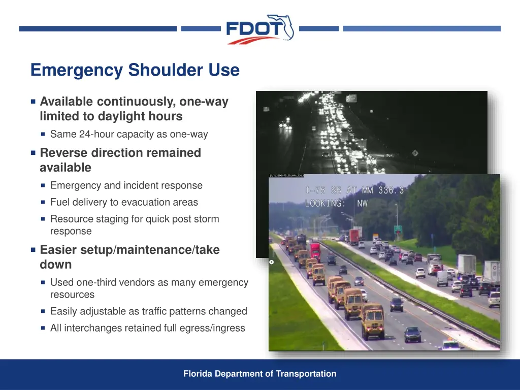
Emergency Shoulder Use Florida Department of Transportation
Hurricane Irma Path Saffir-Simpson Scale Category Wind Speeds Five ≥157 mph Four 130–156 mph Three 111–129 mph Two 96–110 mph One 74–95 mph Related Classifications Tropical Storm 39–73 mph Tropical Depression ≤38 mph Florida Department of Transportation
Hurricane Irma Over Florida Saffir-Simpson Scale Category Wind Speeds Five ≥157 mph Four 130–156 mph Three 111–129 mph Two 96–110 mph One 74–95 mph Related Classifications Tropical Storm 39–73 mph Tropical Depression ≤38 mph Florida Department of Transportation

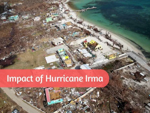
Hurricane Irma Over Florida September 10- 1st Landfall (Cudjoe Key, FL): 130 mph, 929 mb – Category 4 First Category 4 hurricane to make landfall in Florida since Charley (2004) First major hurricane to make landfall in Florida since Wilma (2005) 929 mb pressure is tied for 7th lowest on record for U.S. landfall with Lake Okeechobee Hurricane of 1928 September 10- 2nd Landfall (Marco Island, FL): 115 mph, 940 mb – Category 3 Exact same latitude/longitude as well as Category at landfall as Wilma (2005): 25.9°N, 81.7°W Florida Department of Transportation

September 10, 2017 Upgrades to a Category 4 as it makes landfall in the Florida Keys. Downgrades to a Category 3 as it makes landfall in mainland Florida. Downgrades to a Category 2 as it travels north across Florida. Florida Department of Transportation

September 11, 2017 Downgrades to a Category 1 Hurricane then Tropical Storm as it continues to travel north. Downgrades to Tropical Depression over Georgia. Florida Department of Transportation

Timeline (Initial Emergency Response) Sunday, September 10, 2017 Landfall in south Florida. Cut and toss crews and windshield damage assessment to start at first light tomorrow in south Florida. Monday, September 11, 2017 Storm tracking up the west side of the state passing Tallahassee around 2PM. Cut and toss crews and windshield damage assessment to start at first light tomorrow in north Florida. Response starting in south Florida. Critical routes for National Guard, Utilities, and Special Needs Shelters open. Majority of state roads cleared and open except for flooded areas. US 1 in the Keys open for legal loads for emergency response to MM 37 (Marathon). State Offices closed. Tuesday, September 12, 2017 Response starting in north Florida. Critical routes for National Guard, Utilities, and Special Needs Shelters open. Majority of state roads cleared and open except for flooded areas. US 1 in the Keys open for legal loads for emergency response to Key West. Concerns with re-entry traffic. Florida Department of Transportation
Post-Storm Timeline (Emergency Response) Wednesday, September 13, 2017 Santa Fe River cresting at I-75, US 41, US 27, and SR 47. Monitored throughout the night. Friday, September 15, 2017 First day of returning to “normal” emergency operations. Emergency fuel starting to be released. Saturday, September 16, 2017 Keys opened to returning residents. Friday, September 22, 2017 Concerns and issues with debris contractors. Continued Ongoing Emergency Response Efforts Vegetative debris, C&D debris, leaners and hangers, etc. Emergency fuel in Marathon released October 21. Florida Department of Transportation
Questions? Florida Department of Transportation