Download
1 / 11
130 likes | 395 Views
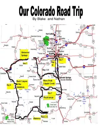
Our Colorado Road Trip. By Blake and Nathan. Day 1 Littleton and Centennial Colorado. Front Range The front range includes to Littleton, where I reside. It is a range of cities that starts in Fort Collins and ends in Pueblo.

E N D
Our Colorado Road Trip By Blake and Nathan
Day 1 Littleton and Centennial Colorado Front Range The front range includes to Littleton, where I reside. It is a range of cities that starts in Fort Collins and ends in Pueblo. http://images.realestate.com/MLS/ns_metrolist/70/31/49/703149_00.jpg Our House • Why we’re going on this trip • To find a plant • To learn more about geography and topography • To visit special places in Colorado Introduction to Geography Geography is the study of the face of the earth , different forms of land such as buttes, mesas, and mountains. It is also the study of animals and plants. Introduction of the characters I, Blake think I am incredibly smart. I like to play jokes on Nathan and I have a pet dog even though I didn’t bring him. Nathan, is my friend. He is an excellent driver although he does not look like he is sixteen. Counties Counties are the sections that Colorado is divided into. Examples: Garfield, Douglas county and Park.
Day 2 Canon City Much of Canon City’s downtown built between 1899 and 1910 remains today. The nearby Arkansas River valley provided plenty of food and natural resources. Since the Royal Gorge was unoccupied, plenty of resources were available for everyone. We drove to the Royal Gorge in Canon City. I still can’t get over when I put flour in Nathan’s pillow to make him look like a ghost. The Royal Gorge is so deep. Across it runs a suspension bridge. Suspension bridges are some of the most strong bridges in the world. I wonder why Nathan acted so scared. Natural resources are things found in nature that can be used, such as trees and water. http://tbn0.google.com/images?q=tbn:shHUh_gDQvHdZM:http://www.destination360.com/north-america/us/colorado/images/s/royal-gorge-bridge.jpg
Day 3 Alamosa http://www.chefdepot.net/graphics27/nonstick_pots_pans.jpg Alamosa features the tallest dunes in North America. The highest elevation in the park is 13,604 ft. We departed at five o’clock this morning. I could not wake up that early. Nathan banged pots and pans together to wake me up. I’d bet he aroused everybody in the hotel too. Before Nathan sat down on his car seat I put a whoopee cushion down. It made a hilarious sound! It took us an hour and thirty minutes before we arrived in Alamosa. We camped in the Di Cristo mountain range that we sand boarded to earlier. We planned to climb the range the next day. http://bp0.blogger.com/_MO5Sqy1DyCw/RwwZn7hD0PI/AAAAAAAAACE/DbSrxOmnSJQ/s320/Great+Sand+Dunes+National+Park+10-6-07+009.jpg The humongous sand dunes. Alamosa was colonized in the mid 1800’s after miners found an abundance of gold. http://farm1.static.flickr.com/238/519789763_1b25d03f8f.jpg?v=0 Another picture of the sand dunes
Day 4 Alamosa Woodlands Zone Numerous animals reside in the Woodlands Life Zone. Some examples are: deer , chipmunks, and snakes. http://www.thecoloradohiker.com/Colorado%20State%20Flower%20Columbine.JPG A Columbine, the Colorado state flower Montane Zone The Montane Forest is the third highest life zone on a mountain. It’s elevation is 5,000 to 8,000 feet high up. Wolves, deer and elk live there. Rocky Mountains and Western Slope The Rocky Mountains are mountains in Colorado which trap most of the precipitation in Colorado, creating the Western Slope. The Continental Divide is included in these mountains. The Western Slope is somewhat wetter because of the melting snow. Many peaches and other fruits and vegetables are grown there. Alpine Tundra Zone The Alpine Tundra is the highest life zone. It reaches over11,500 feet tall. When we finished climbing the range we were in this zone. Pikas and bighorns reside there. We climbed a mountain range which possesses several fourteeners. Fourteeners are mountains that are 1400 feet high and up. There were several mountain passes in the range that we climbed up. We glimpsed at a columbine, the Colorado state flower which are illegal to pick. We mountain biked half of the range and climbed the rest. Afterwards, we took a taxi back to where we parked our car. http://www.naturalsciences.org/education/Yellowstone/2005/images/Bighorn%20Sheep%20ram.jpg A bighorn sheep
Day 5 Alamosa and Black Canyon http://sangres.com/cimages/np/zapatafalls/001f.jpg A pond near Zapata falls, which is a waterfall in Alamosa Native Americans used to reside in Alamosa. The area acquired settlers officially in the mid 1800’s. Hee hee hee! http://www.junglewalk.com/animal-pictures/628/Horse-4837.jpg Nathan’s horse Today we horse backed, looking around for a plant to bring to Mrs. Jones, our teacher from fourth grade. Sometime afterwards when we gave up, we headed towards the wagon wheel gap. Nathan didn’t want to step out of his car, so I departed from my car to look for a plant. I peered into all the nooks and crannies. It only took one hour for me to discover my plant in a small crevice. Nathan felt envy, jealousy and wrath when I brought my plant back. http://radio.weblogs.com/0101170/images/water/johnmartinreservoir.jpg This is a bird’s eye view of the reservoir we rode past A reservoir is a man – made container for water. Sometimes they are used for fishing or boating purposes. A reservoir is created when a dam plugs up the flow of water from a creek, stream or river.
Day 6 Black Canyon http://www.terragalleria.com/images/np-plateau/blca20052.jpeg A picture of the tranquil river at the bottom of Black Canyon. http://www.nps.gov/blca/historyculture/images/278exhibit_2.jpg Black Canyon has known this historical train for 126 years. We drove to Black Canyon in an hour. When we arrived I immediately jumped out of my car and raced out onto the bridge. Nathan followed. When he arrived, I pushed him and gave him quite a scare, although he never fell. He felt extremely scared because I heard him scream. Everybody on the bridge must have heard him. He must be either scared of heights or scared of birds. The Black Canyon is so deep that multiple Statues of Liberty can fit in it. Formed by water erosion, the 2,250 feet deep canyon is nearly impossible to climb. Nicknamed the Scenic Line of the World in 1882; Black Canyon’s railroad had extremely narrow rails. http://www.wildnatureimages.com/images%202/040214-030..jpg A coyote we glimpsed at. Gauge rails (parts of train tracks) used to run through the Black Canyon. They are now underwater.
Day 7 Glenwood Springs We woke up early the day we drove to Glenwood Springs. When we arrived, the time was seven o’clock. Nathan wanted to venture straight to the pool, but I reminded him he had to find a plant for Mrs. Jones. While I looked around and unpacked, Nathan peered everywhere he thought a plant would be. (He only swam for half an hour.) On one of the travel brochures I picked up had some history about Glenwood Springs in it (shown on side.) P.S. Nathan didn’t find his plant yet! A small waterfall near Glenwood Springs The Ute Indians were the first people to reside in the Glenwood Springs area, They were attracted as pulled by magnets by the prime hunting and fishing grounds. They also relished the abundant supply of hot mineral springs. Indians believed that mineral springs were sacred and possessed healing powers. In Glenwood Springs, there are caverns. Named Glenwood Caverns, this system comprises of tunnels, and chambers. Glenwood Springs is near the Contenental Divide.The Continental Divide seperates North America into two watersheds. One is the Western Slope and the other is the Eastern Slope.
Day 8 Pike's Peak and Garden of the Gods Sub Alpine Tundra The Sub Alpine Tundra is a life zone near the top of the mountain. Many animals live here, such as elk, deer, and mountain lions. http://www.planetware.com/i/photo/pikes-peak-colorado-col212.jpg On day 8, we decided to make an unplanned trip to the Garden of the Gods. When we arrived at the visitor center in the Garden of the Gods, we picked up a trail guide. After that, we started off on a hike around the scenic park. After the first mile, we reached a gigantic form of rock that looked like a humpback whale. We also drove to Pike’s Peak. What a sight! 7,400 feet of sheer beauty! Tourists from all around the world come to see Pike’s Peak. Near the top of Pike’s Peak lies the Subalpine Zone (see top of page). When we were in this zone, we glimpsed at some elk strolling through the bushes. When Nathan heard the rustling, he screamed in fright. Scardey cat! The snow on the top of Pike’s Peak hardly ever melts. GARDEN OF THE GODS http://upload.wikimedia.org/wikipedia/commons/5/58/Garden_of_the_Gods_Hogback_Formations.jpg Some rock formations in The Garden of the Gods attract tourists, and some do not.
Day 9 Cripple Creek and San Luis valley http://www.carsonstravels.us/Colorado%20Pictures/cripple%20ck%20brass%20ass%20full.jpg Cripple Creek ,an old mining town possesses an abundance of shops. On the second to last day of our trip, Nathan decidedto make another unexpected trip to a famous mountain park called San Luis Valley. Mountain parks are flat areas completely surrounded by cliffs or mountains. They are mostly located where many rivers run through. When we drove to Cripple Creek we glimpsed a petite and antique sign that read: welcome to Cripple Creek! Cripple Creek possesses a rich history and is one of the many historical landmarks of Colorado. Gold miners traveled from all around the world to visit this stupendous mining location in the 1800’s. Countless families grew to be rich because they found golden nuggets. To discover gold, miners dipped their pans into the water. When they glimpsed gold, they kept it. Cripple Creek is so cool! http://photos.igougo.com/images/p22277-Cripple_Creek_CO-Cliff_House.jpg A historic hotel in cripple creek called the Cliff House.
Day 10 Denver http://www.restoretherockies.org/media/Shrine_Elk.jpg Elk are sometimes called wapiti because that is what Indians called them. I don’t want to drive home! I had fun! Denver had it’s own gold rush in 1850. the pioneers steeled in Colorado for this reason. They brought oxen to pull their wagons and all their supplies. The children usually walked on these long trips. On the last day of our trip we traveled to a lake near home to fish for river trout, the largest type of fish in Colorado. The heaviest one ever caught weighed 44 pounds! When Nathan felt a tug, he fell into the water! After laughing at his hilarious act, I too fell into the water. After splashing each other we felt bored. We decided to venture to the Denver Zoo to observe some Colorado Animals. My favorite was the lynx and Nathan loved the elk. The elk bellowed loudly and sounded like foghorns. The lynx remained quiet and jumped from rock to rock in it’s cage. We wanted some excitement so we mountain biked and observed plants in Colorado. Also, I even glimpsed at a Bighorn, the Colorado State animal. http://www.fishstockphotography.com/images/070907133575_Lake_Trout_LG.jpg Lake trout eat crawdads, small fish and insects.