Download
1 / 3
30 likes | 170 Views
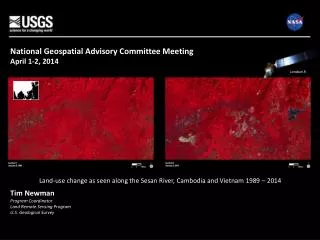
National Geospatial Advisory Committee Meeting April 1-2, 2014. Landsat 8. Land-use c hange as seen along the Sesan River, Cambodia and Vietnam 1989 – 2014 . Tim Newman Program Coordinator Land Remote Sensing Program U.S. Geological Survey. Operational Status. Landsat 8

E N D
National Geospatial Advisory Committee Meeting April 1-2, 2014 Landsat 8 Land-use change as seen along the Sesan River, Cambodia and Vietnam 1989 – 2014 Tim Newman Program Coordinator Land Remote Sensing Program U.S. Geological Survey
Operational Status • Landsat 8 • Collecting approximately 550 new scenes per day; supports 8-day revisit cycle • USGS currently evaluating feasibility of increasing daily collection rate • Improvements: better signal-to-noise, new bands (coastal blue, cirrus, thermal) • Better resolution of snow and ice-covered regions • Detection of water-column constituents • Better cloud screening • More precise temperature measurements • Landsat 7 • Collecting over 400 new scenes per day; about 22% of pixels missing per scene (faulty scan-line corrector) • L7 collection strategy modified to concentrate on continental coverage • Sufficient fuel for a few more years of operation; limited subsystem redundancy • Landsat-based Information Products • Standard orthorectified L1T calibrated radiance Landsat scenes • LandsatLook (full-resolution JPEGs browse/print images) • New TM/ETM+ surface reflectance Climate Data Record (CDR) products currently available • New TM/ETM+ surface temperature CDR products under development; will soon be available for evaluation • New OLI surface reflectance CDR in development • New OLI surface temperature CDR in development • Surface Water Extent, Burned Area Extent Essential Climate Variable (ECV) products available soon for evaluation • Snow-covered area ECVdue late next year NGAC Satellite Update – Slide 2
2014 Guidance for Landsat Advisory Group (LAG) Review and update 2012 paper, “The Value Proposition for Ten Landsat Applications”: • Update and/or add examples • Refine and expand the list of user applications, within and beyond government agencies • Enhance the Landsat value summary USGS to supply recent information from Landsat user case studies, a user-community survey, and a pilot project on remote sensing user requirements