Download
1 / 10
100 likes | 120 Views
Explore the impact of wildfires on air quality and visibility. Discover photos and data from various wildfires across the US.

E N D
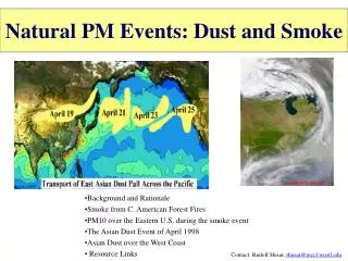
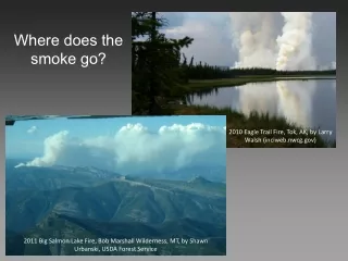
Where does the smoke go? 2010 Eagle Trail Fire, Tok, AK, by Larry Walsh (inciweb.nwcg.gov) 2011 Big Salmon Lake Fire, Bob Marshall Wilderness, MT, by Shawn Urbanski, USDA Forest Service
Nevada 25 km 28 August 2012, Mustang Complex, ID-MT (earthobservatory.nasa.gov) California 26 August 2013, Rim Fire, CA (earthobservatory.nasa.gov)
2012 Mustang Complex, ID-MT, courtesy Sandy Nelson, USFS (inciweb.nwcg.gov) 2012 Mustang Complex, ID-MT (inciweb.nwcg.gov)
Summer 2000, looking west from Stevensville, MT ~5 mg/m3 of PM10
Summer 2000, looking west from Stevensville, MT ~20 mg/m3 of PM10
Summer 2000, looking west from Stevensville, MT ~40 mg/m3 of PM10
Summer 2000, looking west from Stevensville, MT ~60 mg/m3 of PM10
Summer 2000, looking west from Stevensville, MT ~90 mg/m3 of PM10
How far can you see? 7 km 7 km 14 km 11 km 14 km 11 km 16 km 16 km 17 km 17 km ~5 mg/m3 of PM10 ~90 mg/m3 of PM10