Download
1 / 43
440 likes | 459 Views
The Indices of Deprivation 2019 provide relative measures of deprivation for small areas in England, based on seven domains including Income, Employment, Education, Health, Crime, and Living Environment. This report presents the background, methodology, and rankings for York at various levels. York has seen improvements, with lower deprivation rankings compared to previous years. The report also highlights the domains where York excels and areas needing improvement. Produced by the Strategic Intelligence Hub, this report is a valuable resource for understanding and addressing deprivation in York.

E N D
Deprivation in York 2019 Latest Indices of Multiple Deprivation (IMD) Produced by the Strategic Intelligence Hub
Sections 1. IMD Background & Methodology 2. Local authority level deprivation measures 3. LSOA level deprivation measures 4. Range of deprivation within York 5. Ward Level deprivation scores 6. Uses of IMD 7. Sources of further information 8. Appendix - Additional IMD Domain Maps
Section 1 IMD Background & Methodology
IMD Background The Indices of Deprivation 2019 provide a set of relative measures of deprivation for small areasacross England, based on seven domains of deprivation. The domains were combined using the following weights to produce the overall Index of Multiple Deprivation (IMD): • Income Deprivation (22.5%) • Employment Deprivation (22.5%) • Education, Skills and Training Deprivation (13.5%) • Health Deprivation and Disability (13.5%) • Crime (9.3%) • Barriers to Housing and Services (9.3%) • Living Environment Deprivation (9.3%)
IMD Methodology Neighbourhoods in England are given a score and a rank on each domain of deprivation. The national IMD convention is as follows: • A higherscore indicates a greater level of deprivation and a rank of 1 indicates the mostdeprived area Each domain is in turn made up of sub domains e.g. Living Environment is made up of: housing in poor condition, houses without central heating, air quality and road traffic accidents. Crime is made up of violence, burglary, theft, and criminal damage. The data sources used in each indicator were based on data from the most recent time point. For some indicators this is recent (e.g. distance to amenities is 2019 data) but in some cases this is quite old.( e.g. adult skills is based on 2011 census data). For the highest weighted domains (Income and Employment) indicators in the IMD 2019 relate to a 2015/16 time point.
IMD Geography IMD scores / ranks are provided at the level of lower layer super output area (LSOA). These scores are aggregated to provide scores / ranks at the following geographies: • Local Authority Districts • Upper Tier Local Authorities • Clinical Commissioning Groups (CCGs) • Local Enterprise Partnerships (LEPs) Ward level scores are not published but these are calculated at a local level for indicative purposes. This presentation focuses on IMD at local authority, LSOA and ward level for York. (a WYCA presentation is available looking at IMD on a wider footprint – Leeds City Region).
IMD Interpretation • The IMD measures deprivation on a relative rather than an absolute scale i.e. an area ranked 100th is more deprived than one ranked 200th but it does not mean it is twice as deprived. • The level of deprivation in an area does not apply to every person living there (‘ecological fallacy’). • The IMD is designed to measure the presence or absence of deprivation, rather than affluence. • The IMD does not report absolute improvement or worsening of local deprivation over time. A neighbourhood may have reduced deprivation in overall terms, but if other areas nationally have improved by a larger amount, then that neighbourhood’s rank will be shown as having worsened. • Differences between the least deprived areas are less well defined than differences between more deprived areas.
Section 2 Local Authority level deprivation measures
2019 IMD National Ranking for York • The IMD average score for York in 2019 is 11.73. The range in England is 5.85 (least deprived) to 45.04 (most deprived). The score for York in 2015 was 12.2. • York is ranked 140 out of 151 upper tier local authority districts (UTLA) on average IMD score (1 is most deprived) so York is the 12th least deprived UTLA in England.York has risen 5 places in the rankings since 2015when it was the 17th least deprived UTLA. • York is ranked 267 out of 317 lower tier local authority districts on average IMD score (1 is most deprived) so York is the 51st least deprived district in England. York has risen 17 places in the rankings since 2015when it was the 68th least deprived district. Produced by the Strategic Intelligence Hub
2019 IMD Regional Ranking for York • York is the least deprived upper tier local authority out of 15 in the Yorkshire and Humber region based on 2019 average IMD score. This is the same regional ranking as in 2015. • In 2019 York is the second least deprived lower tier local authority out of 21in the Yorkshire and Humber region based on 2019 average IMD score. This is the same regional ranking as in 2015. (Harrogate is the least deprived district in the Yorkshire and Humber Region). Produced by the Strategic Intelligence Hub
2019 IMD Domains for York There are 7 domains which make up the IMD score as well as 2 supplementary indices on income deprivation. The domain on which York ranks the best is Crime (6th least deprived UTLA in England) and the domain on which York ranks the worst is Living Environment (58th least deprived UTLA)…although we are improving on this measure – see next slide. Produced by the Strategic Intelligence Hub
York 2019 IMD Domains v 2015 Compared with 2015, York improved in the national rankings on 4 of the 7 domains, stayed the same on 1 and fell for 2. The domains where York’s ranking fell were Education, Skills & Training and Health & Disability. The York ranking for income deprivation for children and older people both improved. Produced by the Strategic Intelligence Hub
Section 3 LSOA level deprivation measures
Deprivation at LSOA level • Deprivation is measured at the level of lower layer super output area (LSOA). • LSOAs are small areas designed to be of similar population size i.e. an average of roughly 1,500 residents and 650 households. • Measures of proximity (to give a reasonably compact shape) and social homogeneity (to encourage areas of similar social background) are also included. • The 32.844 LSOAs in England are divided into deprivation ‘deciles’ i.e. the most deprived 3,284 LSOAs form the most deprived national decile. • We can see where each of the 120 LSOAs in York fall in relation to these national deciles
National Decile Rank of York LSOAs In 2019 York has 1 LSOA falling in the most deprived 10% (decile) nationally and 41 LSOAs falling in the least deprived decile nationally. About a third of LSOAs in York fall in the least deprived decile nationally York has 6 LSOAs falling in the most deprived 20% (quintile) nationally and 62 LSOAs in the least deprived quintile nationally. About half of LSOAs in York fall in the least deprived quintile nationally Produced by the Strategic Intelligence Hub
Local Deprivation Profile The map illustrates that the majority of LSOAs in York fall in the less deprived national deciles (lighter shading) with a minority of LSOAs falling in the more deprived national deciles (darker shading) Produced by the Strategic Intelligence Hub
Decile rank of York LSOAs 2019 v 2015 In 2015 York had no LSOAs in the most deprived decile nationally. In 2019 there is 1.(York 18B in Westfield which tends to be ranked close to the threshold between 10% and 20% most derpriived in England) In 2015 there were 32 LSOAs in the least deprived quintile nationally. In 2019 there are 41. Produced by the Strategic Intelligence Hub
LSOAs in most deprived quintile 9,588 people in York (4.61% of the population) live in LSOAs which are amongst the 20% most deprived in England. In 2015 the percentage was 3.9%. Produced by the Strategic Intelligence Hub
LSOAs with significant change in Rank 11 LSOAs improved their national rank by 2,500 places or more since 2015 – 5 of these were in Micklegate. 2 LSOAs had a fall in rank by over 2,500 places. The largest changes seem to occur at the less deprived end of the scale. Produced by the Strategic Intelligence Hub
Sample LSOA – York 13G An example of a York LSOA with a significant change in rank is ‘York 13G’ within the Micklegate ward which improved it’s overall IMD rank by 6,410 places and 2 national deciles between 2015 and 2019. (This area covers Toft Green, Tanner Row, Micklegate, North St., Station Rd, West Offices & part of York Station). The main factors behind the improvement are: Crime – improved by 9,571 places and Living Environment – improved by 3,404 places and Employment –improved by 2,433 places . Produced by the Strategic Intelligence Hub
Section 4 Range of deprivation within York
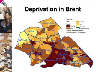
Local Deprivation Range • In this section the range and pattern of deprivation within York is shown by a series of maps. • LSOAs in York are ranked from 1 to 120 on the relevant deprivation measure and then divided into local ‘deprivation deciles’ (without reference to national deprivation deciles). • The most deprived LSOA in York is York 018B (Westfield Ward, Kingsway West area) and least deprived LSOA is York 011D in the Rural West Ward (Poppleton area). This is the 12 least deprived neighbourhood in England. • On the following thematic LSOA maps, the red shaded areas indicate more deprived LSOAs/deciles and the green shaded areas represent the least deprived LSOAs /deciles. Produced by the Strategic Intelligence Hub
Range of York LSOA IMD Scores The map shows the pattern of relative overall deprivation within the City. The more deprived areas (red shading) tend to occur in the central area of the City within the York outer ring road (A1237) with the less deprived areas mainly occurring in the more rural outer wards As an exception to the general rule, there is one area of higher relative deprivation (22nd most deprived LSOA in York) which falls on the outskirts of the City. (Stockton on the Forest). Produced by the Strategic Intelligence Hub
York LSOA Income Deprivation Domain The map shows the pattern of income deprivation in York. The pattern is similar to that of overall deprivation. Maps showing the range of deprivation on all the individual domains are shown in this presentation. The map of the domain on barriers to housing and services is shown on the next slide and the remainder are shown as an appendix Produced by the Strategic Intelligence Hub
York LSOA Barriers to Housing/Services Domain The pattern of deprivation on the barriers to housing and services domain is different to the general pattern with areas of higher deprivation occurring in outer rural areas in the City. This domain relates to distance to amenities (school, GP, post office, doctor, shops), housing affordability (rental and purchase) and overcrowding. Distance to amenities and housing affordability account for the higher deprivation scores on this domain in the more rural parts of York Produced by the Strategic Intelligence Hub
Most Deprived Decile in York The most deprived decile in York (made up of the 12 most deprived LSOAs) is shown in the map below. Can use postcodes of these areas to target services e.g. health checks Produced by the Strategic Intelligence Hub
Most Deprived Decile in York (detailed) Produced by the Strategic Intelligence Hub
Section 5 Ward level deprivation measures
IMD at Electoral Ward Level • The IMD data release does not include a breakdown of scores at ward level. • Ward level deprivation can be estimated using the scores of the LSOAs that fall within the ward boundary area however, this is not an exact science as some LSOAs cross ward boundaries. Ward scores are therefore indicative. • The method used by the CYC Business Intelligence Hub is to take a population weighted average of the scores of all the LSOAs that fall wholly or partly within the ward to create a ward average score. • The 2019 ward values for York are shown in the next slide. Produced by the Strategic Intelligence Hub
York IMD Scores By Ward Westfield is the most deprived ward in York and Copmanthorpe is the least deprived. Compared with 2015 there has been no change in ranking for the 4 most deprived wards (Westfield, Clifton, Guildhall and Heworth) and the 2 least deprived wards (Copmanthorpe and Wheldrake) Some wards have changed ranking however e.g. Mickegate improved by 2 places and Haxby and Wigginton fell by two places.
York IMD Ward Map The York ward IMD map shows that the wards with higher relative overall deprivation (red and pink shaded wards) are mainly located within the York outer ring road. The wards outside the ring road tend to be relatively less deprived.
Individual Ward IMD Maps It is important to note that there can be a wide range of deprivation within the same ward. For example Heworth Ward has the 12th most deprived LSOA in York as well as the 12th least deprived LSOA in York within it’s boundaries. Individual maps can be found on the York Ward Profiles.
Section 6 Uses of IMD
Outcomes by Deprivation If we look at Life Expectancy for males at a City level there is not much change over time. However if we look at LE for each deprivation decile we can see patterns. e.g. a greater spread (inequality) in LE over time in York and a decrease in LE for males in the most deprived decile
Analysis of Outcomes by Deprivation • The broad causes of death which account for the greatest disparity in deaths between males in the most and least deprived quintiles in York are: circulatory diseases (28.1%), cancer (19.3%), external causes (17.7%) and respiratory (14.6%). • The top 6 specific causes of death are: other circulatory, heart disease, accidental poisoning, other cancer, lung cancer and chronic lower respiratory diseases. Source: PHE Segment Tool
Use Analysis to develop an action plan • Deaths from circulatory diseases / heart disease: CYC delivers the NHS Health Check programme which screens 40-74 year olds in York for Cardiovascular Risk Factors. These are delivered from various locations across the City. Uptake of health checks by males in deprived areas is being monitored and locations are being reviewed in relation to the areas of greatest need. • Deaths from lung cancer and chronic lower respiratory diseases: CYC delivers a Smoking Cessation service. Uptake of the service by males in deprived areas is being monitored and locations are being reviewed in relation to the areas of greatest need.. A local Tobacco Alliance has been formed recently in York. • Deaths from accidental poisoning: A review has been undertaken into the deaths of people in drug treatment services (including those dying by accidental poisoning). This involved obtaining detailed information from coroners files. The report is awaiting internal publication.
Section 7 Sources of further information
Further Information on IMD 1. York Open Data – IMD data 2. York Open Data - Ward Maps 3. GOV.UK data release - English indices of deprivation 2019. 4. Local Authority Interactive Dashboard
Section 8 Appendix: Additional IMD Domain Maps