AOSC 200 Lesson 8
AOSC 200 Lesson 8. Precipitation Growth in Warm Clouds. Cloud droplets are typically 10 microns in size. small raindrops are typically 1000 microns (almost one million droplets) How does one go from one to the other?

AOSC 200 Lesson 8
E N D
Presentation Transcript
Precipitation Growth in Warm Clouds • Cloud droplets are typically 10 microns in size. small raindrops are typically 1000 microns (almost one million droplets) • How does one go from one to the other? • Simplest explanation is that the droplet grows by condensation of water vapor on its surface. But this would take several days. • One way for raindrops to form is by a processes known as collision-coalescence. • This process requires lots of droplets - high absolute humidity - seen only in the tropics.
Collision-Coalescence • Warm cloud because process because it only occurs in the tropics. • As the cloud droplet is formed it is pulled down by gravity but then is moved upward by the rising air within the cloud. Hence within a cloud one has droplets moving in all directions and they can collide and form larger droplets by coalescing. • Once a drop grows to a size when the force of gravity exceeds the uplift from the rising air, the drop moves downward through the cloud picking up other droplets as it falls.
Collision-coalescence process Fig. 4-31, p. 114
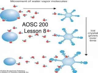
Precipitation Growth in Cold Clouds • Outside of the tropics there are just not enough cloud droplets to form rain drops by the collision-coalescence process. • A Swedish atmospheric physicist, Dr. Bergeron, would vacation in the fall in the mountains. He often took an early morning walk along a path that led through a pine forest and encountered uplift fogs. • He noted that on the days when the temperature was above 0 C, the fog went all the way to the ground, whereas if the temperature fell below -10 C, the fog lay above the tops of the trees.
Why? • He further noted when the temperature fell below -10 C, that the pine needles were covered with ice. • The reason is that the vapor pressure of water above ice is less than the vapor above water.
Attraction of water vapor to ice versus water Fig. 4-33, p. 116
Saturation vapor pressure over ice and over water Fig. 4-35, p. 117
Accretion and Aggregation • It should be noted that the ice crystal growth gives a ‘snow flake’ which eventually will also begin to fall and then rise in the updraft. • These ice crystals then begin to aggregate into larger snowflakes. • The ice crystal can also collide with a supercooled water droplet which instantly freezes - accretion. • As the ice crystals descend at some point the temperature can rise above 0 C, and the crystal melts to form a raindrop.
Process of aggregation Fig. 4-32, p. 115
These picture shows fall-streaks. They consist of ice particles that have fallen out of a cloud and evaporate before they reach the ground. Fig. 4.33
Warm Front Fig. 9.13
FORMS OF PRECIPITATION • RAIN - DROPLETS OF WATER GREATER THAN 0.5 MM IN DIAMETER. WHEN DROPLETS SMALLER THAN 0.5 MM CALLED DRIZZLE. • MUCH RAIN STARTS OUT ALOFT AS ICE CRYSTALS • SNOW - ICE CRYSTALS. IF AIR IS COLD (LOW HUMIDITY), WE GET LIGHT AND FLUFFY SNOW (POWDER). IF AIR IS WARM THAN ABOUT -5 CELSIUS, THEN WE GET WET SNOW (GOOD FOR SNOWBALLS). • SLEET - SMALL PARTICLES OF ICE. RAINDROPS ENCOUNTER FREEZING AIR ON DESCENT. IF FREEZING NOT COMPLETE - FREEZING RAIN. • HAIL - LAYERS OF ICE FORM AS THE HAILSTORM TRAVELS YUP NAND DOWN IN A STRONG CONVECTIVE CLOUD • RIME - FORMED BY FREEZING OF SUPERCOOLED FOG ON OBJECTS.
The effects of airflow over a mountain Fig. 4-42, p. 122
Clouds and Precipitation near Mountains • As air ascends mountain it cools adiabatically, clouds form, and precipitation occurs. • Above this altitude the relative humidity stays at 100% • At the peak of the mountain the absolute humidity is determined by the saturation vapor pressure at -12C. • As the air descends its absolute humidity remains the same as at the peak
Clouds and Precipitation near Mountains • As the air descends it is compressed, so it warms • Hence the saturation vapor pressure will increase, and the relative humidity will decrease • The net effect of the air ascending and descending the mountain is that the air becomes drier and warmer. • On the island of Hawaii, the west side of the coast (westerly winds) has rain forests, the eastern side has deserts.