Download
1 / 10
150 likes | 781 Views
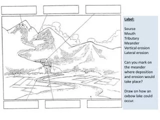
Label: Source Mouth Tributary Meander Vertical erosion Lateral erosion Can you mark on the meander where deposition and erosion would take place? Draw on how an oxbow lake could occur. The lower section of the river!.

E N D
Label: Source Mouth Tributary Meander Vertical erosion Lateral erosion Can you mark on the meander where deposition and erosion would take place? Draw on how an oxbow lake could occur.
The lower section of the river! What physical landforms would you expect to see at the lower part of the river? How can humans be benefited or disadvantaged by living near these landforms? https://www.youtube.com/watch?v=THTasJHgGAE
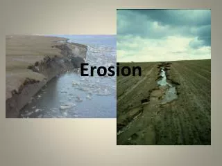
Levees Levees can be natural or manmade. They form on the edge of the river channel. When a river floods the velocity of the river travelling over the flooded floodplain suddenly falls. Because of the fall in velocity (and subsequent reduction in surplus energy) the river immediately deposits its largest load creating embankments that line the river channel. Over time (and after many flood events) these embankments begin to grow in size and become more stable. These are sometimes strengthened by humans or completely made by humans to try and reduce flooding.
Deltas https://www.youtube.com/watch?v=tGHAO15hROs
Deltas are found at the mouth of large rivers - for example, the Mississippi. A delta is formed when the river deposits its material faster than the sea can remove it. There are three main types of delta, named after the shape they create:
Case Study: Formation of Deltas The Ganges Delta https://www.youtube.com/watch?v=xf95cCwSGBI https://www.youtube.com/watch?v=i8R-WpxsK04
Tasks to complete! • Complete the questions on the lower course of a river • Answer questions on the Ganges Delta from the sheet Homework: Complete the questions on Mozambique flooding for your LEDC case study!
Human Impacts on the Hydrological Cycle Whenever you are asked to talk about human impacts on the hydrological cycle, you should try and include as much river geographical terminology as possible. Below are some explanations of human impacts trying to incorporate geographical terminology. Deforestation: When humans cut down trees, there is less interception and therefore less canopy drip and stem flow. This means that more precipitation falls directly onto the surface increasing the number of temporary surface stores and surface run-off. Deforestation tends to increase the risk of flooding because water reaches the ground and rivers quicker, causing the ground to become saturated and rivers to flood. Urbanisation and construction: When houses and roads are built, impermeable surfaces are created, this means there is less infiltration and more surface run-off. However, buildings can also intercept precipitation and humans can build artificial drains which can reduce flooding by redirecting water away from vulnerable areas. Also urban areas (towns and cities) use large amounts of water in showers, toilets, swimming pools, gardens, washing machines and dishwashers. Reforestation and afforestation: This is basically the opposite of deforestation. When humans plant trees, the amount of interception increases. This means that water reaches the ground more slowly because stem flow and canopy drip slow the movement of water downwards. Planting trees can reduce flooding because precipitation reaches the ground and rivers over a longer period giving the ground time to absorb excess water. Irrigation: Irrigation is the watering of the ground. Irrigation is used when there is insufficient precipitation and the ground is too arid to grow crops. Agriculture: Agriculture is the biggest user of water, they use large amounts of water to irrigate crops. Agriculture can therefore reduce the amount of water in rivers and under the ground (groundwater storage - aquifers). Agriculture can also pollute water through its use of fertilisers and pesticides and through animal waste run-off. Fertilisers can cause algae to grow in lakes and rivers which can damage ecosystems (eutrophication - see IGCSE and GCSE Energy, Water and the Environment). Industry: Like agriculture, industry is a big user of water therefore reducing the amount of water in rivers and under the ground. Industry can also be a big polluter as well. Chemicals and metals that are spilt or dumped into rivers can damage ecosystems and make water harmful for humans to drink. Transport: Transport like ferries obviously need ports to be built which can change infiltration rates and surface run-off. They can also cause pollution through oil spills and the noise of propellers can disturb marine life. Dams: Dams create artificial surface stores (reservoirs). They can also reduce the velocity and discharge of rivers by regulating the amount of water released. Because they can regulate the amount of water released they also reduce the risk of flooding.
Exam practice • Explain the change in the shape and characteristics of a river as it travels from source to mouth (5) • Describe and explain the formation of an oxbow lake using diagrams (5) • Describe and explain the formation of delta (5) • For a named place you have studied explain the effects of flooding on an LEDC. (7)