Download

1 / 12
120 likes | 199 Views
Explore the rapid changes and new business models in the orthoimagery industry in the US, including market dynamics, trends, and forecasts presented by Dr. Qassim Abdullah from Woolpert, Inc. Learn about the impact of new sensor technologies, unmanned aerial systems, Google imagery services, and more. Stay informed on the future of orthoimagery production and consumption in the geospatial market.

E N D
Futuristic Look at Orthoimagery Acquisition and Production in the US Presented to: The Main GeoSpatial Sub-Committee For OrthoimageryAcquisition by: Dr. Qassim Abdullah, Woolpert, Inc. September 25, 2014
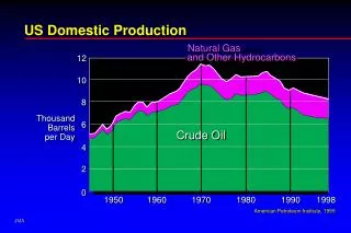
Geospatial Market Forecast Trending up by 9 to 14% Source: ASPRS
Market Dynamics in Rapid Changing Industry Driver: • Rising number of applications that needs orthoimagery. • Increasing number of users as they realize the benefits of using geospatial data, especially orthoimagery, and analytical. technologies for their information needs. • increasing popularity of location-based services.
Market Dynamics in Rapid Changing Industry Change: • New sensor technologies, both in aerial and space systems offer new and improved information capabilities. • Just this year, NOAA authorized the sale of high resolution space (25 cm GSD) imagery to public. • The use of unmanned aerial systems (UAS) is expected to create new opportunities for data providers and end users.
Market Dynamics in Rapid Changing Industry New Business Model: • Crucial to their survival, consolidation (buy up) of small firms into a larger one. • Crucial to their survival, in several cases, satellite and aerial data producers have formed strategic partnerships to enhance each others’ market opportunities. • The emergence of crowdsourcing of data contents model: Hexagon purchasing NWG/Valtus. • The emergence of Google imagery services (aerial and space images).
Market Dynamics in Rapid Changing Industry New Business Model: Crowdsourcing of data contents model: Hexagon • Through Web-based data distribution tools, customers access multiple resolution imagery layers including: • The most current 1-meter ADS100 digital NAIP imagery • High-resolution aerial and satellite imagery • Middle to lower resolution satellite imagery for large area analysis. • They also sale customer's privately owned imagery. • They sale LiDAR data as well. • Subscription based.
Market Dynamics in Rapid Changing Industry New Business Model: Google imagery services (15 cm ortho) They offer flexible ways to consume the data. 1) Users can access imagery from Google data centers and use it online in several ways: •View it in your desktop GIS system via WMS • Include it with your Google Maps v3 JavaScript API web application • Overlay it directly within Google Earth • View it on native mobile applications and mobile websites2) Own it with three years subscription.
Market Dynamics in Rapid Changing Industry Google imagery services (15 cm ortho) • Woolpert is a Google partner and can help users understand how it works • Google 15 cm ortho is delivered with: • accuracy of 1 m • Projected in WGS84 • Jpeg2000 format • Woolpert can deliver enhanced version of the data with: • Accuracy according to ASPRS map accuracy standard • Projected to state plane in NAD83 • User preferred file format • Tiled according to user’s tiling scheme
Market Forecast • Mapping companies will continue to provide their custom services to federal and local government clients. • Crowdsourcing and Google imagery will slowly penetrate state wide projects market. • Increased partnership is expected between services such as Google imagery and mapping companies for value added services. • New space-based imagery with GSD of 30 cm will take over part of the aerial market. • Web servicing of data will grow steeply in the next 10 years.
Market Forecast • As cost goes down and more advancement in oblique viewer software, the use of oblique imagery will grow rapidly in the next few years. • 3-dimensional GIS for urban areas will gain a healthy growth in the next decade or so • Every pixel will have an elevation value tagged to it. People will look use the ortho as 3D and not 2D. • photo-realistic 3D environments
Thank You!Qassim.abdullah@woolpert.commapping_matters@asprs.org