Download
1 / 1
10 likes | 198 Views
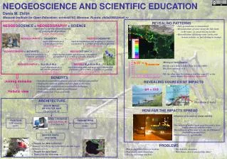
NEOGEOSCIENCE AND SCIENTIFIC EDUCATION Denis M. Zhilin Moscow Institute for Open Education; school#192, Moscow, Russia, zhila2000@mail.ru. REVEALING PATTERNS. NEOGEO SCIENCE = NEOGEOGRAPHY + SCIENCE. Only groundwater is mineralized Mineralization of water along the lake bank

E N D
NEOGEOSCIENCE AND SCIENTIFIC EDUCATION Denis M. Zhilin Moscow Institute for Open Education; school#192, Moscow, Russia, zhila2000@mail.ru REVEALING PATTERNS NEOGEOSCIENCE = NEOGEOGRAPHY + SCIENCE • Only groundwater is mineralized • Mineralization of water along the lake bank • is the same good stirring in lake • Mineralization of swamp water varies even • in near stations bad stirring in swamps NEOGEOGRAPHY+ CHEMISTRY = NEOGEOCHEMISTRY rapid determination of chemical parametersby non-expert users rapid determination and mapping of chemical parameters in a certain geographical position by non-expert users NEOGEOGRAPHY + BOTANICS = NEOGEOBOTANICS rapid determination of botanical parametersby non-expert users rapid determination and mapping of botanical parameters in a certain geographical position by non-expert users Mixing of two streams NEOGEOGRAPHY + BLA-BLA-BLA = NEOGEO BLA-BLA-BLA Mixing zones lasts reaches 50 m (for 2m width) The flows ration is ~1:4 NB: the other year the tributary had the same EC as the main stream. Dependence on weather! rapid determination of Bla-bla-bla parametersby non-expert users rapid determination and mapping of bla-bla-bla parameters in a certain geographical position by non-expert users BENEFITS Joining domains REVEALING SOURCES OF IMPACTS • Introduction and illustration of geoscience theories and patterns • Shifting the students activity outdoors from a classroom. • Linking concealed processes to particular landscapes • Verification of data, patterns and theories. • Preliminary data for professionals rapid and accurate determination of geographical positionby non-expert users pH = 10.8 Holistic view ARCHITECTURE The drain is here SPACE IMAGE OR VECTOR MAP GoogleEarth, $0 HOW FAR THE IMPACTS SPREAD Influence of a road on snow salinity OPEN DATABASE maps.sch192.ru, $0 EGU2011-417 POSITION GPS receiver, $200+ PARAMETERS Sensors or data loggers $200+ The salinity of melted snow near the road is twice higher than of a pipeline water. The influence of the road lasts for 50-150 meters (depending on buildings) The influence is reproducible SHARED MAPS AND DATA • + People for data collection: • Team of 3 if GPS is not integrated with data logger • Team of 1 if it is • + People for data input • + Time (3 hr for this map PROBLEMS • How to implement into curriculum • How to give basic knowledge • How to encourage teachers • The data are uncertain • Who knows, how to proceed the data?