Download
1 / 19
190 likes | 311 Views
This document explores insights from the ARVALIS-Institut du Végétal workshop held on April 26, 2012, in Brussels, focusing on agricultural water pathway management. Key topics include diagnostic tools for assessing and managing water runoff, leaching, and contaminants like pesticides. It outlines methodologies for identifying effective buffer zones, evaluating soil permeability, and assessing landscape factors impacting water flow. The findings emphasize the integration of best management practices (BMPs) tailored to specific water flow paths, promoting sustainable agricultural practices and effective decision-making to mitigate risks.

E N D
Diagnosisrunoff concept Julie Maillet-Mezeray, Benoît Réal Arvalis-Institut du Végétal, France EU Stakeholder Workshop, 26th April 2012, Brussels
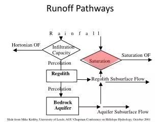
Flow theme • Different water pathways • Datas needed to assess water pathways • Existing audit methodology • Decision support tools to help decisionmaking
Linking water pathway and mitigation measures • Different water flow paths • Possible ways of transfer for potential pollutants • BMP options adapted to type of water flow path Surface Run off Soil surface Permeability disruption Lateralseepage or drainage Leaching
Audit methodology • Diagnosistool to prevent the contamination of water by pesticides atfieldscale • Diagnosistool to locate and size buffer zones Based on french approach (ARVALIS – Institut du végétal + CORPEN + IRSTEA) OptimizedamongProwadispartners, focusing on runoff
- sol argileux sauf sol argileux Audit methodologyatplot scale 1 2 Data collection Identification of water circulation and exposed water Landscape, farm description, types of soil, geology… with the farmer Hydrologycategorisationattheplotscale Method 5 3 Assesseffect of practices Propose adaptedsolutions 4 • Soil management • Cropping practices • Adapting PPP and timing • Vegetative buffer • Wetlands Tillage practices, application periods and PPP Used Duringbothspring and winter time Riskassessment Linking water circulation at plot scalewithin the catchment Developed by ARVALIS-Institut du végétal : : AQUAPLAINE® Based on CORPEN methodology
Data to integrate (step 2) Soil: Texture, permeability of the surface horizon, coarse fragments and shrinkage cracks Soil saturation period Meteorological data + Substrate: Depth, break in permeability and inclination Type of water flow in the soil Direction in which the water is flowing + Landscape: Slope and sinkholes Buffer zones + Effect of practices on water flow Cultivation data Crop, date sown and crop rotation Tillage pan Adjustments: Drainage and drain performance Intensity of water flow
Field observations: concentratedrunoff 2012 Source : G.Le Hénaff - IRSTEA 2012 Source : G.Le Hénaff - IRSTEA
Field observationson buffer zones Source : G.Le Hénaff - IRSTEA
Local conditions, local results Example 2 Example 1 Adapte mitigation measures to pathways Drainage Surface runoff, erosion No risk Catchment of la Nonette Catchment of agripéron
Scale of diagnosis case study 2012 JMM - ARVALIS
Support risk assessment Catchment + field diagnosis observations DETERMINE RISK SITUATION
Decisiontreesparametrization Description of the characteristic of the soil - clayey and loamy soils (>35% clay, <30% sand) - swelling clays >25% - capping soils Rest Description of risk level and bunch of proposals
Integratingcrop practices Soil management No-till Disk tillage Ploughing Vegetation cover Covered limited cover No cover
Differentscales for the diagnosis Area Catchment
Conclusion • Field audit needed • Methodologyavailable • Help tool to support audit: decisiontrees in progress Practical, acceptable, implementable