Download
1 / 16
160 likes | 290 Views
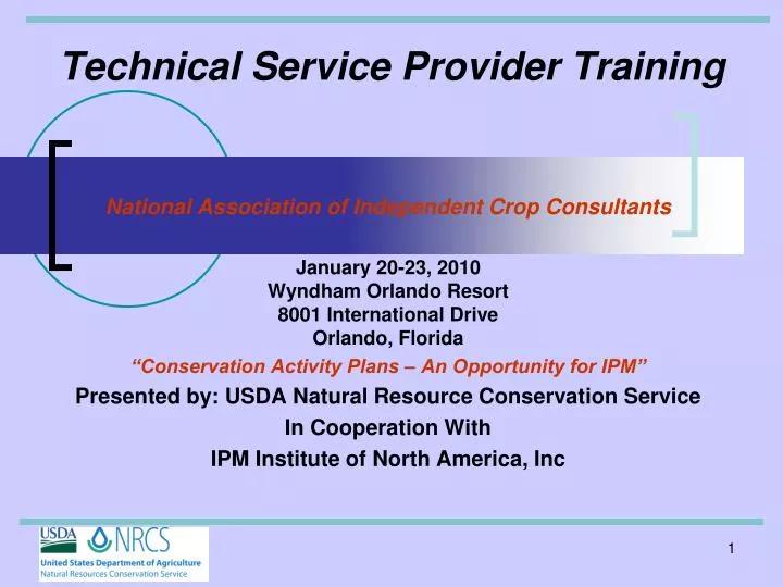
Technical Service Provider Training. National Association of Independent Crop Consultants January 20-23, 2010 Wyndham Orlando Resort 8001 International Drive Orlando, Florida “Conservation Activity Plans – An Opportunity for IPM” Presented by: USDA Natural Resource Conservation Service

E N D
Technical Service Provider Training National Association of Independent Crop Consultants January 20-23, 2010Wyndham Orlando Resort8001 International DriveOrlando, Florida “Conservation Activity Plans – An Opportunity for IPM” Presented by: USDA Natural Resource Conservation Service In Cooperation With IPM Institute of North America, Inc
Technical Service Provider TrainingOverview of RUSLE2 Predicting Soil Erosion using the Revised Universal Soil Loss Equation (RUSLE 2) Tim Pilkowski, State Conservation Agronomist, Maryland, USDA NRCS
What is RUSLE2 ?Revised Universal Soil Loss Equation, Version 2 • NRCS erosion prediction tool used for conservation planning • Estimates soil loss from rill and interrill erosion caused by rainfall and overland flow
TYPES OF EROSION Three types of Soil Erosion • Sheet Erosion • Rill • Gully • RUSLE2 only predicts the soil loss from the first two
Water Erosion Ephemeral/Gully Erosion Rill Erosion Sheet Erosion
RUSLE2 Features Intended to describe changes/scenarios for implementing conservation practices Intended to describe main effects (what is actually happening in the field)
RUSLE2 Features • Measures the Tolerable Soil Loss (T) Expressed as Average Annual Soil Loss in Tons/Acre/Year • Measures the Soil Conditioning Index or SCI • Measures the Soil Tillage Intensity Rating or STIR • Fuel or Energy Use • EQIP Conservation Activity Plans
Sheet & Rill (Rill & Interrill) Erosion Prediction • RUSLE2 • Climate • Soil • Management (Crops and Field Operations) • Length of Slope • Slope Steepness • Supporting Practices
Climate - r factor • Based per county • 10-yr, 24-hr rainfall, in • Annual precipitation, in • Annual-sum of daily values • Daily value=average annual fraction that occurs on a given day • Varies during the year
Soil Erodibility – k factor • Based on type of soil • Based on factors such as • Drainage class (well drained, poorly drained, etc…) • Capability class • Capability subclass • Highly erodible
Tillage Cover-Management – c factor • Crop & Crop Rotation • Tillage • Canopy cover • Crop residue • Application of surface and buried materials • Examples • Live plant material • Plant residue and litter • Applied mulch • Rock
SLOPE LENGTH – l factorSLOPE STEEPNESS – s factor • Field measurement • Measurement of Slope lengths for eroding portions of hillslopes • Measurement of Overland flow slope length • Measurement of Steepness
Supporting Practices – p factor • Contouring • Terrace/Diversion, Grassed waterway • Strip systems
Overland Flow Slope Length Overland flow slope length Eroding portion slope length RUSLE2 ESTIMATES TO HERE Deposition
RUSLE2 website http://fargo.nserl.purdue.edu/rusle2_dataweb/RUSLE2_Index.htm
Tim Pilkowski Maryland State Conservation Agronomist tim.pilkowski@md.usda.gov (443) 482-2962 Questions? For more information contact: