Download
1 / 38
390 likes | 413 Views
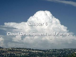
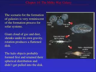
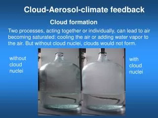
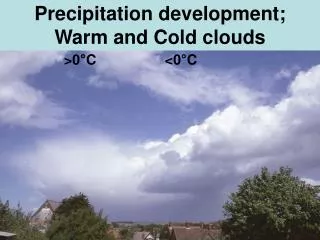
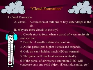
“Cloud Formation”. I. Cloud Formation:. A. Cloud-. A collection of millions of tiny water drops in the air. B. Why are there clouds in the sky?. 1. Clouds start to form when a parcel of warm moist air starts to rise. 2. Parcel-. A small contained area of air.

E N D
“Cloud Formation” I. Cloud Formation: A. Cloud- A collection of millions of tiny water drops in the air. B. Why are there clouds in the sky? 1. Clouds start to form when a parcel of warm moist air starts to rise. 2. Parcel- A small contained area of air. 3. As the parcel gets higher it cools and expands. 4. Cold air can’t hold as much H2O as warm air. 5. The parcel will reach saturation eventually. 6. If the parcel of air reaches saturation, H2O will condense onto any solid object. (Dust, salt, smoke, etc.)
7. If the parcel is allowed to keep on rising millions of H2O drops condense onto this stuff. 8. That is when a cloud is formed. II. Why do clouds form in certain areas? A. Air can be stable or unstable. 1. Stable Air- When a rising parcel of air becomes cooler than the air around it. . A.) High Pressure B.) If the air becomes stable it will sink. C.) If that happens before the air is saturated, a cloud will not form.
2. Unstable Air- When a parcel of air is warmer than the air around it. A.) Low Pressure B.) If the air stays unstable it will continue to rise. C.) If it reaches the saturation level it will form a cloud.
III. Cloud Classification: A. There are three main types of clouds. 1. Cirrus: A.) Thin feather like clouds. B.) High altitude. C.) No precipitation. D.) Can be a clue that a storm is approaching. 2. Cumulus: A.) Thick puffy clouds. B.) Some are cauliflower shaped. C.) Thunderstorms and hail are come in some types.
3. Stratus: A.) Light gray, thin layered clouds. B.) Low altitude. C.) Light precipitation in most types. D.) Fog is an example. B. Cloud Types: 1. There are five words that can be attached to the main cloud types, to give them a more specific name. A.) Cirro- High altitude clouds. B.) Alto- Mid altitude clouds. C.) Strato- Low altitude clouds. D.) Nimbo & Nimbus- Very dark heavy rain clouds.
C. Examples: 1. Cumulonimbus: A.) Cumulus cloud that grew into a very large, dark, heavy rain cloud. B.) This type of cloud is the heaviest rainmaker. C.) Thunderstorms, and tornadoes are common. 2. Nimbostratus: A.) Huge layers of dark., low altitude, rain clouds. B. ) Very long periods of rain can fall from these clouds.
I. High Clouds: 1. Cirrus 2. Cirrostratus 3. Cirrocumulus II. Middle Clouds: 1. Altostratus 2. Altocumulus
III. Low Clouds 1. Stratus 2. Stratocumulus 3. Nimbostratus IV. Clouds with vertical development: 1. Cumulus 2. Cumulonimbus
IV. Precipitation: A. There are 5 types of precipitation. 1. Rain- Drops of H2O falling into areas of above freezing temps.. 2. Snow- H2O that falls as a frozen six sided, flake. 3. Sleet- Forms when snow falls through a warm area of air, melts, then freezes back into an ice pellet. 4. Hail- Warm weather falling lumps of ice. A.) Most commonly found in cumulonimbus clouds. . B.) Water freezes in the upper level of the cloud, into a small ice pellet.
C. ) When it falls it gets caught in the strong up drafts of wind. D.) The up drafts blow the ice pellet back into the freezing temperatures. E.) Another layer of ice forms around it. F.) The process continues until the ice pellets are too heavy for the up drafts. G If the ice pellet does not melt before it hits the ground you will see hail. 5. Freezing rain- Rain drops that are “super cooled”. A.) Salt dissolved in rain lowers the freezing point of H2O. B.) As soon as it touches a solid surface it freezes to it .
“Weather Patterns” I. What causes our weather to change?: A. The movement of different air masses causes weather to change. Large body of air that has the same characteristics as the same area it formed over. 1. Air Mass- B. There are four basic air massed that effect weather in United States. 1. Continental Polar (cP)- Form over cold dry areas. A.) cP air masses bring clear skies, and cold temperatures. B.) Come from Canada.
2. Continental Tropical (cT)- Form over warm dry areas. A.) cT air masses bring clear skies and warm temperatures. B.) Come from Mexico. 3. Maritime Polar (mP)- Form over cold wet areas. A.) mP air masses bring cloudy skies and cold temperatures. B.) Come from the Northern Pacific, or the Northern Atlantic.
4.Maritime Tropical (mT)- Form over warm moist areas. A.) mT air masses bring cloudy skies and warm temperatures. B.) Come form the Gulf of Mexico.
Blues =cold/dry Green =cold/moist Pink =hot/moist Red =hot/dry
C. Why do air masses change weather? 1. These four air mass types can be either stable or unstable. 2. When two different air masses collide weather changes may occur. 3. The boundary between the two air masses is called a front.
II. Fronts: A. What are fronts? 1. Front- The boundary between two different air masses. 2. If air between the boundaries is unstable then clouds will form and a storm may occur. B. There are four types of fronts: 1. Warm Front- Happens when a warm air mass moves into a cold air mass. A.) The warm air will rise over the cold air slowly. B.) If the air is wet, clouds of the stratus and cumulus variety will form.
C.) If the air is dry it will bring nice weather with some high cirrus clouds. D.) On a weather map they look like this: Cold Air Warm Air
2. Cold Front- Happens when a cold air mass moves into a warm air mass. A.) The cold air forces the warm air to rise quickly. B.) Makes the air rise twice as fast as warm fronts. C.) This rapid movement can cuse large rain clouds if the air is wet. . D.) Large cumulus and nimbostratus clouds are common. E.) On a weather map they look like this:. Cold Air Warm Air
3. Occluded Front- Happen when two cold air masses collide and force a warm air mass between them to rise. A.) Very heavy rain will occur if the air mass is wet enough. B.) Cumulonimbus clouds and high winds are common. C.) This is the severe weather front. D.) If air is dry high winds and moderate rain clouds are still common. E.) On a weather map they look like this:
Happens when pressure differences cause a warm front and a cold front to stop moving towards each other. 4. Stationary Front- A.) This type of front may stay in the same area for days. B.) If the air is wet, light precipitation and wind can last for as long as the front is stationary. C.) Nimbostratus clouds are common. D. ) If the air is dry light winds and stratus clouds are common. E.) On a weather map they look like this: Warm Air Cold Air
“Severe Weather” V. Severe Weather Storms: A. Thunderstorms: 1. Thunder Storms occur when warm, moist air moves upward rapidly, cools, condenses and forms cumulonimbus clouds. 2. These clouds are formed from strong updrafts caused by rapidly rising air. 3. As water drops become to heavy, they start to fall toward the ground. 4. The falling water causes strong downdrafts of wind. 5. The rapid updrafts & downdrafts build up electrical charges in the clouds.
B. What causes thunder and lightning? 1. Opposite charges attract. 2. Like charges repel. 3. When a positively charged cloud passes a negatively charged area on the ground, particles from the ground are attracted to the opposite charge in the sky and current flows between them. 4. This is a lightning bolt. 5. Thunder results from the rapid heating of the air around the lightning bolt. 6. Lightning can reach temperatures of 30,000 degrees C.
7. This extreme heat causes the air around lightning to expand rapidly. 8. After the lightning is gone the air cools and contracts. 9. This rapid motion of air particles cause sound waves called thunder.
C. Facts about thunder & lightning: 1. Lightning travels at the speed of light, so it is seen almost instantly. (300,000 km/s, 186,000 m/s) 2. Thunder travels at the speed of sound, so it takes longer to hear it. (1000 ft/s) a.) 1 mile = approx. 5 seconds after lightning you will hear the thunder. • b.) 1 km = approx. 3 seconds after lightning you will hear the thunder. 3. Causes an average of about 200 deaths per year.
“Severe Weather II” VI. Tornadoes: 1. It is a violent funnel shaped wind storm that moves in a narrow path across land. A. What causes tornadoes to form? 1. In very severe thunderstorms, the wind at different heights, blow in different directions, & at different speeds. the difference in wind direction and wind speed. 2. Wind Shear- 3. Strong updrafts tilt the wind shear and produce rotation inside of the thunderstorm.
4. This is when the funnel cloud starts to appear. 5. When it reaches Earth’s surface, they are called tornadoes. B. Facts about tornadoes: 1. Internal winds can reach up to 500 km/hr or 300 mph. 2. Paths of tornadoes are irregular. The path can change at any time. 3. Width of a tornado can be from 100 meters wide to 600 meters wide. (Largest are about ½ -1 mile wide.)
4. Life span is usually less than one hour. (15 minutes on average) 5. Usually occur in the southwest corner of a low pressure system. 6. 3 out of every 4 tornadoes in the world occur in an area called Tornado Alley.
C. Tornado Classification: 1. We use the Fujita Scale to classify tornadoes. • F0 < 72 mph winds • F1 72-112 mph winds • F2 113-157 mph winds • F3 158-206 mph winds • F4 207-260 mph winds • F5 > 260 mph winds 2. Winds can’t be measured. 3. Damage is assessed to find the wind speeds.
VII. Hurricanes: A. What is a Hurricane? 1. A Hurricane is a very intense tropical low- pressure system that has winds of 74 mph (120km/hr) or more. B. What causes the hurricane to form? 1. Wind from the southeast trade winds meet winds form the northeast trade winds. 2. These winds start to spin counterclockwise. 3. A low-pressure system forms in the middle of the spin 4. Air sinks in the center of this system.
5. Outside of the center, warm moist air rises and forms clouds. 6. The center of the hurricane is called the eye of the storm. (high pressure) 7. Outside the eye is an area called the eye wall. (low pressure, most intense area of the storm) 8. When winds reach 74 mph, 120 km/h the storm is called a hurricane. C. Facts about hurricanes: 1. They get their energy from the heat of the water. 2. Hurricanes weaken when they reach land or cold water.
3. Wind speeds can reach 200 mph in the eye wall. 4. Most damage is not done by high winds or rain. 5. Storm Surge causes the most damage. a.) can raise high tide 20-30 feet. b.) Causes extensive flooding. c.) Drowning deaths. d.) Building damage. D. Hurricane Names: 1. Pre 1953 hurricanes were classified only by date. 2. 1953-1979 only female names were used.
3. 1979-present alternating male and female names are used 4. Names are recycled every six years. 5. Names of the strongest storms are retired from use. 6. A name is given to the storm after winds reach 65 mph. 7. A group of people develop a list to use each year. 8. The list is in alphabetical order. The first storm name starts with A.
VIII. Blizzards: A. What is a blizzard? 1. A snow storm that meets all of the following conditions is considered a blizzard. * Wind speeds over 50 mph. * Whiteout condition snow. (1/4 mile visibility.) * Below freezing temperatures. (27 F. or lower.)