Download
1 / 57
630 likes | 1.02k Views
Chapter 16 Earthquakes. What is an Earthquake?. An earthquake is the vibration of Earth produced by the rapid release of energy Energy released radiates in all directions from its source, the focus Epicenter: surface location directly above the focus Energy is in the form of waves

E N D
What is an Earthquake? • An earthquake is the vibration of Earth produced by the rapid release of energy • Energy released radiates in all directions from its source, the focus • Epicenter: surface location directly above the focus • Energy is in the form of waves • Sensitive instruments around the world record the event
What is an Earthquake? • Earthquakes and faults • Earthquakes usually associated with large fractures in Earth’s crust called faults • Most of the motion along faults can be explained by the plate tectonics theory • Earthquake mechanism • Slippage at the weakest point (the focus) occurs • Vibrations (earthquakes) occur as the deformed rock “springs back” to its original shape (elastic rebound)
What is an Earthquake • Foreshocks and Aftershocks • Aftershocks:smaller earthquakes due to adjustments that follow a major earthquake • Foreshocks: small earthquakes that often precede a major earthquake • days or, in some cases • several years
What is an Earthquake? • Elastic rebound • Rocks on both sides of an existing fault are deformed by tectonic forces • Rocks bend and store elastic energy • Frictional resistance holding the rocks together is overcome – rock fractures (breaks) resulting in an earthquake • Earthquakes most often occur along existing faults whenever the frictional forces on the fault surfaces are overcome
Elastic Rebound Stress acting on rocks Stress causes strain, strain builds up Too much stress causes rock failure
Seismic Waves • Body waves • Travel through Earth’s interior • Two types based on mode of travel • Primary (P) waves • Push-pull (compress and expand) motion, change the volume of intervening material • Travel through solids, liquids, and gases • Generally, in any solid material, P waves travel about 1.7 times faster than S waves • Secondary (S) waves • Shake motion at right angles to their direction of travel • Travel only through solids
Seismic Waves • Surface waves • The slowest waves • Cause the largest damage • Love waves • Similar to S wave, but only move side to side • at right angles to their direction of travel • Do not travel through liquid • Rayleigh waves • Similar to ocean waves • Cause ground to move in an elliptical path opposite to the wave direction
Seismology • Seismology: study of earthquake waves • dates back almost 2000 years to the Chinese • allows study of Earth’s interior • Seismographs: instrument that record seismic waves • Records the movement of Earth in relation to a stationary mass on a rotating drum or magnetic tape • horizontal motion • vertical motion • Seismograph record is a seismogram
Seismograph measures vertical ground motion measures horizontal ground motion Seismography animation
Determine distance to epicenter • Intervals between P, S, and surface waves increases as the distance between the focus and the seismic station increases.
Determine distance to epicenter Time – distance curve
Find the location of an epicenter • A minimum of 3 stations needed • They can’t be on the same straight line • Each station will have a seismogram from which the distance from the epicenter is calculated based on the time interval of P and S waves • The common intersect is the location of the epicenter
Measuring Earthquake Size • Two earthquake size measurements • Intensity – a measure of the degree of earthquake shaking at a given locale based on the amount of damage • Magnitude – estimates the amount of energy released at the source of the earthquake • Intensity scales • Magnitude scales
Measuring Earthquake Size • Intensity scales • Modified Mercalli Intensity Scale was developed using California buildings as its standard • The drawback of intensity scales is that destruction may not be a true measure of the earthquakes actual severity
Measuring Earthquake Size • Magnitude scales • Richter scale • Based on the amplitude of the largest seismic wave recorded • Accounts for the decrease in wave amplitude with increased distance • Each unit of Richter magnitude increase corresponds to a tenfold increase in wave amplitude and a 32-fold energy increase
Measuring Earthquake Size • Magnitudes scales • Several “Richter-like” magnitude scales have been developed • Moment magnitude was developed because none of the “Richter-like” magnitude scales adequately estimates the size of very large earthquakes • Derived from the amount of displacement that occurs along a fault
Location and size of EQ in US • Mainly located on the west coast and Aleutian islands – Figure 16.13
San Andreas Fault SystemAn active earthquake zone • Most studied fault system in the world • Displacement occurs along discrete segments 100 to 200 kilometers long • Some portions exhibit slow, gradual displacement known as fault creep • Other segments regularly slip producing small earthquakes • Some segments store elastic energy for hundreds of years before rupturing in great earthquakes, strike slip motion
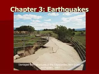
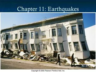
Earthquake Destruction • Amount of structural damage attributable to earthquake vibrations depends on: • Intensity and duration of the vibrations • Nature of the material upon which the structure rests • Design of the structure
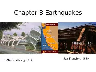
1989 Loma Prieta Mission District San Francisco California 6.9 M, 62 Deaths
Earthquake Destruction • Destruction from seismic vibrations • Ground shaking • Regions within 20 to 50 km of the epicenter will experience about the same intensity of ground shaking • However, destruction varies considerably mainly due to the nature of the ground on which the structures are built • Liquefaction of the ground • Unconsolidated materials saturated with water turn into a mobile fluid • Muddy flow
1989 Loma PrietaSan Francisco, CA Modified Mercalli Intensity Scale
Earthquake Destruction • Destruction from seismic vibrations • Tsunamis, or seismic sea waves • Destructive waves that are often inappropriately called “tidal waves” • Result from vertical displacement along a fault located on the ocean floor • Large undersea landslide triggered by an earthquake
Earthquake Destruction • Tsunamis, or seismic sea waves • In the open ocean height is usually less than 1 m • In shallower coastal waters the water piles up to heights that may exceed 30 m • Can be very destructive • Landslides and ground subsidence
World distribution of EQ • Earthquake belts • About 95 percent of the energy released by earthquakes originates in a few relatively narrow zones that wind around the globe • Major earthquake zones include the Circum-Pacific belt, Mediterranean Sea region to the Himalayan complex, and the oceanic ridge system
Locating Earthquakes Source • Earthquake depths • Earthquakes originate at depths ranging from 5 to nearly 700 kilometers • Earthquake foci arbitrarily classified • shallow (surface to 70 km), • intermediate (between 70 and 300 km), and • deep (over 300 kilometers) • Definite patterns exist • Shallow-focus: oceanic ridge system • Deep-focus: circum-Pacific belt, deep-ocean trenches
Can Earthquakes be Predicted? • Short-range predictions • Goal is to provide a warning of the location and magnitude of a large earthquake within a narrow time frame • Monitoring possible precursors • measuring uplift, • subsidence, and • strain in the rocks • Currently, no reliable method exists for making short-range earthquake predictions
Can Earthquakes be Predicted? • Long-range forecasts • Give the probability of a certain magnitude earthquake occurring on a time scale of 30 to 100 years, or more • Based on the premise that earthquakes are repetitive or cyclical • Using historical records or paleoseismology • Are important because they provide information used to • Develop the Uniform Building Code • Assist in land-use planning