Download

1 / 86
861 likes | 1k Views
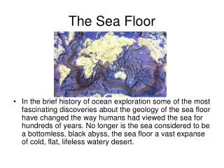
The geological processes of the sea floor play a crucial role in shaping the Earth and influencing marine habitats. They sculpt shorelines, determine water depths, control bottom sediments, and create new islands and underwater mountains. Understanding these processes reveals their significance in marine biodiversity. Oceans, covering 71% of the planet, are vital cultural and climatic regulators. This interconnectedness emphasizes how geological activities impact not only the Earth's structure but also the rich life found in marine ecosystems.

E N D
Geological processes shapethe Earth • How do they influence the Marine Habitat a. Sculpt the shorelines b. Determine water depth, c. Control the bottom sediment d. Create new islands e. Create underwater mountains for organisms to colonize d. Determine the nature of marine habitat.
Earth- Water planet • Ocean covers 71% of the earth • Oceans regulate the climate and atmosphere • Land forms cover 2/3 of the earth
Northern Hemisphere • 61% ocean 2/3 land coverage
Southern Hemisphere • 80% Ocean 1/3 land
Oceans- 4 large Basins • Pacific Ocean – largest and deepest • Atlantic – second largest • Indian – close to the size of the Atlantic • Arctic – smallest and shallowest
Seas • A saline body of water with a connection to the ocean. “sea” syn. For ocean
Land closed Seas • Great Salt Lake • Great Lakes • Caspian Sea • Sea of Galileo
Facts the Great Salt Lake • Largest salt water lake in the world • 4th largest terminal lake in the world. • Size fluctuates due to it shallowness. • Called America’s Dead Sea • Remnant of Lake Bonneville that use to cover much of Utah. Warming Climate created the Present day Salt Lake 16,800 years ago • 10X saltier than the ocean.
Great Lakes Facts • 21% of the freshwater on earth • Connected to the Atlantic ocean through the Saint Lawrence seaway and Great Lakes Water way. • Carved out by retreating Glaciers 10,000 years ago. • Filled with melted water of the glaciers.
Caspian Sea facts • Once part of the Tethy’s Ocean • Landlocked due to plate tectonics • No natural outflow except for evaporation • Volga and Ural Rivers discharge into it. • Levels of the sea controlled by the atmospheric conditions of the North Atlantic ocean. Studies of the global climate changes are invaluable.
Sea of Galilee facts • Located in Northeast Israel in Jordan Rift Valley • This Rift valley is caused by the separation of the African and Arabian Plates. • Out flows the Jordan River and evaporation. • It has salt water springs under the lake, the weight of the freshwater hold it in check on top of them.
World Ocean • All bodies of water are interconnected. • Southern Ocean – continuous body of water around Antarctica
Structure of the Earth • Internal Structures of the earth. Inner Core – solid iron Temperature 4000 C Liquid outer core The movement of the outer core over the inner core is thought to produce the magnetic field
Mantle – layer outside the core, composed of molten material. Crust – outmost layer, differs greatly between ocean and crust. Planet molten. Heat was generated Material settled according to their density.
Density • D = Mass/volume • Mass = grams (g) or milligrams (mg) • Volume = milliliter (ml), liter (L) , cm3 • Densest material flow to the center of the planet. Lightest material cooled to a tin crust (on top) • Atmosphere and ocean began to form. • Density intensive property depend on the composition of a substance, not the size.
Continental and Oceanic Crust • Ocean Crust – basalt • Only 5 km (3miles) thick • Geological young, dark in color, rich in iron and magnesium
Continental Crust - Granite • 20 to 40 km thick ( 12 to 30 miles) • Less Dense than basalt • Present during all geological eras.
Composition of Granite • Silicon dioxide 72.04 % • Aluminium oxide 14.2 % • Potassium oxide 4.12 % • Sodium oxide 3.69% • Calcium Oxide 1.82% • Iron II Oxide 1.68% • Etc.
Why are continents higher than the sea floor? • Continental Crust is of lower density. It rises above. • Mixture – density varies because the composition varies. • Density of a substance tends to decrease with/an increase in temperature. • Rocks – continental rocks can be up to 3.8 billion years old.
Big Bang Theory • Cosmic explosion occurred 13.7 billion years ago. • Dust particles collide and build larger particles such as earth and other planets • Solar system formed 4.5 billion years ago from clouds of dust.
Sir Francis Bacon • Studied the coastlines • Found the coastlines of the continents tend to fit like a jigsaw puzzle.
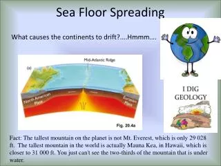
Alfred Wegner • Developed the continental drifting theory. • Continents at one time were joined together as a super continent. Pangea
Plate tectonics • Geological processes caused the continents to drift apart.
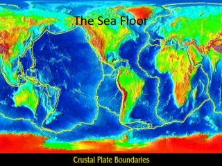
Mid Ocean Ridge • Detected by sonar • Continuous chain of submarine volcanic mountains. • Largest geological feature on earth • Transform faults break up the ridge
Atlantic Ocean • Mid Atlantic Ridge- Ridge forms an inverted Y in the Indian Ocean
Trenches • Deep depressions in the sea floor. • Most are concentrated in the Pacific Ocean • Geological activity concentrated at the ridge • Rocks are very young at the ridge, there is very little sediment.
Magnetic Anomalies • Magnetic bands seen on the ocean floor . • They tend to run parallel to the ridge. • Zone represent alternating and reverse magnetization
Magnetic anomalies cont…… • Indicate that the sea floor was not formed at once, • Indicates that the earth’s magnetic field reverses direction every 700,000 years. • It takes at least 5,000 years to reverse. • The cause of the reversal is the movement of materials in the earth’s molten outer core.
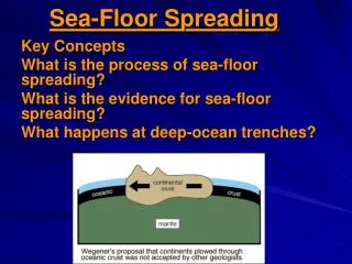
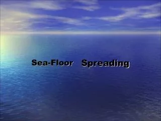
Sea floor Spreading • Located at the top of the ridges. • Ocean crust separated allowing the mantle materials to melt and rise up. • It cools forming new oceanic crust. • Sea floors moves away. • It freezes the magnetic field . The stripe direction preserves the magnetization at the time.
Earth Surface • Compose of granite , the upper part of the mantle. • Lithosphere – Rock Sphere – 100 km thick(60 miles) • Lithosphere Plates – Break off the lithosphere that can contain continental crust, ocean crust or both. • Floats on the asthenosphere.
Mid Ocean Ridge • Forms the edges of the plates. • Plates spread 2 to 18 cm per year. • Lithosphere destoried at the trenches.