Download
1 / 16
160 likes | 269 Views
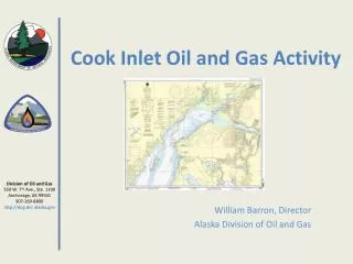
Analyzing Surface Wind Fields Near Lower Cook Inlet And Kodiak Waters Using SAR Eddie Zingone Weather Forecast Office, NOAA/National Weather Service Anchorage Alaska Gary L. Hufford Alaska Region Headquarters, NOAA/National Weather Service

E N D
Analyzing Surface Wind Fields Near Lower Cook Inlet And Kodiak Waters Using SAR Eddie Zingone Weather Forecast Office, NOAA/National Weather Service Anchorage Alaska Gary L. Hufford Alaska Region Headquarters, NOAA/National Weather Service Anchorage Alaska
WhatIs SAR? • SAR = Synthetic Aperture Radar • Onboard a Polar-Orbiting Satellite • SAR is an active sensor that transmits microwave radiation in pulses and records the radiation backscattered in the direction of the sensor. • Measures the return energy off the wavelets caused by the local wind • Algorithm converts the data into an estimated wind speed
Basic Strengths & Deficiencies of SAR • Strengths: • High resolution • Can see through clouds & at night • Deficiencies: • Needs prior knowledge of wind direction • Not available in real time
SAR Data Johns Hopkins University APL http://fermi.jhuapl.edu/sar/stormwatch/web_wind/
References • Bond, N.A., and S.A. Macklin, 1993: Aircraft observations of offshore-directed flow near Wide Bay, Alaska. Mon. Wea. Rev., 121, 150-161. • Fett, R., 1993: The Kamishak Gap winds as depicted in DMSP OLS and SSM/I data. Int. Jour. Rem. Sens., 14, 403-423. • Macklin, S.A., N.A. Bond, and J.P. Walker, 1990: Structure of a low-level jet over lower Cook Inlet, Alaska. Mon. Wea. Rev., 118, 2568-2578. • Mass, C.F., D. Ovens, K. Westrick, and B.A. Colle, 2002: Does increasing horizontal resolution produce more skillful forecasts? Bull. Amer. Meteor. Soc., 83, 407-430 • Monaldo, F.M., 2000: The Alaska SAR demonstration and near real-time synthetic aperture Winds. The John Hopkins University Technical Digest, 21, 75-79. • Monaldo, F.M., D.R. Thompson, R.C. Beal, W.G. Pichel, and P. Clemente-Colon, 2001: Comparison of SAR-derived wind speed with model predictions and ocean buoy Measurements. IEEE Trans. Gesosci. Rem. Sens. 39, 2587-2600. • Pichel, W. and P. Clemente-Colon, 2000: NOAA CoastWatch SAR applications and Demonstration. John Hopkins University Technical Digest, 21, 49-57. • Rosmond, T.E., 1992: The design and testing of the Navy Operational Global Atmospheric Prediction System. Wea. Forecasting., 7, 262-272.