Download
1 / 37
370 likes | 464 Views
CCRM offers expertise in climate change risk assessment, management, adaptation for businesses & governments worldwide. Assess vulnerability, hydrological modeling, and soil erosion associated with climate change.

E N D
Who are ccrm? Climate Change Risk Management (CCRM) is a specialist scientific consultancy originally developed at Oxford University, which offers technical and scientific expertise on a range of issues associated with contemporary and future climate change. Our role is to help businesses, government and others to understand climate change and plan for it.
Our Expertise • Climate change risk assessment, management and adaptation for organisations. • Modelling of future climate scenarios using General Circulation Models (GCMs). We have the expertise to assess and run computer model simulations of the future climate to assess the likely nature of climate change from anywhere in the World. • Assessments of vulnerability of sites to sea level change. • Hydrological modelling and flood risk analysis. • Assessments and monitoring of water supply variations, natural hazard variability and climate change risk. • Modelling of soil erosion and degradation of agricultural land associated with climate change. • Socio-economic impact of climate change, particularly in relation to the tourism industry.
People Dr Stephan Harrison (Director of ccrm) Quaternary Science Professor Ian Foster (Associate) Geomorphology Dr Murray Simpson (Associate) Tourism & Sustainability Professor David Smith (Associate) Sea-Level Change
People (cont) Dr David Stainforth (Associate) Climate Modelling Dr Richard Washington (Associate) Climate Variability and Prediction Dr Matt Wilson (Associate) Flood Hazard and Flood Modelling
Partners Emergency Planning Solutions Fluvio Sustainable Solutions Worldwide
Clients Defra ADAS consulting Lloyd’s of London Environment Agency UK Water plc’s English Nature Danish Environmental Protection Agency Badia Research and Development Programme (Jordan) UK Universities and Private companies World Bank International Atomic Energy Authority European Union
Key Issues Climate change is real. Even the conservative IPCC membership have advised national governments that the world’s scientific community is certain climate change is happening, it is most likely driven by increased greenhouse gas emissions, and is likely to continue in the forseeable future. There is evidence to suggest that predictions concerning ice cap melting and sea level rise are underestimated.
Uncertainty Global Climate Change Models produce variable predictions of change spatially and in time because, e.g. They work on coarse global grids; The climate system is inherently unpredictable (e.g. location of the Jet Stream over the British Isles) which controls much of our weather; The exact quantities of future greenhouse gas emissions are unknown and require top level political agreements to reduce them; We cannot know or model all drivers and complex interactions that will control our weather in the future (e.g. ocean circulation or atmospheric dust concentrations).
Downscaling Global Climate Change Models work at coarse spatial scales. Downscaling to regional scales (RCMs) is required to predict likely changes in climate locally in order for planners and decision makers to undertake detailed risk assessments. RCMs are also inherently uncertain and can only predict a range of possible outcomes. Like GCM’s, they need testing and evaluating against real data to establish which model predictions are most similar to observed reality (more later).
Climate ChangeProblems? The number of interrelated problems is large and many of the implications are poorly understood (e.g.) Territorial losses (Pacific Islands, Insurance claims; Bangladesh, Florida); Coastal and riverine flood risk; Duty of care litigation; Land subsidence; Threats to infrastructure (e.g. nuclear power stations); Ecological Change (terrestrial and aquatic); Slope instability; Erosion and land degradation; Droughts; Water and food security; Political instability.
Example The Association of British Insurers (ABI) suggest that, if present weather trends continue, subsidence claims are set to double in bad years to £1.2bn by 2050. Claims for storm damage are expected to treble to £7.5bn. In a worst-case scenario, inland flood damage from river floods is likely to treble to £4.5bn over the same period, while the bill for damages from coastal flooding will rise from £5bn today to £40bn in the worst years.
Assessing Change Past emphasis has been on temperature records; ? From IPCC
Assessing Change Quantitative measurements (instrumental data) Met. Office weather archive; CEH National river flow archive; CRU @ UEA Lamb daily weather index and central England temperature record; EA databases (water quality, flow, groundwater levels); BGS borehole data; Water plc’s reservoir / borehole data. Historical records Newspaper archives; Fire brigade callout records; Insurance claims; Tax / agricultural returns; OS Maps; etc..... Proxies Ice cores & marine isotopes; Lake sediments (pollen, diatoms etc); Tree rings.
Assessing Change Problems Instrumental records (data accuracy and precision, changes in measurement / recording methods); Historical records (no direct measurement, limited time periods, patchy in space, depends on quality of the observer and recorder [subjective]); Proxy Records (Dating, proxies may respond to temperature and moisture & non-climate controls).
Assessing Change Instrumental Records (e.g. rainfall) often available for over 100 years in many parts of the world. Often daily records are preserved, but analysis of sub-daily intensities generally not available over these timescales. Offers opportunities to analyse change in monthly, seasonal and annual rainfall totals and in assessing the accuracy of climate change predictions.
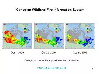
England Rainfall Trends Annual & Seasonal Central London Petworth Park, Sussex (SE) Cornwall (SW)
Assessing Change Key Messages Trends are regionally very variable. Increases in annual rainfall in SE & SW England, stationary in Central London. SW England Annual rainfall has increased by ~ 25% Summers – no change (not consistent with predicted decrease by Met. Office models). Winters – much wetter (consistent with predicted increase by Met. Office models).
Assessing Change Analysis of rainfall data Examples: • Central London, England • Central Karoo, South Africa Based on: • Annual Rainfall trends • Analysis of the number and monthly distribution of extreme events; • Return period analysis of highest daily rainfalls in the first and second half of the 20th centuries.
Assessing Change London > 30 mm Days Frequency of Days > 30 mm by Month Frequency of Days > 30 mm by Year
Assessing Change Frequency of High Magnitude Daily Rainfalls in Central London Daily rainfall with return period of 1 yr has increased from ca. 25mm to ca. 29 mm. Daily rainfall with a return period of 10 yr has increased from ca. 40 mm to ca. 44 mm
Assessing Change Analysis of daily rainfall data In London: Significant increase in the number of days > 30 mm rain; Period of greatest risk has shifted from July to August through October; Daily rainfall across all return periods has increased by ~ 10%
Assessing Change Annual rainfall data SA Karoo, no trend!
Assessing Change Decreasing number of rain Days at constant annual rainfall
Assessing Change Daily Rainfalls exceeding specified thresholds, Middelberg showing significant increase in the number of extreme daily ranfall in 2nd half of record
Assessing Change Return Period Analysis, Middelberg
Assessing Change Analysis of rainfall data In the Karoo: No long term trend in annual rainfall Significant reduction in the number of rain days annually Significant increase in the number of days > 25 mm rain; Daily rainfall across all return periods has increased by ~ 10 mm in the latter half of the 20th Century
Implications While these analyses could be used to test predictions of GCMs and RCMs, the implications of these changes are different for the two case study locations. In London Overflowing storm drains Flooding of roads and basements of buildings Damage to property Disruption to transport Inconvenience to members of the public Loss of revenue for local shops
Implications The analysis raises awareness of when and how often major floods might happen and whether their magnitudes are increasing It will allow Possible redesign of storm drains. Emergency planners to assess when the greatest risk is likely at different times of the year.
Implications In the Karoo; There are significant implications for erosion and land degradation that impact on Agricultural Productivity Sustainability of Water Resources.
Implications South Africa already allocates 98% of its available water resource (a high proportion internationally). It is heavily dependent on water storage reservoirs as rainfall is strongly seasonal (Jan-March) These increases in rainfall intensity increase erosion and sediment transport e.g.
Implications Ganora Catchment: Reconstructed Sediment Yields from Farm Reservoir Sedimentation
Implications Sediment yields have increased dramatically since the mid 20th Century in 4 contrasting catchments in which sediment yield reconstruction has been undertaken and may in part reflect significant changes in the magnitude and frequency of daily rainfall. This has happened despite significant changes in land management that should have reduced sediment yields e.g. No controlled burning of rangelands (natural fires still happen) Abandonment of rain-fed cereal production Significant reductions in stocking density
Implications South Africa’s Van Ryneveldspas dam on the Sunday’s River at Graaf Reinett has a catchment area of 13,382 km2. By 2009 we estimate there will be around 49.1 million m3 of sediment in the reservoir with a remaining storage capacity of only about 29 million m3. South Africa’s Van Ryneveldspas dam on the Sunday’s River at Graaf Reinett has a catchment area of 13,382 km2. By 2009 we estimate there will be around 49.1 million m3 of sediment in the reservoir with a remaining storage capacity of only about 29 million m3.
Implications Compassberg Dam breach. Initial breaching occurred in 2000 following extreme floods and this photo, taken in December 2003, shows the establishment of a new gully that is eroding previously stored sediment.
Implications No evidence to suggest that these breaches are being repaired leading to possible very high rates of sediment delivery to storage reservoirs in the future. A simple and conservative extrapolation from mapping in the region suggests that in a catchment of similar size to that of the Van Ryneveldspas reservoir, there could be as many as 10,000 small farm reservoirs. If each is the size of the Compassberg reservoir containing about 50,000m3 of sediment then there is a potential for around 500 million m3 of sediment storage in the catchment. From our survey area, we also know that 25% have already breached and are not being repaired.
Conclusions If observed changes in the magnitude and frequency of extreme daily rainfall is real it should help us to confirm the direction and magnitude of change to compare with climate change models. We have different issues to contend with in urban and rural areas as illustrated by contrasting studies in urban London and the rural Karoo. New threats to water resources are emerging as a consequence of the research undertaken by members of ccrm and we believe we have much yet to learn about the future risk of climate change in many areas that to date have remained largely unexplored. We need much more research in the future on the magnitude and direction of change in our weather patterns globally so that we can identify the risks and establish viable and timely management strategies.
Conclusions Thank You Please visit our web site at: http://www.ccrm.co.uk/