Download
1 / 25
250 likes | 360 Views
Intercomparison of satellite retrieved aerosol optical depth over ocean.

E N D
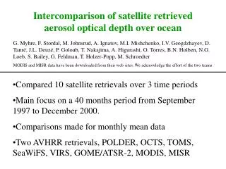
Intercomparison of satellite retrieved aerosol optical depth over ocean G. Myhre, F. Stordal, M. Johnsrud, A. Ignatov, M.I. Mishchenko, I.V. Geogdzhayev, D. Tanré, J.L. Deuzé, P. Goloub, T. Nakajima, A. Higurashi, O. Torres, B.N. Holben, N.G. Loeb, S. Bailey, G. Feldman, T. Holzer-Popp, M. Schroedter MODIS and MISR data have been downloaded from their web sites. We acknowledge the effort of the two teams • Compared 10 satellite retrievals over 3 time periods • Main focus on a 40 months period from September 1997 to December 2000. • Comparisons made for monthly mean data • Two AVHRR retrievals, POLDER, OCTS, TOMS, SeaWiFS, VIRS, GOME/ATSR-2, MODIS, MISR
Where are the uncertainties largest? Myhre et al., JAS, 2003, in press
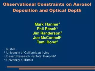
40 months period Averaged AOD (550 nm) over ocean for the period Sep 97-Dec 00. Maximum AOD is 0.72, 1.00, 0.28, and 1.68, respectively for AVHRR-1, AVHRR-2, SeaWiFS, and TOMS.
Spatial correlation between various satellite retrievals for 11 oceanic regions
Comparison with AERONET data • Alot of data available • Generally satellite retrievals compare well with AERONET data • No obvious retrieval perform better/worse compared to the AERONET data
Global land and ocean Global land Global ocean
Modis 2001 annual mean AOD Modelled 1996 annual mean AOD
Summary • Compared 10 satellite retrievals over ocean during 3 time periods • Over ocean the satellite retrievals compare best in coastal regions • Generally at least a factor of two differences • Largest uncertainties over ocean in the southern hemisphere at high latitudes • Some retrievals has upper limits in AOD, which clearly leads to underestimation of AOD for some location and time periods • Compared to AERONET observations the satellite retrievals generally underestimate large AOD, no large difference in size, and region
AOD OVER OCEAN, ZONAL MEAN AVHRR-1(2g), AVHRR-2, TOMS and SeaWiFS for Sep 97-Dec 00, VIRS for Jan-Aug 98, MODIS for Mar-Dec 00.
SCATTER PLOT OF AOD, LAND AND OCEAN STATIONS MISR MODIS