Download
1 / 33
330 likes | 499 Views
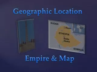
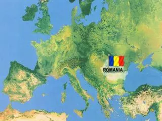
Geographic Location. South east of the Central Europe, north of the Balkan Peninsula, in the Lower Danube basin, bordering the Black Sea. . Geographic Location: . Romania's boundaries.

E N D
Geographic Location South east of the Central Europe, north of the Balkan Peninsula, in the Lower Danube basin, bordering the Black Sea. Geographic Location:
Romania's boundaries - In the east: Ukraine, the Republic of Moldova and the Black Sea;- In the south: Bulgaria;- In the south and south-west: Yugoslavia;- In the west: Hungary;- In the north: Ukraine.
Physical Features Area: Border Length: 238,391 sq. km (12th position in Europe) 3,190.3 km Physical Features: Mountains (31%), hills and plateaus (33%), plains (36%). Hydrograph: The river Danube in the south of the country, length 1,075 km (out of the total 2,850 km from its source to its flowing into the sea).
Hydrograph: The river Danube in the south of the country, length 1,075 km (out of the total 2,850 km from its source to its flowing into the sea).
Other Rivers: Mures, Olt, Prut, Siret, Ialomita, Somes, Arges, Jiu, Buzau, Bistrita etc.
Fauna and flora are very different, being determined in large measure a variety of relief. Of the approximately 3,700 plant species identified in Romania, 23 have been declared natural monuments
Lakes: Approximately 2,300 lakes and over1,150 ponds (2,650 sq. km). The best known are Razelm (415 sq. km), Sinoe (171 sq. km), Brates (21 sq. km), Tasaul (20 sq. km), Techirghiol (12 sq. km) and Snagov (5.8 sq. km).
Climate: Temperate continental, with oceanic influences from the west, Mediterranean from the south-west, excessive continental from the north-east.
Mean annual temperatures: Ranging between 8 degrees in the north and 11 degrees in the south. Average annual rainfall does not exceed 700 m.
Population: 21,698,181 inhabitants (according to 2002 census returns).
Density: 95.7 inhabitants per sq. km (Romanians living outsides the boundaries some 9 million). In Europe, in the Republic of Moldova, some 4 million. In the Hungary, Serbia, Greece, Albania some 2 million. In the United States of America and Canada over 2 million. Others on South America, South Africa and Australia).
Demographic structure: Romanians - 89.57%; Hungarians (plus Szecklers) - 6.6%; other nationalities - 3.9%.
Life expectancy men 66.5 years; women 73.2 years.
Population growth (census years): 8.600.000 (1859), 12.923.600 (1912), 18.052.896 (1930), 15.872.624 (1948), 17.489.450 (1956), 19.103.163 (1966), 21.559.910 (1977).
Capital: Bucharest municipality (1,521 sq. km, divided into six administrative districts, with a population of 2,066,723 lies in the south-eastern part of the country, in the Romanian Plain (altitude 85 m).
It dates back to the 14th century and is recorded in writing for the first time in 1459 as residence of prince Vlad the Impaler. Capital of Wallachia in the 17th-19th centuries and then of Romania since 1862, Bucharest is the most important political, economic, cultural and scientific center of the country. It is crossed by the river Dâmbovita and is bordered by picturesque lakes on the valley of Colentina. Bucharest is a city featuring a rich vegetation, wide parks, which has inspired the name of "garden-city".
Bucharest is a living city with monumental buildings, with outstanding architectural values, big and interesting museums, theatres, opera house, exhibition halls, memorial houses, universities, central public and administrative offices. The Palace of Parliament, for instance, is the second building in the world in point of size, after the Pentagon. The capital is also the largest industrial center of Romania, with numerous factories and plants of all kinds (iron-and-steel, engineering, fine mechanics, tanning yards, food industry).
Administrative division: 41 counties and Bucharest municipality (with a county status), 260 towns (of which 57 municipalities), 2,688 communes (with about 13,000 villages). Bucuresti - The Athenaeum
Main cities:(inhabitants as of 7 January 1992) Constanta (350.581), Iasi (344.425), Timisoara (334.115), Cluj-Napoca (328.602), Galati (326.141), Brasov (323.786), Craiova (303.959). Twenty-five cities have a population of over 100,000, while eight cities exceed 300,000.
Ports: On the Black Sea:Constanţa (can take ships of over 150,000 dwt). Mangalia and Sulina (free port). On the Danube:Turnu Severin, Turnu Magurele, Giurgiu, Oltenita, Cernavoda, Braila, Galati, Tulcea (The last three are both river and sea ports).
Airports: Bucharest-Otopeni, Constanta-Mihail Kogalniceanu, Suceava, Arad, Timisoara (all for international traffic as well), Bacau, Baia Mare, Bucharest-Baneasa, Caransebes, Cluj, Craiova, Deva, Iasi, Oradea, Satu-Mare, Targu Mures, Tulcea.