Download
1 / 47
570 likes | 1.38k Views
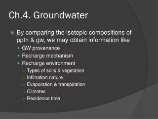
WFM 5103 Hydrogeology and Groundwater Lectures 3-4. WFM 5103 Hydrogeology and Groundwater . Subsurface environment Water bearing properties of rocks and soils Principles of groundwater movement Recharge Groundwater withdrawal Groundwater Quality Groundwater in Coastal zones

E N D
WFM 5103 Hydrogeology and Groundwater Lectures 3-4
WFM 5103 Hydrogeology and Groundwater Subsurface environment Water bearing properties of rocks and soils Principles of groundwater movement Recharge Groundwater withdrawal Groundwater Quality Groundwater in Coastal zones Hydrogeological mapping Groundwater management Conjunctive use Groundwater Models Groundwater development in Bangladesh
RECAP piezometer Observation well
Aquifer properties/parameters Water transmitting parameter Permeability or Hydraulic Conductivity Mean pore velocity:
Pores, Porosity and Permeability Pores: The spaces between particles within geological material (rock or sediment) occupied by water and/or air. Porosity:is defined as the ratio of the volume of voids to the volume of aquifer material. It refers to the degree to which the aquifer material possesses pores or cavities which contain air or water. Permeability:The capacity of a porous rock, sediment, or soil to transmit ground water. It is a measure of the inter-connectedness of a material's pore spaces and the relative ease of fluid flow under unequal pressure.
Perched Aquifers An aquifer in which a ground water body is separated from the main ground water below it by an impermeable layer (which is relatively small laterally) and an unsaturated zone. Water moving downward through the unsaturated zone will be intercepted and accumulate on top of the lens before it moves laterally to the edge of the lens and seeps downward to the regional water table or forms a spring on the side of a hillslope.
Specific retention -Water that is retained as a film on rock surfaces and in very small openings. The physical forces that control specific retention are the same forces involved in the thickness and moisture content of capillary fringe Specific yield -Water that will drain under the influence of gravity
Groundwater exploration Geologic methods Groundwater withdrawal Groundwater exploration Geologic methods
Relation between K and grain-size distribution Water transmitting Parameter….contd. (a) General relationship (b) Empirical formulas (i) Hazen A = 1.0 for K in [cm/sec] and d10 in [mm] (ii) Krumbein and Monk dg= geometric mean grain diameter [mm]; k in [mm]; (i) Kozeny-Carman
Water transmitting Parameter….contd.
Transmissivity Water transmitting Parameter….contd. T = Kb
Storage parameter Unconfined aquifer Specific yield -Water that will drain under the influence of gravity Confined aquifer Storage coefficient/storativity -Water that is released or taken into storage per unit surface area of aquifer per unit change in head = bulk modulus of compression of matrix = bulk modulus of compression of water
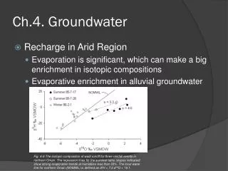
Head gradient From surrounding aquifer to well Convergent flow into the well Decline in WL in well Pumping Cone of Depression
Cone of Depression • Unconfined aquifer • Cone of depression expands very slowly (drainage through gravity) • Increased drawdown in wells and in aquifer (dewatering of aquifer) • Confined aquifer • Cone of depression expands very rapidly (why??) • No dewatering takes place Mutual interference of expanding cones around adjacent wells occurs more rapidly in confined aquifers
1. 1 Exploration of groundwater Objective: to locate aquifers capable of yielding water of suitable quality, in economic quantities, for drinking, irrigation, agricultural and industrial purposes, by employing, as required, geological, geophysical, drilling and other techniques. Assessments of ground water resources range in scope and complexity from simple, qualitative, and relatively inexpensive approaches to rigorous, quantitative, and costly assessments. Tradeoffs must be carefully considered among the competing influences of the cost of an assessment, the scientific defensibility, and the amount of acceptable uncertainty in meeting the objectives of the water-resource decision maker.
Groundwater exploration Exploration of Groundwater 1.1.1 Surface exploration - “non-invasive" ways to map the subsurface. -less costly than subsurface investigations 1. Geologic methods 2. Remote Sensing 3. Surface Geophysical Methods (a) Electric Resistivity Method (b) Seismic Refraction Method (c) Seismic Reflection Method (d) Gravimetric Method (e) Magnetic Method (f) Electromagnetic Method (g) Ground Penetrating Radar and others
Groundwater exploration Exploration of Groundwater 1.1.2 Subsurface exploration 1. Test drilling geologic log drilling time log Water level measurement 2. Geophysical logging/borehole geophysics Resistivity logging Spontaneous potential logging Radiation logging Temperature logging Caliper Logging Fluid Conductivity logging Fluid velocity logging 3. Tracer tests and others
Groundwater exploration Exploration of Groundwater 1.1.1 Surface exploration - “non-invasive" ways to map the subsurface. -less costly than subsurface investigations 1. Geologic methods 2. Remote Sensing 3. Surface Geophysical Methods (a) Electric Resistivity Method (b) Seismic Refraction Method (c) Seismic Reflection Method (d) Gravimetric Method (e) Magnetic Method (f) Electromagnetic Method (g) Ground Penetrating Radar and others 1.1.2 Subsurface exploration 1. Test drilling geologic log drilling time log Water level measurement 2. Geophysical logging/borehole geophysics Resistivity logging Spontaneous potential logging Radiation logging Temperature logging Caliper Logging Fluid Conductivity logging Fluid velocity logging 3. Tracer tests and others
Groundwater exploration Geologic methods Groundwater withdrawal Groundwater exploration Geologic methods • 1.1.1.1 Geologic Methods • an important first step in any groundwater investigation • involves collection, analysis and hydrogeologic interpretation of existing geologic data/maps, topographic maps, aerial photographs and other pertinent records. • should be supplemented, when possible, by geologic field reconnaissance and by evaluation of available hydrologic data on stream flow and springs, well yields, groundwater recharge and discharge, groundwater levels and quality. • - nature and thickness of overlying beds as well as the dip of water bearing formations will enable estimates of drilling depths to be made.
Groundwater exploration Geologic methods Groundwater withdrawal Groundwater exploration Geologic methods Relationship between geology and groundwater The type of rock formation will suggest the magnitude of water yield to be expected. it is the perviousness or permeability and not porosity which is significant in water yielding capacity of rocks. Igneous rocks have a porosity of 1% and may yield all water while some clays have a pososity as high as 50% but are practically impervious. Porosity = f (grainsize, shape, grading, sorting, amount and distribution of cementing materials) Permeability = f (interconnectedness, fissures, joints, bedding planes, faults, shear zones and cleavages, vesicles )
Groundwater exploration Geologic methods alluvial aquifers :90% of all developed Aquifers are alluvial aquifers, consisting of unconsolidated alluvial deposits, chiefly gravels and sands. Limestone aquifer varies in density, porosity and permeability depending on degree of consolidation and development of permeable zones after deposition. Original rock materials offer important aquifers. Volcanic rock can form highly permeable aquifers. Basalts form a good source of water; easily susceptible to weathering. Sandstones are cemented forms of sands and gravels; yields are reduced by the cements. Some may form good aquifers depending on shape and arrangement of constituent particles and cementation and compaction. Igneous and metamorphic rocks, in solid state, are relatively impermeable and hence serve as poor aquifers. Under weathered conditions, however, the presence of joints, fractures, cleavages and faults form good water bearing zones, and small wells may be developed in these zones for domestic water supply. Relationship between geology and groundwater
Selection of site for a well Factors to be considered are: (i) Topography: Valley regions are more favorable than the slopes and the top of the hillocks. (ii) Climate(annual rainfall, sunlight intensity, max. temperature, humidity): heavy to moderate rainfall -- more deep percolation – good aquifer. Intense summer weather -- evaporates and depletes GW through direct evaporation from shallow depths and evapotranspiration through plants.
Selection of site for a well Groundwater exploration Geologic methods (iii) Vegetation: can flourish where GW is available at shallow depths. Phreatophytes, plants that draw the required water directly from the zone of saturation indicate large storage of groundwater at shallow
Selection of site for a well Groundwater exploration Geologic methods (iii) Vegetation: can flourish where GW is available at shallow depths. Phreatophytes, plants that draw the required water directly from the zone of saturation indicate large storage of groundwater at shallow depths. Xerophytes, plants that exist under arid conditions by absorbing the soil moisture (intermediate or vadose water), indicate the scarcity of groundwater at shallow depths.
Selection of site for a well Groundwater exploration Geologic methods (iii) Vegetation: can flourish where GW is available at shallow depths. Phreatophytes, plants that draw the required water directly from the zone of saturation indicate large storage of groundwater at shallow depths. Xerophytes, plants that exist under arid conditions by absorbing the soil moisture (intermediate or vadose water), indicate the scarcity of groundwater at shallow depths. Halophytes, plants with a high tolerance of soluble salts, and white efflorescence of salt at ground surface indicate the presence of shallow brackish or saline groundwater.
Selection of site for a well Groundwater exploration Geologic methods (iv) Geology of the area:thick soil or alluvium cover, highly weathered, fractured, jointed or sheared and porous rocks indicate good storage of groundwater, whereas massive igneous and metamorphic rocks or impermeable shales indicate paucity of groundwater. (v) Porosity, permeability: highly porous, permeable zones of dense rocks encourage storage of groundwater. Massive rocks do not permit the water to sink. (vi) Joints and faults in rocks: Wells sunk into rocks with interconnected joints, fractures, fissures and cracks yield copious supply of water. (vii) Proximity of rivers: Streams and rivers serve as sources of recharge and water is stored in the pervious layers.
Groundwater exploration Remote sensing Source A physical quantity (screen) (light/radiation) Sensor Processor signal (records data and interprets information) (eyes) 1.1.1.2 Remote sensing
Groundwater exploration Remote sensing • Remote sensing • an increasingly valuable tool for understanding GW conditions. • information on an object on the earth is acquired by remote registration/ sensing from aircraft or satellite at various wavelengths of the electromagnetic energy reflected and emitted. • difference in reflectance properties of objects produce varying signatures on the photos or images, which can be interpreted for a variety of purposes of which application of hydrogeology is one. • stereoscopic airphotos (color, black and white, infrared), oblique air photos and high resolution satellite imageries taken from GMS, APT, NOAA, AVHRR, SPOT and Landsat, ERS-SAR, RADARSAT, open up new possibilities for the assessment of groundwater resources. • - observable patterns, colors, and relief makes it possible to distinguish differences in geology, soils, soil moisture, vegetation and land-use (hence areas of groundwater recharge and discharge).
Groundwater exploration Remote sensing • RS applications • forest cover mapping and monitoring; • land use and land cover mapping; • mapping of water resources; • Others: agriculture; fisheries; coastal zone; marine environment.
Identify data needs Land cover
Groundwater exploration Remote sensing Advantages of remote sensing technique in general: - speed of operation - survey of inaccessible areas - possibility of repetitive coverage of changing landform, land use, vegetal cover, water spread in reservoirs, soil salinity, water logged areas, etc. - permits mapping and preliminary evaluation at lesser cost. “The remote sensing technique is only an additional tool in the quest of groundwater and not a substitute for other methods. For a meaningful interpretation, there should be adequate ground check in the field”.
Groundwater withdrawal Groundwater exploration Surface geophysical methods • 1.1.1.3. Surface Geophysical • Methods • - scientific measurement of physical properties and parameters of the earth’s subsurface formations and contained fluids by instruments located on the surface for investigation of mineral deposits or geologic structure. • provide only indirect indication of groundwater • -success depends on how best the physical parameters are interpreted in terms of hydrogeological language. • - Accurate interpretation requires supplemental data from subsurface investigations to substantiate surface findings.
Groundwater exploration Surface geophysical methods Electric resistivity Groundwater withdrawal Groundwater exploration Surface geophysical methods 1.1.1.3 (a) Electric Resistivity Method ♦Electrical resistivity is the resistance of a volume of material to the flow of electrical current. ♦current is introduced into the ground through a pair of current electrodes ♦resulting potential difference is measured between another pair of potential electrodes ♦Apparent resistivity is then calculated as: V is the measured Potential difference (in Volts) and I is the current introduced (in Amperes).
Groundwater exploration Surface geophysical methods Electric resistivity Wenner arrangement Schlumber configuration 1.1.1.3 (a) Electric Resistivity Method
Groundwater exploration Surface geophysical methods Electric resistivity The measured potential difference is a weighted value over a subsurface region controlled by the shape of the region, and yields an apparent resistivity over an unspecified depth. • Vertical electrical Sounding (VES) Changing the spacing of electrodes changes the depth of penetration of the current. So it is possible to obtain field curve of apparent resistivity vs depth. For a single homogeneous, isotropic layer of infinite thickness, resistivity curve will be a straight line. True/actual resistivity - if formation is homogeneous and isotropic. Apparent resistivity if formation is anisotropic consisting of two or more layers of different materials.