Download
1 / 41
490 likes | 1.38k Views
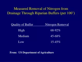
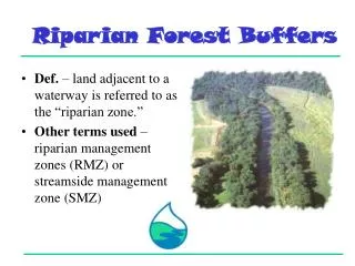
Riparian Forest Buffers. Def. – land adjacent to a waterway is referred to as the “riparian zone.” Other terms used – riparian management zones (RMZ) or streamside management zone (SMZ). Benefits. Control surface runoff and shallow ground water Nutrients Sediment Shade streams

E N D
Riparian Forest Buffers • Def. – land adjacent to a waterway is referred to as the “riparian zone.” • Other terms used – riparian management zones (RMZ) or streamside management zone (SMZ)
Benefits • Control surface runoff and shallow ground water • Nutrients • Sediment • Shade streams • Ameliorate effects of some pesticides • Provide dissolved and particulate organic food for aquatic and terrestrial systems Sheet erosion on crop land
Shallow Groundwater • Frequently occurs in riparian areas • Saturated condition which occur near or within the root zone of trees and other woody vegetation and at relatively shallow depths where bacteria, oxygen, and soil contribute to denitrification
Nonpoint Source Pollution • NPS pollution is caused by rainfall or snowmelt moving over and through the ground. • As the runoff moves, it picks up and carries away natural and human-made pollutants, finally depositing them into lakes, rivers, wetlands, coastal waters, and even our underground sources of drinking water.
Nonpoint Source Pollution (NPS) • NPS Pollutants include: • Excess fertilizers, herbicides, and insecticides from agricultural lands and residential areas; • Oil, grease, and toxic chemicals from urban runoff and energy production; • Sediment from improperly managed construction sites, crop and forest lands, and eroding stream banks; • Salt from irrigation practices and acid drainage from abandoned mines; • Bacteria and nutrients from livestock, pet wastes, and faulty septic systems; • Atmospheric deposition and hydromodification.
NPS: Hydromodification • Hydrography: • Configuration of an underwater surface including its relief, bottom materials, coastal structures, etc. • Description and study of seas, lakes, rivers, and other waters.
NPS: Hydromodification During Before • Hydrologic modification: • The alteration of the natural circulation or distribution of water by the placement of structures or other activities Bear Creek, Blackfoot River, Montana After
NPS: Hydromodification • Alteration of the hydrologic characteristics of coastal and noncoastal waters, which in turn could cause degradation of water resources Undersized and perched culvert on McCabe Creek before restoration Open bottom box culvert on McCabe Creek after restoration
Example of Hydromodification • Streambed scouring and bank erosion resulting from storm surges within urbanized watersheds
NPS: Sediment • Total suspended solids (TSS), i.e., sediment is major NPS pollution of concern
NPS: Phosphorus • Major nutrient leading to water pollution • Leads to low dissolved oxygen from excessive plant growth • Binds to soil particles
NPS: Nitrogen • Water soluble • Some converted to gaseous forms by microbial action • Enters surface and goundwater
Underlying Principles of Buffers • Vegetation and soil filters sediments • Vegetation takes up nutrients which can be removed from portion of site by harvesting timber and forage. Clearfield Creek in PA, stable structure but polluted by mine drainage
Streamside Forest as Sediment Filter • Sediment settles as speed of surface flow reduced by forest floor • Sediment is filtered out as sediment loaded water percolates into porous forest floor
Riparian Forest Buffer • Forest dominated landscapes • Leave continuous unharvested forest along waterways • Agriculture dominated landscapes • Create 3 zone buffer along waterways
Riparian Forest Buffer • Where to use • Adjacent to permanent or intermittent streams occurring at lower edge of upslope crop land, grassland or pasture, or harvested forest • Margin of lake or ponds
Riparian Forest Buffer • Where to use • Margin of intermittent or permanently flooded, environmentally sensitive open water wetlands • On karst formations at margins of sinkholes and other groundwater recharge areas A deep sinkhole
Riparian Forest Buffer • Use to protect any water body which will not be, • Routed through a natural or artificial wetland serving as an adequate nutrient sink • Where concentrated flows will not otherwise be converted to sheet flow and routed through a forest buffer at a lower point in the watershed. Need to exclude livestock, provide access by piping water to tank, and planting buffer.
Riparian Forest Buffer: Design • Objective - encourage sheet flow and infiltration and impede concentrated (stream like) flow • Consist of 3 zones • Undisturbed forest • Managed forest • Grassland
Riparian Forest Buffer: Zone 1 • Location – from top of stream bank outward at least 15 ft. • Purpose – create stable ecosystem adjacent to waterway • Shade watercourse • Contribute detritus and large woody debris to steam ecosystem
Riparian Forest Buffer: Zone 1 • Function – handle sheet and subsurface flows only • Limits – • No subsurface drains that bypass this zone • No grazing but maintained stream crossings allowed • Vegetation – mix of native riparian tree and shrub species
Riparian Forest Buffer: Zone 1 • Management • Large over mature trees left to fall • Occasional removal of high value trees permitted if disturbance is very limited • Equipment excluded except for necessary stream crossing and stabilization work
Riparian Forest Buffer: Zone 2 • Location – Minimum of 60 ft. beyond edge of zone 1 • Purpose – • Provide necessary contact time • Provide carbon energy source for buffering and long-term sequestering of nutrient • Function • Handle sheet and subsurface flows Buffered rangeland.
Riparian Forest Buffer: Zone 2 • Limits • Any subsurface drains should be converted to sheet flow in zone 3 • No grazing, but maintained stream crossing allowed • Vegetation • Native riparian tree and shrub species • No nitrogen fixers if nitrogen buffering is needed
Riparian Forest Buffer: Zone 2 • Management • Periodic harvesting and TSI to maintain vigorous growth and to remove sequestered nutrients. • Can manage for wildlife habitat and aesthetics as long as production of leaf litter, detritus and large woody debris is maintained • Appropriate equipment allowed as necessary
Riparian Forest Buffer: Zone 3 • Location – • Minimum of 20 ft. beyond edge of zone 2, or wider to accommodate whatever mowing equipment is to be used • Purpose – • Sediment filtering • Nutrient uptake • Function – • Convert concentrated flow to uniform shallow, sheet flow using grading, shaping, diversions basins and level lip spreaders Well vegetated buffer in southwest US.
Riparian Forest Buffer: Zone 3 • Limits • Activities that would damage earthworks • Vegetation • Dense grass and forbs for structure stabilization, sediment control and nutrient uptake. • Management • Mow and remove, or use controlled intensive grazing, to maintain vigorous growth and remove nutrients • As necessary reshape earthworks, remove accumulated sediment and reestablish vegetation
Total Buffer Width: Streamside • Determine based on • Soil hydrographic group • Total area of source • Soil capability class
Total Buffer Width: Streamside • Soil Hydrologic Group • Widen zone 2 to include all group C and D soils subject to frequent flooding • 75 ft. minimum for zones 1 and 2 applies to group A or B soils adjacent to intermittent or perennial streams
Total Buffer Width: Streamside • Source area • Increase zone 2 for combined zone 1 and 2 width of 1/3 of slope distance from stream bank to top of pollution source area, i.e. • Total buffer between field and forest will be 1/3 of source area Incomplete streamside buffer
Soil capability class Increase width of zone 2 to provide combined width of zone 1 and 2 of, Total Buffer Width: Streamside
Soil Capability Classes • Indicates the suitability of soils for agriculture. • The soils are grouped primarily by their capability for sustained production of cultivated crops and pasture plants. They are grouped by 2 levels, class and subclass, to indicate the degree and kind of major soil limitations. • Classes -- the broadest groups (typically designated by Roman numerals I to VIII); the numeral indicate progressively greater limitations and narrower choices for agriculture.
Soil Capability Classes • Subclasses Groups of (soil) capability units within classes of the land capability classification that have the same kinds of dominant limitations for agricultural use as a result of soil and climate. • The four kinds of limitations recognized are: • risks of erosion (e); • wetness, drainage, or overflow (w); • other root zone limitations (s); and • climatic limitations (c).
Total Buffer Width: Pond and Like-Side • Buffer area should be at least 1/5 drainage area of cropland and pastureland source area. • Width determined by creating uniform width buffer of total required area • Hydrologic and capability class methods for streamside buffers applies. Houses, not cropland, are major source of lake pollution in midwest.
Total Buffer Width: Wetlands • Focus • Wetlands adjacent to open water and subject to flushing, not those functioning as nutrient sinks • Buffers should have zones 1, 2 and 3 on sides receiving runoff
Indiana BMP RMZ Width Recommendations Total RMZ Width* * Width in feet on each side of watercourse
Midwest Issue • Field drain tiles empty into drainage ditches that flow directly to waterways. • Methods need to buffer tile water before it enters ditches.
Midwest Issue • A solution being studied • Run ditch water through constructed or natural wetland before entering waterway • Use these wetlands for production of hydrophytic crops and for-fee waterfowl hunting Forest wetlands can also function as nutrient sinks.