Download
1 / 12
120 likes | 242 Views
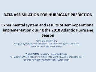
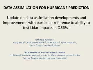
DATA ASSIMILATION FOR HURRICANE PREDICTION Update on data assimilation developments and improvements with particular reference to ability to test Lidar impacts in OSSEs -. Tomislava Vukicevic 1 ,

E N D
DATA ASSIMILATION FOR HURRICANE PREDICTIONUpdate on data assimilation developments and improvements with particular reference to ability to test Lidar impacts in OSSEs - Tomislava Vukicevic1 , AltuğAksoy1,2, Kathryn Sellwood1,2 , SimAberson1, Sylvie Lorsolo1,2, XuejinZhang1,2 and Frank Marks1 1NOAA/AOML Hurricane Research Division 2U. Miami/RSMAS Cooperative Institute for Marine & Atmospheric Studies 3Science Applications International Corporation
HWRF Hurricane Ensemble Data Assimilation System (HEDAS) • Forecast model: • HWRF • 2 nested domains (9/3 km horizontal resolution, 42 vert. levels) • Static inner nest to accommodate covariance computations • Inner nest size: ~10x10 degrees • Data assimilation: • Square-root ensemble Kalmanfilter • Assimilates inner-core aircraft data on the inner nest • NOAA P-3, NOAA G-IV, USAF, PREDICT G-V • Ensemble system: • Initialized from semi-operational GFS-EnKF (NOAA/ESRL) ensemble • 30 ensemble members Aksoy et al., 2012
Observations 2 NOAA Orion P-3 Dropsonde + Flight level + Tail Doppler Radar 1 NOAA Gulfstream G-IV Dropsonde Observation distribution (9/02/2010 02Z analysis) Data types flight level: wind temperature and humidity + SFMR surface wind GPS dropwindsonde: wind, temperature, humidity and pressure Tail Doppler Radar: radial winds. Approximate vertical location Orion P3: ~ 3 km G-IV :13 - 14 km and U.S. A.F. C-130’s: 10km maximum with a minimum 2000ft. vertical separation from the P3’s U.S.A.F WC-130J Flight level + Dropsonde
HEDAS Performance Retrospective 2008-2011 AltuğAksoy
Analysis Doppler-Derived Structure 2008 Fay (1) 2008 Gustav (2) 2008 Ike (1) 2008 Kyle (4) 2008 Paloma (1) 2009 Danny (1) 2010 Earl (1) 2010 Karl (2) 2010 Tomas (1) 2011 Irene (2)
Summary of analysis properties • Very good estimate of 3D primary circulation • Small amplitude but statistically significant negative intensity bias for hurricane intensity cases • Very good estimate of storm location • The observed storm center location was not assimilated • Low skill of the estimate of secondary circulation • Underestimate of both the vertical and radial components • POTENTIAL FOR IMPACT OF LIDAR OBSERVATIONS • Good estimate of axisymmetric structure of temperature and humidity with a bias in mean amplitude
OSSE capability • HEDAS is an off line system with respect to HWRF • Adaptable to any resolution and location • Requires significant computational resource • Observation operators are modular • New operators could be easily added • Required collaboration with the observation experts