Download
1 / 61
610 likes | 720 Views
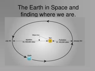
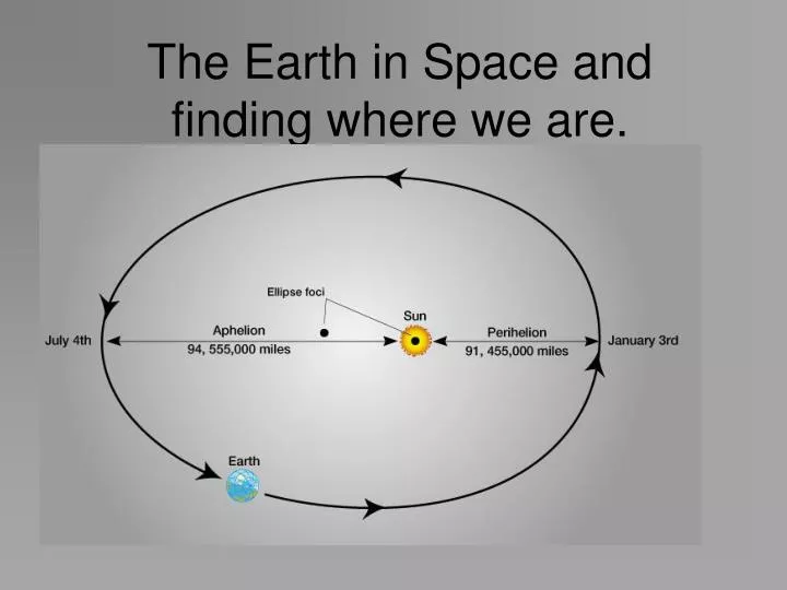
The Earth in Space and finding where we are. The Earth in Space. Where are we, and what does that mean?. June 22. Another way of looking at June 22… www.time.gov. Daylight pattern on 22 September… near the equinox What would December 22 look like?.

E N D
The Earth in Space Where are we, and what does that mean?
Another way of looking at June 22… www.time.gov
Daylight pattern on 22 September… near the equinox What would December 22 look like?
What significance do the tropics of Cancer and Capricorn have?
Weather and Ocean currents are caused by the imbalance of heat from vertical solar radiation between the tropics and very little direct solar radiation at the poles (or none)
Describing Where: spatial referencing systems • Many common applications use only a simple reference grid
Geographic coordinates (Latitude and Longitude). Simple conversion of angles at the earth’s center gives a basic equirectangular projection Common and simple*
the Babylonian system is based on the number 60. Latitude and Longitude are based on a a "sexagesimal" system. A circle has 360 degrees, a degree has 60 min. and each minute is divided into 60 seconds. This nomenclature is known as DMS (degrees, minutes, seconds) • Perhaps a better system is to convert the minutes/seconds to a decimal part of a degree this is known as DD (decimal degrees). e.g. 120 30’ 00” = 120.5
‘Great Circle’ routes • The shortest distance between any two points on the surface of a sphere can be defined by a plane that connects the two points and intersects with the center of the sphere….
The Great Circle Route from HSV (Huntsville AL) to FCO (Rome): The curved flight path north and east crossing Labrador is the shortest route between the two points.
The Great Circle route from Chicago to Hong Kong…. http://gc.kls2.com/
Defining ‘0’ • In terms of latitude, 0 is easy to define, it it the line between the north and south poles where the earth's rotational speed is at its maximum • 0 degrees longitude is much more difficult, as all lines of longitude are equally valid as the base line or ‘0’ • The French (of course) wanted 0 to run through the center of the civilized world… Paris • However, England was the true global maritime power when ‘0’ was established… therefore… as the ‘big dog’ the ‘Prime’ meridian, the baseline runs through the Royal Observatory at Greenwich England.
The importance of ‘time’ • SO how does one determine exactly where you are…. We have established a grid system, Latitude and Longitude… we have ‘0’s fixed in place… now… where are you? • Latitude can be determined from a fixed stellar reference, usually Polaris, the ‘north star’.
The Sextant A device for measuring the angle of a star above the visible horizon
Longitude… no stars are available to show longitude… it requires TIME. The sun requires 24 hours to cover 360 degrees of the earth…. 1 degree every 4 minutes. 15 degrees every hour…. IF I can compare accurate times between 2 locations, I can find the difference in longitude! A pendulum clock cannot be used at sea…. A sundial is dandy, but it only keeps solar time… there is no way to know how far you are from another location
In 1714 a prize was offered: 20,000 pounds In 1727 John Harrison started building clocks to attack the problem of longitude…. Isaac Newton (who was on the search committee was convinced that no clock would ever be invented that could do the job…) John Harrison developed a highly accurate clock which proved to lose only 1.25 minutes in a 2 month long voyage to Jamaica…even though is final time piece was proved in 1762…..it was not until 1772 that the prize was awarded (note that he worked on this for 35 years before success and it was another decade before he got paid!)
GPS: Global Positioning System • The Geographer’s best friend! • You can say with confidence… “I’m not lost!, I’m never lost!”* *Of course, where everybody else is or how to find your destination…. That’s a different question!
For all the ‘high tech’ involved the concept for the system is actually quite simple…. • A network of 24 Satellites in geosynchronous orbit • Each Satellite has an extremely accurate atomic clock and a radio transmitter with a unique frequency • The GPS receiver also has a highly accurate clock and the ability to receive radio signals from multiple satellites at the same time.
Each Satellite constantly broadcasts the time and every 30 min or so it also broadcasts an ephemeris which is the projected location of all satellites in the constellation. The satellite broadcasts the time, the receiver compares the time from the satellite to its internal clock… even at the speed of EMR propagation there is a slight delay… this delay provides a distance to each satellite.
Standard Time • For the average person, feeding the pigs, hoeing the cotton… accurate time was not necessary • Everybody can see when the sun comes up, when its directly overhead its noon and when it goes down its dark…. • The spread of the railroads and more rapid transportation made it necessary to establish standard time zones.
Each time zone is 15 degrees of longitude (the distance the sun travels in one hour). Noon is true solar noon only at the center of the time zone… to the east its past solar noon and to the west it is not yet solar noon….
The negative numbers in each time zone are the offset from GMT or ‘zulu’
Why are the time zone boundaries not straight… nor even along state boundaries?
The international date line… by convention where Saturday becomes Sunday! Cross this line going east and lose a full day, cross going west and arrive before you leave
Making Maps • The earth is round (ish): maps and computer screens are flat • How do I make a spherical object appear to be flat?
While the Earth is ‘roundish’, maps/display screens are FLAT Map Projections are different ways that a curved surface can be displayed FLAT.
A projection can intersect the surface in many different places. There is no distortion at the points of intersection… distortion increases as the distance from the intersecting points increases.
The direction of projection can be changed according to the needs of the person using the data
A complicating factor: the Earth is not really ‘round’. It is in fact an ‘oblate spheroid’*.
Distortion: It is impossible to project a curved surface to a flat display without causing distortion of the features. An almost unlimited number of projections have been developed for the purposes of individual users.